
|
|
Route |
|---|---|
|
|
37.56670°N / 105.4967°W |
|
|
Scramble with off-trail approach |
|
|
A long day |
|
|
Class 4 |
|
|
Background
This is the story of the development of a new route to the summit of Little Bear Peak. If this doesn't interest you, please skip to the Driving Directions and Route Descriptions for the meat of this page.For many years now, the easiest route on Little Bear Peak has been the West Ridge route. That route's defining feature, "The Hourglass" couloir, has the distinction of being the most hazardous section on the standard route of any of Colorado's fourteeners, due to extreme rockfall danger. Some consider the fourth-class crux of this section to be the most difficult climbing of all the standard fourteener routes.
Years ago, the standard route up Little Bear was not the Hourglass route, but rather an approach from Blanca Basin. One ascended the steep south slopes of Little Bear's southwest ridge to access the peak's summit ridge. You can find this old route described in the CMC's Guide to the Colorado Mountains. Problem campers and climbers compelled the owners of Blanca Basin to close access to the public, and this decision led to the Hourglass route becoming the standard.
A couple of years ago, I noticed that much of the land surrounding Tobin Creek, including Little Bear's southwest ridge, was on public lands. No trails penetrate this southern corner of the Rio Grande National Forest, and I contemplated possible routes into it. Before I ever formed any hard plans, I read with interest a trip report from FourteenerWorld's Hakan Bergstrand in September of 2003. He, too, had researched this area, and he successfully used the southwest ridge route to summit Little Bear. His ascent involved a bushwhack from the Lake Como Road up Chimney Gulch, with a loss of elevation when he went down into Tobin Creek and back up to the southwest ridge. For his descent, he followed the southwest ridge to its end and bushwhacked around and back to the Como Road.
Hakan's report was inspiring, and we discussed the route on the forum. Erin and I made an attempt on the route in October, but Little Bear deceived us. We contoured around to Tobin Creek without any trouble, but we were fooled into thinking that if we stayed on Little Bear's west ridge a while longer, the descent to the creek would lessen. This was a poor calculation on my part, and cost us much time. We had started quite late in the morning, and after I broke a trekking pole, a very useful device what with all the talus in the area, we called it a day and bushwhacked back to our car. This turned out to be a wise decision, because we wouldn't have made it back until well after dark, given the time commitment this route demands.
The day wasn't a total loss, however, because I had had the idea of using the diagonal road that follows the Alamosa-Costilla County line in order to shorten the bushwhack and lessen the orienteering difficulties below treeline. With extra time on our hands, we decided to drive up this road and check it out. It's part of a grid of roads south of the Sierra Blanca and north of the town of Blanca. The roads look like they were punched through as part of a real estate development, but it's very sparsely populated. We only saw a couple of trailers alongside the road, and both looked abandoned. There were no fences, no private property signs of any kind. The question remained, however, does this road definitely provide legal access to Little Bear? Calls to the Forest Service yielded varying answers to my question. Some answered "Yes," while others were more hesitant, encouraging me to watch out for signs indicating private property. In October of 2003, Jeremy Petersen, also of FourteenerWorld, used this road to climb Little Bear, even finding a sign marking the National Forest Boundary. This confirmed my suspicions, and now I just had to wait through the winter to try the route for myself.
Driving Directions
IMPORTANT ACCESS UPDATE!Please note, the Tobin Creek Trailhead may not be legally used. Apparently, despite all my efforts to determine its status via the Forest Service, and despite the lack of fences or signage, the roads leading to the trailhead are private.
The following note from Alamosa County SAR was received by 14ers.com member, Terry Matthews:
"The roads you used to access the Southwest Ridge route of Little Bear Peak are private roads. The reason that route is not listed in guides is that several years ago the land owners requested the county sheriff begin issuing trespassing charges for anyone who isn't a resident who is found in that area. If you found recent information about that route, it may be related to the operation to recover Lygon Stevens in 2008. That subject's family and the sheriff were granted explicit written permission to use the private property roads to access the Little Bear Lake Gorge for that operation only. As a SAR unit, we are allowed emergency access, when necessary, through those properties. All others are legally trespassing."
The comment about the "reason that route is not listed in guides" is interesting, in light of the route's subsequent inclusion in Gerry Roach's third edition of his Colorado's Fourteeners book. I find it humorous the suggestion that there's been proactive measures taken by the landowners, yet they somehow failed to contact the single, most popular Fourteeners guidebook author!
Nevertheless, Roach is now aware as he has updated his website to indicate the same access issue:
"20T2 - the Tobin Creek Trailhead. While this trailhead is in the Rio Grande National Forest, the access to it described on page 203 is on private property and this access is limited to those who have permission from the landowners. The description on page 203 is intended for those with permission. If you don’t have permission and want to access Route 20R6 - the Southwest Ridge of Little Bear, go up the Lake Como Road to the boundary of the Rio Grande National Forest at 8,800 feet, then hike south and east to Tobin Creek."
http://www.climb.mountains.com/Book_Land_files/14ers_Book_Fixes.shtml
I will maintain the description for posterity, but again, please be advised that using this route will constitute trespassing, and access is unlikely to be granted by the landowners given the disposition presented in the note above.
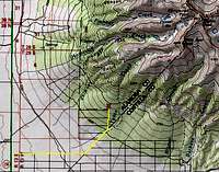 Driving route to Tobin Creek TH
Please refer to the map on the right to aid in the driving approach to this unmarked trailhad, which I'll refer to as the Tobin Creek Trailhead.
If you're coming from the east, drive on US-160 to the town of Blanca. Proceed 5.5 miles to the highway's junction with SH-150. Turn right and drive north for approximately 2.5 miles and turn right on Road 4.4 (shown as 18th Street on Google Maps). If you find yourself at the turnoff for the Lake Como Road, double back and go south for around a half-mile. This is the first road south of the Como Road that heads to the east, and it's in great condition. Drive on Road 4.4 for 2.5 miles where you reach a fork. Turn left and now you're on the diagonal Alamosa-Costilla county line road (Grant Avenue on Google Maps), heading northeast. This road's condition deteriorates quickly, and will remind you of the lower, extremely rocky portions of the Como Road. It is NOT recommended for a low-clearance vehicle. Stay on this road for a little over a mile, where it makes a 45 degree turn (and is renamed Finton Avenue on Google Maps) and begins heading due north along the National Forest boundary. The quality of the road improves somewhat for the final half-mile, while your vehicle climbs a helpful 500'. You'll greatly appreciate this 500' at the end of your day. After the half-mile, the road turns to the west, and this corner is as close as the road will get you. Parking for around 5-6 vehicles is available here without blocking the road.
Route Description
RT Distance: 8 milesElevation Gain: 5400'
Now that I've climbed the southwest ridge for myself, I have some opinions that I'll use to preface the route description. If you want to attempt Little Bear's southwest ridge, be forewarned: this is a long, arduous ascent. Even though this is technically an easier route than the Hourglass, it is a major undertaking and features dramatic exposure during the traverse between the south and main summits. While the route is an attempt to eliminate the rockfall hazard, loose rock is still a primary concern. Test every hold! Relatively speaking, very few have used this route and made this traverse, so loads of loose rocks are just waiting for you to find them! Another caution about the loose rock, this route traverses atop the Hourglass as you near Little Bear's summit. Be extremely careful as you cross, for any rock you dislodge could hurt or kill climbers below you! Lastly, start early if at all possible. Headlamps can assist in the bushwhack, and get you to the ridge climb by dawn. This ridge is very long, and you'll be exposed to the elements for around three-quarters of your climb. Escape from the summit ridge would be a frightening proposition, and it doesn't get much better until you drop below 13,400'. Even then, it would mean a descent down unstable talus to Little Bear Lake. Trying to return from this isolated locale would present a whole new set of obstacles.
 Scrambling on the way to South Little Bear
Please refer to this map when reading the route description. Cacti, other thorny plants of many varieties, and numerous pinon trees will be your chief obstacles during the bushwhack. Pants and gaiters are a must if you don't want needles and stickers in your boots.
Leave the Tobin Creek Trailhead, and begin bushwhacking northeast toward Tobin Creek. You'll likely need to lose 50-100' of elevation to reach creek level. The crux of your bushwhack will be finding a way to penetrate the thick, thorny bushes that clog the creek. The water in the creek is very negotiable, and even during the height of spring runoff, I believe there would be stepping stones for you to use. Once beyond the creek, head to the east for a spell to draw into thinner vegetation before going directly north toward the southwest ridge. Talus intermingles with the vegetation, and you may prefer to rock-hop your way up, when possible. A few hundred feet of climbing brings you to the ridge crest, which you'll follow, more or less, the entire way to the summit. Try to avoid making the assault on these slopes too far east from Tobin Creek, because there are some cliff bands in that direction.
Talus-hopping will be your constant companion during this route, as you make the arduous ascent to the summit. Once past timberline, continue the stiff climb to the first bump of many along the ridge. I don't recommend traversing to these bumps' right in order to avoid extra elevation gain because the talus is so much more stable on the ridge crest. Continue up and over Point 13,132 and the next two or three bumps on the ridge, while you enjoy the spectacular view of Little Bear's west face.
Once past this series of minor bumps and deep notches heading spectacular couloirs, you'll reach the base of your climb up South Little Bear, still 6-700' above you. Most of this climb should be made as near the ridge crest as you feel comfortable to avoid the looser rock. You'll top out on yet another bump on the ridge and face a difficult looking traverse over to South Little Bear. There is a moderate knife ridge, if you want to stay on the crest, or you can take a convenient detour just below it and on the east side. Some easy scrambling past the knife brings you to the summit of South Little Bear. From your perch, you'll love the view of Blanca and Ellingwood, especially your perspective of the fifth-class Little Bear-Blanca ridge that the main summit doesn't provide. The south summit is only 30' lower than the main summit, but a little over a quarter-mile of interesting scrambling still separates you from your goal.
Your descent from South Little Bear presents an immediate obstacle: a fin, characteristic of the area, jutting from the ridge. Avoid this obstacle on the now more accomodating west face by downclimbing and slipping around it. From here, the route features a series of notches and knife-edges, while staying on or near the ridge crest for much of the way. Some of the traverse, comparatively speaking, can be something of a relief. To keep that heart pumping, peer down to both sides, soaking up the incredible exposure. The desperately steep, photogenic east face of Little Bear demands that you look down it at least once. As you continue your scramble, never forget that this route is not frequently traveled, and test every hold!
The top of the Hourglass forms a deep notch in the summit ridge and is your next crux. The ridge crest drops too steeply into the notch to continue your passage, so you're forced back on the west face where a series of ledges and gullies helps you reach the top of the Hourglass's notch. Now that you're in the notch, it's imperative that you take extra care as you pass north to the final summit climb. Any rocks you dislodge will funnel through the Hourglass and place climbers in the deadly couloir in danger.
For the last push to the summit, you finally join the standard route. Using a series of ledges that will now feel downright easy, gain the summit and revel in your achievement when you look back at South Little Bear and at the long, arching ridge you just climbed.
Now, the sobering realization that you have to go back. Depending on your disposition, you'll either welcome or dread the return to South Little Bear. But no one will be looking forward to the long descent down over 4000' of talus. I wouldn't recommend moving too fast, because of the frequently unstable talus. Couple that with some afternoon heat, and you have a tough few hours ahead of you. So much of your care and attention is required that my party had an even split between our ascent and descent times. Once below timberline, a GPS unit can help in locating the trailhead. Otherwise, it's time for your orienteering skills to kick in. Note that there's more than one road in the area. Some are old and run intermittently, while others will make a turn in the wrong direction.
Essential Gear
First and foremost, carry loads of water. Tobin Creek is an unreliable source and too near the trailhead to be of any real use. The southwest ridge receives the full brunt of the blazing afternoon sun, and once below timberline, the trees will do little to block the sun, while stifling any breeze you had the fortune of enjoying earlier. Most of our party carried 120 oz. of fluids or more. We even had the luxury of the wind along much of our descent. Nevertheless, many of us had run dry by the time we made it back to the trailhead.You'll want to be wearing full-length pants and gaiters to help block thorns, burrs, and needles from entering your boots. Everyone in my party, despite the hot sun, chose to continue wearing long sleeves during the return bushwhack to avoid the numerous scratches the vegetation otherwise would have inflicted.
Most parties will be comfortable along the traverse without a rope. Be aware of conditions beforehand, as ice and snow between Little Bear's south and main summits would increase the route's difficulty dramatically.