
-
 4432 Hits
-
 73.06% Score
-
 3 Votes
|
|
Route |
|---|---|
|
|
46.63330°N / 121.0833°W |
|
|
Scramble/Technical Climb |
|
|
Less than two hours |
|
|
Class 3 (Variation estimated at Class 4-easy 5) |
|
|
Approach
For the west face, from highway 12 turnoff onto Tieton Road, go 2.8 miles to Forest Road 1202 (there is a sign there that says "1202 - Spencer Creek"). Turn left onto 1202 and go 1.7 miles to a small parking area on the left with a small brown trail marker with 1126 on it. Park here. Take 1126 (forks quickly to the right from the parking area) as far as you can until the dirt Jeep road starts heading more southeast. Kloochman Rock is more northeast at this point and take a game trail towards it. Just before the base of the rock you will catch a larger path which becomes the Southwest Route.
Route Description
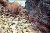
Follow the wide ramp northwest up the side of the face for about half a mile to the base of a scree gully. There is a large dead tree here. Look to your right and you will see a wide gully with a rocky center. In the rocky center you can see a lone pine tree and above that another dead tree snag. This is the line you want. The scree is very loose and treacherous and the rocky center offers the most sold rock. The route weaves in and out of several small rocky spots to a saddle near the higher dead tree.
From here you scramble up the rock wall to your right, easy Class 3. The correct route goes up about half way from the saddle and then right around the corner. See photos for decent views of this route.
For the Douglas Variation, just before you reach the scree gully, at the last stand of pines, look right at the rock face. There is a large "W" shaped rock face which looks like a rock wall in front of two gullies. The notch on the lefthand side (north) had a small piece of white webbing just below an overhanging boulder. I chose not to go this way but rather went up what looked like a stairway on the right notch to a crack just to the right of a bright green lichen patch. Chimney up this notch and over to some 3rd class rock. Beware the staircase is extremely loose and chunks fell every time I touched something.
Once over the notch, scramble into a gully where you will find about 2 or 3 small chimney/stemming problems which appeared to be easy Class 5 to me. They are reminiscent of the crux moves on Broken Top and Mt. Washington in Oregon if you are familiar with those. Work your way up the gully to the summit ridge.
Please note that Beckey's book did not rate this route but called it a variation of the Class 3 Southwest Route. I don't know if that meant it was supposed to be Class 3 or if he had not done the route. I estimate it to be easy Class 5 with mostly Class 4. I don't have any advice for what kind of pro to bring, I was messing around on this route and got too high on loose rock to downclimb and had to free it to the top. But you might want some slings, webbing and large pro. It's easy enough to free but there is some exposure and very loose rock.
 |  |  |  |
Essential Gear
See route description for my "waiver" on gear.
Miscellaneous Info
If you have information about this route that doesn't pertain to any of the other sections, please add it here.