
-
 20579 Hits
-
 79.78% Score
-
 11 Votes
|
|
Route |
|---|---|
|
|
48.30860°N / 121.0941°W |
|
|
Hiking |
|
|
Spring, Summer, Fall |
|
|
Most of a day |
|
|
trail & bushwhack |
|
|
Overview
 This
last stage of the PT takes you on trail (mostly) to the Suiattle
River Road. From the Cub & Itswoot Lakes basin you're done with
glacier travel, but the first few miles of trail demand some
attention to stay on route.
This
last stage of the PT takes you on trail (mostly) to the Suiattle
River Road. From the Cub & Itswoot Lakes basin you're done with
glacier travel, but the first few miles of trail demand some
attention to stay on route.
Getting There
The “routes” of the Ptarmigan Traverse are consecutive stages of a multi-day trek. The approach to Stage 5 is Stage 4. Unless you're going the opposite direction, in which case, read the “Southern Start” paragraph in the Getting There section of the PT main page.
Route Description
Having hiked up through the pass NW of Cub Lake, you're on the Bachelor Creek Trail, at the head of (what else?) Bachelor Creek. Watch it carefully so it doesn't get away from you. Though the trail is covered in the book 100 Hikes in Washington – North Cascades: Glacier Peak Region (Ira Spring and Harvey Manning, The Mountaineers Press), the upper part isn't marked on the USGS Dome Peak quad. There's no mention of it at all on the USFS trails web page for the area. The only mention I found of it on the Web is on a page listing abandoned trails.
Begin with a walk in the park, following the creek trickling through a shallow dell as it gently descends, heading NW for ½ mile (800m). You're mostly in heather meadow, and the creek is small enough to cross at will, but generally keep the creek on your left. After that ½ mile, the creek and trail make a sharp left turn to the SW and start crossing contour lines with a purpose.
The trail crosses to the S side of the creek and about a mile below that left turn, dives into a major thicket of slide alder. I've been down it twice and up it once, and haven't found a more reasonable alternative from either direction. My most recent trip there was in 1991, so my memory of it is a bit general – go around that bend in the creek, cross to the S, descend into Alder Hell, fight it for a while, find a path back to the creek, and cross on a log to find a perfectly good trail on the N side. Yes, I dropped my pack on the trail and jogged up it to find it dead-ends. From there down to Downey Creek, the trail is pretty straightforward.
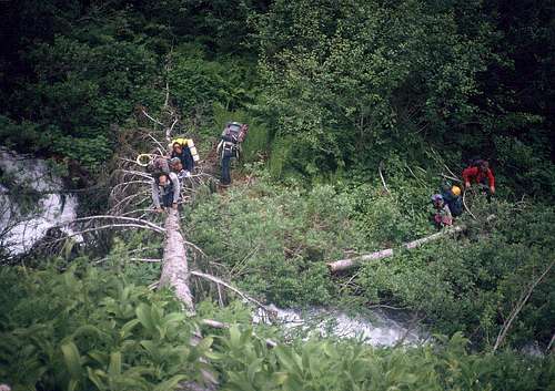 Exiting
the slide alder (visible in the background), cross back to the N side
of bachelor Creek. The trail we're seeking is just a few feet behind
the photographer.
Exiting
the slide alder (visible in the background), cross back to the N side
of bachelor Creek. The trail we're seeking is just a few feet behind
the photographer.
When Ragu submitted his photos from his 2005 trip I asked for an update on trail conditions on Bachelor. I can't improve on his directions or his story:
Funny you should ask that question. My partner and I had a mini-epic on that descent, which could have easily been avoided. We took a wrong turn in the alder, and paid dearly. We traveled about a mile through all kinds of crap... numerous bee hives, overgrown rock slides, pure hell. We finally got smart enough and found the trail on the other side, just before a never-ending sea of the thickest alder I've seen.
When descending down Bachelor from the pass you lose the trail at about 5200', after rounding the broad corner. Here's where you start hitting the huge blow-down with some pretty big trees, that covers a good section of the southeast face above Bachelor. We worked our way almost straight down through the downed trees for a couple hundred feet, using some as highways, and crossed back over the creek to the north side. We soon got out of the fallen stuff, and into a forest of bigger trees. We were able to pick up game trails here and there, and worked our way down to where it flattens out a bit (4600-4700'). We crossed back to the south of the creek, and quickly picked up the trail. The trail through the alder was pretty good, and looked recently hacked... until we took the wrong turn.
Our mistake was that we came to a "Y" in the trail, and we went left. Going to the right sends you back over the creek and to the trail on the north side (approx. 4000-4200'), which goes all the way down to Downey [Creek]. The other 2 in our group had taken the correct turn, and we didn't see them again until back at the cars on the Suiattle. Then to top it off... someone had swiped our stashed 12 pack of cold beers hidden in the Suiattle!
As for camps, there were several bivi sites on the shoulder just below the pass that drops down to Bachelor. Some spots had better water sources than others. On the Downey there were quite a few large bivi spots, and well spaced out along the length of the creek. Most all of the spots would be quite buggy.
The trail remains on the N side of Bachelor all the way down to the Downey Creek trail at 2440 feet (740m). You're still 6+ miles (10km) from the road, but the Downey Creek trail is about as gentle as you can hope for in the N Cascades. The first 2 ½ miles is broad, flat valley bottom, then the valley begins to squeeze in and drop. Most of the last 2 miles is about 400 feet (120m) above the water, always on the E side. A couple of switchbacks drop you down to the road at 1440 feet (440m). In 2005 the road was blocked downvalley from the trailhead; the cars would be a half-mile walk W on the road.
 The
trail is usually in good condition, maintained for hikers and horses,
but check the Forest Service web page for an update. In 1991 the
storms of the previous winter had littered the trails with large
trees and washed out the Suiattle River road, forcing an additional
7-mile walk to the cars.
The
trail is usually in good condition, maintained for hikers and horses,
but check the Forest Service web page for an update. In 1991 the
storms of the previous winter had littered the trails with large
trees and washed out the Suiattle River road, forcing an additional
7-mile walk to the cars.
Peaks to Tempt You
If you just can't get enough, the W ridge of Spire Point extends beyond Cub Lake. Peak 7665/Marmot Head (map) is less than a mile NNE of the campsites at the saddle NE of the lake, and affords a spectacular view of the Spire Glacier and its 600-foot (180m) vertical headwall.
Peak 7088/Pilot Peak (map) could be part of an alternate exit adventure. The Cascade Alpine Guide says the ridge from Cub Pass is straightforward until just below the peak. There, Beckey says, “A slanting tricky chimney (class 4) was climbed on the N face to the ridge; the approach and remainder of the climb are not difficult.” I suspect that description was provided by people who carried only summit packs up the chimney.
Or you can go to Darrington and eat pizza.
Essential Gear
See the Essential Gear section of the PT Main Page. Stage 5 requires no climbing equipment.
Alternate Exits
From the saddle above Cub Lake (The Cascade Alpine Guide calls it Cub Pass.), follow the ridge SW toward Downey Mountain. In about 2 miles, just before crossing onto the Downey Mtn. map, things get technical. Passing this point involves the “slanting tricky class 4 chimney” mentioned in the Pilot Peak paragraph above. If you're exiting along this ridge, the only alternative to the chimney is a 1300-foot descent, traverse, and 1700-foot climb, all on steep sidehill on th S side. Three miles of ridge walking lead to a 6000-foot pass a mile E of Downey Mountain. Descend the valley WNW to a little pond at 4740+ feet (map).
The “Trails and Approaches” section of the Cascade Alpine Guide mentions a Downey Mountain Way Trail hacked by a packer up to this neighborhood. If you can find it, it will take you down to the Downey Creek trail, about 2 miles from the road. If you can't locate the trail, just traverse out away from the outlet creek and walk downhill. It's fairly steep, but uniform.
I haven't hiked or climbed anything on this ridge. All this grand advice is based on the map and a paragraph or two in the book. Personally, I'd just hike home and take a shower.