
|
|
Route |
|---|---|
|
|
48.33508°N / 121.3174°W |
|
|
Scrambling |
|
|
Summer |
|
|
Most of a day |
|
|
Easy Class 3 |
|
|
Overview
This is the most direct route up Hurricane Peak short of making the summit bid a true rock climb. Though the peak looks quiet dominant from Boulder Lake once you come up on the route you will notice that the gully is only Class 2 (though lose) and the total climb to the summit is borderline Class 3. That being said be prepare to deal with plenty of Boulders, talus and scree. While it might take you only an hour or two to the lake except even more if you are planning to summit the peak.
Getting There
FROM DARRINGTON: Take 530 North roughly 5.5 miles miles. Once you go over bridge make a right onto the Suiattle Creek Road and take the road 5 miles. Form there you will see the Tenas Creek Road (National Forest Road 2660) on your left. Take the Tenas Creek Road 5 miles to bridge washout by Tenas Creek. The last stretch is rougher and is difficult for avaerage clearance vehicles to navigate. Park on the side on the area of the bridge washout.Route Description

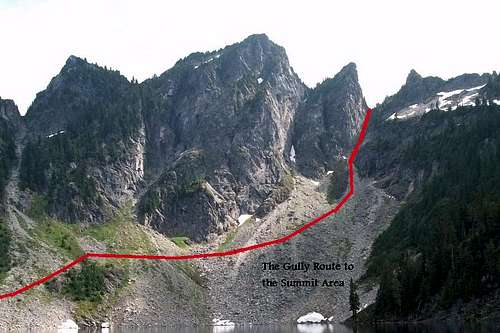
As for the route to the summit you want to take the recently renovated unnamed trail (formerly a fisherman's trail to Boulder Lake) up to Boulder Lake. Thank the WTA for really fixing the trail and actually making this trail much more of a gem than it used to be in the past. Take this trail all the way up to Boulder Lake. Towards the end it is hard to spot the trail because it crosses a number of Talus fields up to the lake. Once at Boulder Lake look for the obvious gully just to the right of the Hurricane Peak summit. It looks very imtimidating from that viewpoint but it is no more than 45-50 degrees and Class 2. It is accessible but a pain to get in that you either travel north or south of the lake but it will require traversing over numerous talus and scree field. Allow some time for this crossing. From both sides these rocks can be loose and require some caution.

Once at the gully you want to head straight up the gully. I would recommend a helmet here just to protect your head from possible rock fall here. Rise up 1100 feet up the gulley as it transition from talus to scree and to finally mixed scree and dirt. Once you near the top of the gully head up the through the trees for the easiest out of the gully. Once out of the gully you will be on the other side of the mountain. You will want to head to the left and traverse the side until you see a grassy steep dirt area semi-ledge to the summit area of Hurricane Peak. This ledge are you rise to the summit is barely Class 3 at best but can be quiet steep if still covered in winter.
Essential Gear
Spring: Ice axe, helmet and maybe cramponsIn summer I strongly recommend bringing a helmet for this route. There a good chance of rockfall here and If there is a climber above you more than likely he will be kicking rocks on you. It should be noted though that this mountain is not very popular (we were the first to sign the summit register in three years.