

|
|
Route |
|---|---|
|
|
19.23330°N / 98.0333°W |
|
|
Hike |
|
|
Most of a day |
|
|
Walk up |
|
|
Approach
 Start of trail from resort.
 Trail goes behind the tower.
 Trail behind the radio tower.
See the main page for information on getting to the resort. From the Imss Resort a gravel/paved road continues above the resort that is closed to vehicles. After almost 5 km (approx 1 hour) there will be some old building foundation ruins that are now home to a radio tower. You can either follow the road that switchbacks to the west or use the sandy trail that runs straight up to the slope above.
Route Description
 Standard and Alternate Routes
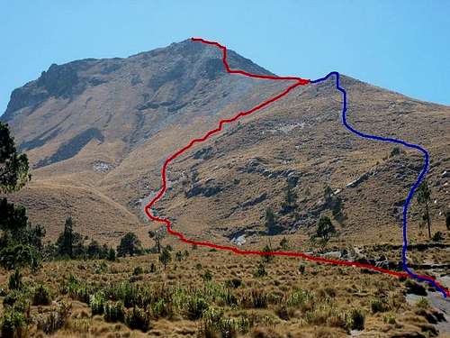
The trail runs through a short stretch of forest to the grassy slopes below the the summit ridge. Climb towards the northern false summit then follow the summit ridge to the true high point. At times the route is a braided trail so pay attention to your directions. Unless you have low visibility there should not be any problems. The route time is 4 - 6 hours from the resort to the summit.
Alternate Option
Rather than following the standard route (red line) in the photo taking a more direct approach (blue line) up and over the rocks to the small sub peak seen in the photo is easier going. Use the red line for the return trip.
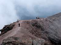 Final ridge as seen from the summit.
I have gone this way a few times and found the difference between the two routes to be substantial. The standard route is mostly sand and scree while the alternate route offers more solid footing. Unless you like to loose 1 step every 2 then go up the alternate route and quickly descend the standard route for less wear and tear.