

|
|
Mountain/Rock |
|---|---|
|
|
19.23083°N / 98.03194°W |
|
|
Hiking, Mountaineering, Scrambling |
|
|
Winter |
|
|
14640 ft / 4462 m |
|
|
Overview
La Malinche is in the state of Tlaxcala east of Mexico City and north of Puebla, 44 kms from its capital Tlaxcala. It is frequently used as a training/acclimatization climb by mountaineers whose main goal is to climb one or more of the "high" volcanoes. It's elevation is 4462 meters or 14,640 feet and the walk up there is pretty easy. On sunny weekends Mexican families try to get up there with their children and grandparents, mountain bikers drive around in the parks dirt roads, and sport-fanatics make it all the way to the top running! No special equipment is required as there are no dangerous parts and the trail is very easy to follow so no guide is needed.
La Malinche is within Malinche National Park. There is a paved road that goes all the way up to 3100 meters where you can park and also sleep in the "Centro Vacacional IMSS La Malintzi. They have about 40 cabins, camping area, a shop, restaurant, basketball and soccer fields, etc. So if the reason for you going to the mountains is seeking silence and solitude, don't go there on a weekend!
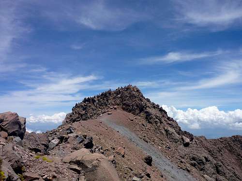 The summit of La Malinche. If you zoom in you can see all of the people up there!
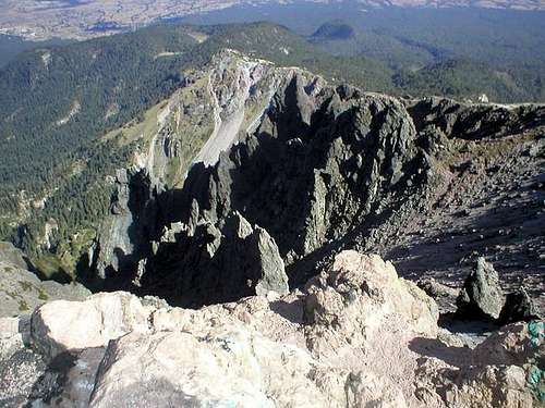 The crater of La Malinche.
Dedication of this Page
On Saturday, November 20, 2010, Chris Pruchnic (Haliku) lost his life in an ice-climbing accident in Colorado's Rocky Mountain National Park.
Haliku, the previous maintainer of this page, was a valued contributor to SP, but his worth went well beyond the pages he created and is missed very much both from friends who have climbed with him, and by anyone who asked him for advice about climbing.
Written below is a beautiful tribute from one of his long time friends.
He always was willing to give a hand or advice to anyone in anyway that he could, and he always wanted to share his joy of climbing and exploring other cultures with his friends and fellow climbers. The climbing community and the world needs more people like Chris, not less, which makes the tragedy of his early parting so much more difficult to accept. He will live on in our hearts and memories. He and I had been talking about climbing Kilimanjaro soon, and someday when I stand atop that peak I will call Chris' name to honor my friend. --chicagotransplant
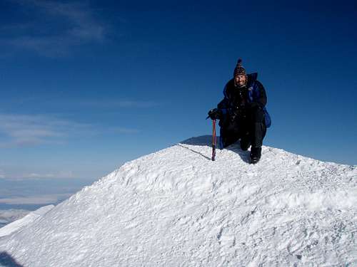 Haliku on top of Denali on 25 May 2009.
Getting There
Access is very easy.
PUBLIC TRANSPORTATION
From Puebla, make your way to the CAPU Bus Station, which is the main bus station for Puebla. Your next destination is Apizaco, which is serviced by several bus companies.
The first bus ('collectivo') for La Malintzi from Apizaco leaves at 8:20 AM from the corner of Av. Hidalgo and Av. Serdan (in front the 'Elektra' store). Come in time because it fills up fast with people working at the 'centro vacacional'. The bus drops you off at 9 am at the entrance of the centro vacacional, where the trail starts. To return, there is a bus at 1 PM, 3 PM and at 5 PM, which is the last one, but it gives you more than enough time to summit, go down and have a late lunch. Note that the 3 PM bus only exist on Friday, Saturday, and Sunday. The other bus times are for all seven days of the week. The bus fare is only 20 pesos one way (about $1 US).
Alternately, if you want an early start, you can take a taxi from Apizaco to the trailhead.
Update from SP member nixoriugis
There is a bus every 20-30 minutes during daytime from TAPO to Apizaco by Atah if you want to avoid Puebla.
There will be dozens of colectivos around the Elektra. You are looking for the one written Teacalco or San José Teacalco, on the South side of Serdan between Juarez and Hidalgo. Price asked was 25 pesos per person, but for 200 total the driver left immediately (8 am instead of 8:20) with only my party and one local and made no stop except to drop that local.
There was only a return at 5 pm (it was Wednesday if it matters), but we could surely have arranged something with the colectivo driver if we wanted.
DRIVING
If you have your own vehicle, the quickest route is now through Canoa, since the road has recently been paved. The road is very windy and slow, but shorter than the route through Apizaco.
Start from Puebla and drive towards La Malinche to the town of Canoa. From there a paved and later dirt road goes all away around La Malinche joining the main road to the "Centro Vacacional" about 1 km before its end. A third (paved) road starts from Huamantla joining the main road at the same intersection about 1 km below the "Centro Vacacional".
Alternately, from Puebla, drive north on Highway 119, past the city of Tlaxcala to Apizaco. From Apizaco, take Highway 136 east 13 kilometers to a signed junction, pointing the way to the "Centro Vacacional IMSS La Malintzi". Stay on this main road for 9 kilometers to the "Centro Vacacional", where the pavement ends.
On all of these roads you will pass a military post at the entrance of the National Park, asking you some question and writing down your licence plates. Usually no entrance fee is required.
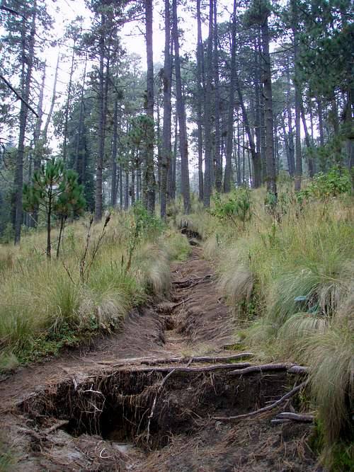 he path not far above the trailhead.
Routes Overview
Centro Vacacional Route
This is by far the most popular route on the mountain.
After the "Centro Vacacional" (see above) the pavement ends and the dirt road continues about another 5 km up. But due to the heavy traffic on weekends the government closed this road with a gate and you cannot pass it anymore. So you will have to start your trip to the Malinche at the "Centro Vacacional".
If you have a car, leave it either somewhere outside the "Centro Vacacional" or - safer - inside the "Centro Vacacional" paying a small fee of about 20 Pesos. If you choose to sleep in the "Centro Vacacional" you can leave your car there the whole day without any additional fees, just be sure to check out the room before 13:00.
From the locked gate on the road, walk up the road and then trail marked with arrows that shortcuts the switchbacks on the old road.
After 30 minutes or so, you will come to a marked trail at the end of the old road. The good trail continues up the mountain and to treeline. It is easy to follow. There are several campsites around timberline, but no running water.
Not far above timberline, the trail will split into several trails. For the ascent, gaining the ridge earlier is easier and avoids a sandy incline that is best for the descent.
Once on the ridge, follow it to the summit. The end has some easy class 3 scrambling right at the summit.
When dry, this route requires no special equipment, but trekking poles are recommended. If the route is icy, an ice axe and maybe crampons are needed.
See the route page for more details.
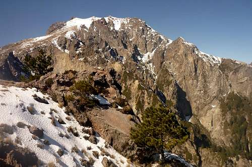
 High on the Centro Vacacional Route.
Altamira Route
This route climbs the mountain from the northeast. This is the second most used route on the mountain. From Huamantla, take a taxi or collectivo to Matamoros. (On the west end of Huamantla, there is a sign that points the way to "Camino Rural-Altamira 8 kms", if you decide to walk it).
If you haven't hired a taxi from Huamantla, from Matamoros you may or may not get a ride to Altamira, but you can always walk (most people would need two days round trip to the top of La Malinche if no taxi is taken).
From Altamira, take a left at the church and walk to the end of the road. There is a school there. The route to the top of La Malinche is at first on a 4wd road and then a well used trail reaches the summit.
There are good campsites around timberline.
If using a taxi to get to the trailhead, the climb can be done in one day. Most may need to spend the night if walking from Huamantla or Matamoros.
Ixtenco Route
This route climbs the east side of the mountain from Ixtenco. It is said to be a very scenic route, but is longer than the route from Centro Vacacional.
See the route page for more details.
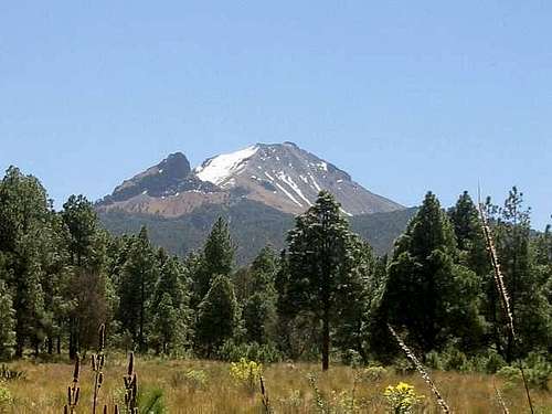
 The east face of La Malinche as seen from the Ixtenco Route.
Axaltenco Route
Some maps show a trail from Axaltenco to the summit of La Malinche. This is on the south side of the mountain. Since Axaltenco is at 3200 meters, it should be a day climb from there.
San Isidro/Canoa Route
This is a route from the southwest side of the mountain. In 1992, some of my friends did a service project in these two little towns in order to provide them with clean water. After the service project, they climbed La Malinche on a trail from San Isidro. No maps show this trail, but it is very likely that it still exists and is used occasionally.
It would be a long all day climb.
 La Malinche from Canoa.
Red Tape
No permits are required to climb. There is no entry fee or parking fee if you park outside the "Centro Vacacional". This is also true for camping.
When To Climb
The dry season is November through March, which is the best time to climb. April and October can be good, but May through September tends to be wet with rain and snow.
November may be the best month since it is by far the least crowded month in the dry season.
The "Centro Vacacional" is open all year round, so you can go there anytime if the weather is good.
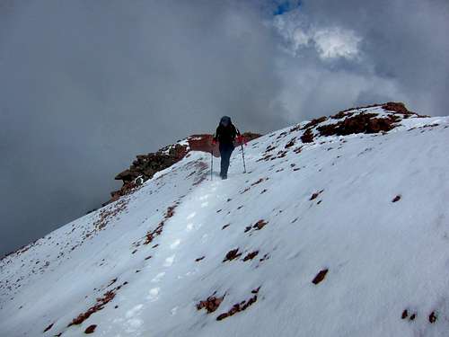
November snow on La Malinche.Guidebooks
RJ Secor's guidebook for Mexico's Volcanoes: A Climbing Guide is one source of information on climbing La Malinche and some of the other higher mountains in Mexico. The book is quite outdated though.
The Climbers and Hikers Guide to the World's Mountains and Volcanoes has lots of good information on the mountains in Mexico.
For complete information on getting to Mexico and traveling around I highly recommend the Lonely Planet guidebook on Mexico.
Camping/Cabanas
The "Centro Vacacional" is a huge resort with cabañas (huts), camping area, a little shop, a restaurant and bar, basketball, soccer fields, etc. All of the huts have hot showers, TV, fridge, kitchen, fireplace (take your wood with you or buy it at the entrance) and come with either 4 or 6 beds. Be sure to check if the hut is fully equipped before you pay.
On weekends this place can get crowded by Mexican families or teenage groups taking lots of beer and music with them and partying so don't expect this to be a "cozy and quiet resort lost in the mountains". The cost varies during the week (weekends are more expensive) and also during the year. High rates are about 490 Pesos for a 4-bed hut and 690 Pesos for a 6-bed hut. Low rates are about 80 to 100 Pesos lower.
There is also a campground within the "Centro Vacacional". The price is around 40 Pesos per person. For both the campground and the huts the checkout time is 13:00, but you can leave your car within the "Centro Vacacional" until your return from La Malinche. To ask for available huts and/or prices call the "Centro Vacacional" at (246) 462-4098.
If you don't like using the resort you can camp at no fee just outside the "Centro Vacacional" in the forest. There are lots of flat places around, even some accessible by car.
Alternatively take your gear and walk about two hours up the trail towards the La Malinche. There are campsites around timberline (~4000 meters). For your next day climb to the Malinche you can hide your backpack somewhere in the woods.
Mountain Conditions
CLICK FOR LA MALINCHE WEATHER FORECAST
Weather averages for Nevado Toluca at elevation 14,052 feet/4283 meters are below. La Malinche should have a similar climate, but the temperature on top may be a few degrees cooler.
| Month | High (° F ) | High (° C) | Low (° F ) | Low (° C) | in. Rain | mm Rain | Rain/Snow Days |
| JaN | 45 | 7 | 27 | -3 | 0.60 | 15.3 | 2.7 |
| Feb | 46 | 8 | 28 | -2 | 0.52 | 13.2 | 2.6 |
| Mar | 49 | 10 | 31 | 0 | 0.49 | 12.4 | 2.5 |
| Apr | 50 | 10 | 32 | 0 | 2.22 | 56.4 | 6.6 |
| May | 50 | 10 | 32 | 1 | 4.58 | 116.4 | 13.4 |
| Jun | 49 | 9 | 33 | 0 | 8.06 | 204.6 | 19.9 |
| Jul | 47 | 8 | 33 | 0 | 9.59 | 243.5 | 24.5 |
| Aug | 47 | 8 | 33 | 0 | 8.98 | 228.1 | 23.0 |
| Sep | 47 | 8 | 33 | 0 | 8.21 | 208.4 | 21.2 |
| Oct | 46 | 8 | 31 | 0 | 3.46 | 87.8 | 12.6 |
| Nov | 45 | 7 | 29 | -1 | 1.07 | 27.1 | 4.5 |
| Dec | 45 | 7 | 28 | -2 | 0.59 | 15.1 | 3.0 |
nixoriugis - Sep 19, 2017 10:49 pm - Hasn't voted
Public transportUpdate for June 2017 There is a bus every 20-30 minutes during daytime from TAPO to Apizaco by Atah if you want to avoid Puebla. There will be dozens of colectivos around the Elektra. You are looking for the one written Teacalco or San José Teacalco, on the South side of Serdan between Juarez and Hidalgo. Price asked was 25 pesos per person, but for 200 total the driver left immediately (8 am instead of 8:20) with only my party and one local and made no stop except to drop that local. There was only a return at 5 pm (it was Wednesday if it matters), but we could surely have arranged something with the colectivo driver if we wanted.