
|
|
Route |
|---|---|
|
|
45.74000°N / 122.23°W |
|
|
Short Weird Scramble |
|
|
Less than two hours |
|
|
Class 4 |
|
|
Approach
This is kind of a tongue-in-cheek route. Certainly it is a viable route to the top of Sturgeon Rock but it's not something you should specifically go up there to do. I offer it as an alternative to those comfortable enough to climb Class 4--particulary unroped. The climbing is up interesting rock/vegetation on Sturgeon Rock's North Face.
The approach to this climb is the standard one for Silver Star Mountain (South Ridge Trail). You can approach from other directions (such as the Tarbell Trail) but they will all be longer. At the point where the trail reaches the junction with the Indian Pits Trail (Star Trail #174) on the right (4,060 ft), a rocky trail goes downhill to the left (west). Take this downhill trail toward Sturgeon Rock.
In about 400 yards the basalt columns that comprise the east end of Sturgeon Rock will come into view to the right (north) of the trail through a belt of trees. Leave the trail here and hike a short distance through open woods to the clearing below the columns.
 |  |  |  |
Route Description
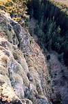
Climb up to the base of the columns or veer right to the east end of the massif. Turn the corner and scramble horizontally along the backside (north side) of the massif. The scrambling is Class 3 at most but not really hard. You aren't climbing at this time but merely traversing the base of the columns on that side. Interestingly, the columns appeared to be slightly narrower on the north side. Or maybe it was my imagination.
Continue along the base with some minor exposed traversing above short cliffs. Some brush will impede you. You could descend into the trees or edge of the forest to get around the brush but you should be able to get past it during the traverse. Some green belay hang-outs over the edge to get around the brush will probably be necessary. I say all this but it's not really difficult. Just your standard brushy scrambling terrain. And actually, it's not all that brushy. Although, I was there in November when all the leaves had fallen off. It might "appear" more foreboding in the thick of summer.
Eventually--maybe about 100 yards down the wall from the east end of the massif--a tree will become visible on the crest above. This tree is about 50 feet west of the summit. Actually, its trunk is on a ledge below the crest but its upper branches are above the crest. This is where you will be climbing up. The face gets steeper again if you continue down the wall.
Begin climbing up wherever you want to. Your objective is the tree, which is about 100 vertical feet up. It looks like you could begin climbing up slightly to the tree's east. I myself went straight to it from directly underneath.
The climbing is unlike anything I had done before. It is essentially giant stair-stepping up columns. Each stair flat has a rug of grass and moss underlain by thick soil/dirt--quite spongy, in fact. The stair risers vary in height but typically range from two feet to three feet. At some points you will have to use balance to step up. At other points you can dig your claws into the rug. I geed and hawed on my way up to the tree in pursuit of easier steps. It took me about 10 minutes to get to the tree.
The crux (for me anyway) was probably the move or two just before the tree. The little bit after the tree to gain the crest was also interesting. For me none of it was hard and there wasn't much pucker-factor going on. I wondered if I fell how soft or hard the bumping down the spongy column tops would be. I wasn't about to find out.
Once on the crest, the rest of the route to the top is Class 2/3.
Time: 30 minutes from the Star Mountain Trail junction, 10 minutes on the face (unless you lead/belay it, in which case it will be take longer).
 |  |
Descent
Walk westward down the crest ("Sturgeon Fin"). At some point you will cross the Clark-Skamania County line. Continue west until it is feasible to climb down the south side. The first opportunity is maybe 100 yards west of the summit. Once below the massif, descend cross-country to the trail, which is not very far into the trees.
 |  |  |
Essential Gear
You don't really need any special gear over and above simple hiking stuff. I say this with the thought that you should be able to free-climb the route unroped. If you can't free-climb it because it's too hard for you, it is a simple matter to bail and walk back around to the south side.
However, if you would like to be belayed, suggest a 30m rope and one or two pieces of pro. Cracks are there but not prevalent. Some horn slinging might be possible.
jtschanz - Dec 15, 2004 11:31 am - Hasn't voted
Route CommentIt's interesting to note that the USGS maps show Sturgeon Rock in the wrong place. See for example http://www.topozone.com/map.asp?lat=45.7398&lon=-122.25&size=l&symshow=n&datum=nad83&layer=DRG25
The peak labeled Sturgeon Rock is incorrect - Sturgeon Rock is actually the steeper and taller rock to the east, closer to the summit of Silver Star.
Klenke - Dec 15, 2004 1:01 pm - Hasn't voted
Route CommentYes, that is true. I thought I mentioned that somewhere (like maybe in a picture caption) but I can't find it now. Maybe it was in my trip report.
This is the true location of Sturgeon Rock.
This is where the USGS erroneously puts it.
Note that they've also got Pyramid Rock in the wrong place. This is Pyramid Rock (Pt. 3577).
jtschanz - Dec 15, 2004 1:38 pm - Hasn't voted
Route CommentThanks Paul - I didn't realize that Pyramid Rock was mislabeled too!
Brian Jenkins - Dec 15, 2004 1:55 pm - Hasn't voted
Route CommentI'll try to put this info into the main page guys. I remember my first hike in on this one being confused about Pyramid Rock. It is so obvious that it is the big rock by the trail not the mound back behind you as you exit the forest. Looks like USGS mismarked a bit of info in this area.
Brian Jenkins - Dec 21, 2004 12:54 am - Hasn't voted
Route CommentHey Don, did you realize you just put your cell phone and address on the internet for all to see? Might want to delete that. Be careful.
Don Nelsen - Dec 21, 2004 10:07 am - Voted 10/10
Route CommentHi Guys. I noticed these errors too and sent in the following to the USGS:
To: gnis_manager@usgs.go 10/07/2004 07:21 PM
Subject: Errors on published maps
Dear Sirs,
I have noticed what appear to be errors in your mapping database.
1: In Clark Co., Washington state, Larch Mt. quad: The point marked Sturgeon Rock at 45 44 44N 122 16 09W: Sturgeon rock is the point 1.1 miles to the east at approx. elevation 4,100' and at coordinates of 45 44 54N 122 14 52W
and:
2: The point marked Pyramid Rock at 45 43 52N 122 15 15W: Pyramid Rock is the feature located .25 miles to the north at 3,577' elevation at coordinates of 45 44 03N 122 15 11W.
The errors also exist on your larger scale maps.
I live in this area and know the area in question very well and am certain of the above. I can provide photographs, if requested.
Best regards,
Don Nelsen Vancouver, WA E-mail: donnelsen@yahoo.com
I received the following reply:
Fri, 10 Dec 2004 09:20:27 -0500
Dear Mr. Nelsen:
Thank you for your email message of 7 October 2004, regarding the name Sturgeon Rock in Clark County, Washington. We have reviewed your comments and concur. We have updated the geographic coordinates for the feature named Sturgeon Rock in the Geographic Names Information System (GNIS). These changes should be evident at the web site today.
We are grateful that you took the time and effort to notify us and help make the GNIS database a better and more accurate data source. Please contact us if you have any questions or comments.
Sincerely, For Manager GNIS
Ms. Eve Edwards
eedwards@usgs.gov for gnis_manager@usgs.gov 523 National Center Reston, VA 20192 (703)648-4548
Presumably, I'll eventually get an answer to the Pyramid Rock question, as well.
Here's the link to report errors if you know of some others: USGS error reporting link
Best regards,
Don
Don Nelsen - Dec 21, 2004 10:12 am - Voted 10/10
Route CommentThanks, Brian. It's fixed now, plus I added the error reporting link.
Don