
-
 2805 Hits
-
 76.09% Score
-
 7 Votes
|
|
Route |
|---|---|
|
|
48.15534°N / 120.35321°W |
|
|
Hiking, Scrambling |
|
|
Summer, Fall |
|
|
Half a day |
|
|
Class 3 |
|
|
Hike/Easy Scramble |
|
|
Overview

While there are many ways you can approach and climb this peak. This route describes probably the shortest. The route starts on the south end of the Sawtooth Ridge and climbs up and over North Navarre Peak’s shoulder on its way to the south ridge of Horsethief Peak (so you can get two for the price of one here). The route is mostly trail until the last 4/10ths of a mile and then it’s Class 2 or easy Class 3 off trail to the summit. The route climbs 2480 accumulated feet in just under 4.7 miles. It’s a nicely graded trail for 4.3 of those miles. (About 9.25 miles round trip if not continuing on hiking/backpacking with an accumulated 3450 feet of elevation gain.)
Views open up after a couple miles with nice views of South Navarre Peak to the west and Bryan Butte to the east. Once you gain the shoulder of North Navarre Peak, you really get some views of the Sawtooth Ridge to the north and lots of 8000+ foot peaks north and west.
The route doesn’t have any water sources until you get to the summit and see Sunrise Peak down the north slopes. Once past the summit though, there are lakes and streams in most basins. If you are planning just a day hike, you’ll want to carry sufficient water then. But most come here to backpack and peak bag. If that is your plan, you’ll not really have to worry about water sources, just where you want to descend off the Ridge to get it.
This area is not really utilized like you’d think will all these high peaks, at least not by the masses. Motorcycles are allowed on some trails in this area though so you need to be aware of them (although you will hear them miles away). But the views are great and there are many mountains to summit in this area. This route in will also get you pretty much right into the middle of the Sawtooth Ridge, and from there, just have a lot of fun.
Getting There
See the main page for directions to the Summer Blossom Trailhead described under the "South Side Approach."Route Description
From the trailhead at 6435 feet, ascend the Summer Blossom Trail about .6 of a mile until the first major switchback to the left. About another .4 of a mile, at the 1 mile mark from the trailhead, you’ll switchback right. Views begin to open up to the south and east. You’ll climb another .35 of a mile on the trail (at about 7300 ft.) where you will round North Navarre Peak’s SE Ridge and now be on its west side. Now you’ll have views of South Navarre Peak. (see photo below)
From this point, the trail slowly ascends northwesterly until you gain the ridge (you’ll gain about 370 feet over .75 of a mile). Where the trail meets the ridge, you’ll then have views in all directions and see part of the Sawtooth Ridge ahead. It’s also a good place to have lunch or a snack.
The trail then angles more west for .1 of a mile until you crest the left shoulder of North Navarre Peak and the ridge that heads out west towards South Navarre Peak (shoulder is at 7850 feet). If you want to bag North Navarre Peak, go off trail to the right (NE) 1 or 2 tenths of a mile and about 120 feet higher to the rounded summit. Come back to the same spot on the shoulder though to regain the trail to continue on to Horsethief Peak. (see photo below for view from the summit of North Navarre Peak showing your route)

From the shoulder of North Navarre Peak, the trail heads mostly north (slightly west) and descends on the west side of North Navarre Peak below its summit for a half mile and loses about 300 feet until it regains the ridge. The reason being is that this side of North Navarre is very cliffy with crumbly rock. The trail is cut into the side of the cliff until it gets past the rockiness and back onto the soft ridge.
Back on the ridge, the trail continues to angle down slightly and turns left to a more northwesterly direction. You lose another 300 feet as it contours around the side of a bump on the ridge (or a large gendarme, or a minor sub-summit, whatever you want to call it – it’s a raised point on the ridge but not enough to be called a peak) through a grassy meadow area with old burned out snags. Beware of bears in this area. We ran into a mother and two second summer cubs who were fortunately freaked out by our sudden appearance because there was definitely more poundage and numbers on their side.
As you contour around this last bump (see photo below for view back south towards North Navarre Peak from where you start to contour around the last bump to see what you would have just hiked through),

you will start to ascend once more and go up to about 7550 feet and back into a sparse forested slope. You will then descend a couple hundred feet and come to another saddle between this bump you just contoured around and the final ridge up to the summit of Horsethief Peak. This is at about 7340 feet and 4.35 miles into the hike. This is where you say goodbye to the trail.
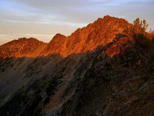
At this point, head straight north and stay on the ridge for .4 of a mile climbing another 660 feet to the summit. It’s fairly easy to just pick your way through the trees and around the increasing number of rocks although you’ll encounter some Class 3 sections but nothing really difficult. When you run out of ridge, you are at the summit and can sign the summitlog hidden in the rocks. (photo below of the summit from slightly west of it)
If you are continuing on, you will be able to see Sunrise Lake below and to the north. This is a great camping spot. To get there scramble left along the ridge from the summit along the lip of the ridge until you find a break in the rocks below to scramble/scree ski down. There are several places along the ridge where you will need to descend to stay in Class 3 terrain but come back to the ridge as much as you can as if you go too far down the side, you’ll cliff out. Try to come back to the ridge and stay on it but there is no need to do anything harder than Class 3. If you are on Class 4 or higher, you are off route. There is an obvious break in the rocks to descend down to Sunrise Lake but if you don’t like skiing steep scree, you can continue past that break and eventually come to the pass where there is a trail that goes down west to the Summer Blossom Trail or east to Sunrise Lake. I don’t know what that section between the break and the pass is like though as it was dark when we were there and we didn’t want to test it any further. It looked blocky but not sure how technical it got.
Otherwise, if you are not continuing on, you can return the same way you came making it a 9.25 mile round trip with 3450 feet of elevation gain day with all the ups and downs.
Photo below is of the southwest side of Horsethief Peak from Horsethief Basin showing the summit. It's pretty steep and really loose here with small cliffs so you'd want to stick on the ridge to the right or at least in the trees, or, along the ridge line up top as best you can to maneuver around.

Essential Gear
If doing this as a dayhike and just bagging North Navarre Peak and Horsethief Peak, bring enough water for a 9.25 mile round trip hike as there is no water directly along the route. (2-3 liters depending on your speed)If doing this as a start or part of a backpacking trip, you'll only need to bring enough water to get to the summit and scramble down to Sunrise Lake (about 5 or so miles one way) for water.
If you are not headed to Sunrise Lake and are staying on the west side of the Sawtooth Ridge, there is water to be found if you continue north on the Summer Blossom Trail to the head of the Horsethief Basin and crest the pass there to go down into the next basin where the headwaters of the Prince Creek can be found. That will add at least another mile or so and some elevation gain and then a switchback down into that basin.
Other than that, I'd advise to bring some pepper spray for possible bear encounters and if in early summer, insect repellant.