
-
 6363 Hits
-
 81.39% Score
-
 14 Votes
|
|
Mountain/Rock |
|---|---|
|
|
48.15534°N / 120.35321°W |
|
|
Okanogan/Chelan county line |
|
|
Hiking, Scrambling |
|
|
Summer, Fall |
|
|
8002 ft / 2439 m |
|
|
Overview

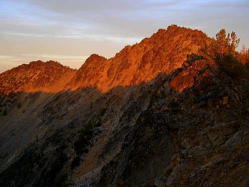
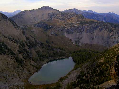
Horsethief Peak is the unofficial name for Peak 8002 located on the Sawtooth Ridge between Switchback Peak (also called Cooney Peak and Peak 8321) and North Navarre Peak in the Lake Chelan Sawtooth Wilderness in central Washington state. It sits on the ridge over Horsethief Basin to its west and Merchants Basin to its east. It also lords over Sunrise Lake on its northern slopes. This is a fascinating area in that it is much drier than the rest of the Cascades being in the rain shadow east of Lake Chelan but it is still very forested with a multitude of lakes and streams so that water is never really a problem. The one problem this area has is that most of the trails are open to motorcycles so the buzz of dirt bikes can be heard but in the time I spent there, the bikers were courteous, friendly and stuck to the trails. Heck, they need a place to be too, right?
The peak is characterized by blocky Class 3 terrain in most directions except for cliffy somewhat vertical off the north side of the summit and easier Class 3 up the south ridge. Scenery is amazing in all directions with a number of Top 100 Washington peaks to the north and west. Trails run in the basins on both sides and somewhat along the Sawtooth Ridge itself. It’s easy enough to take trails and head cross country to bag most peaks in this area or to get out of trouble you may get yourself in to. The main crux of these peaks are the roads getting in. We found mostly forested dirt roads (you might want to bring something to chop or saw through blowdown) with confusing forks, missing signs and extra roads not on maps to confuse the heck out of you. I’d also suggest not driving in at night or who knows where you’ll end up.
One of the peaks in this area was bound to be called Horsethief Peak as there are basins and creeks with the same name. It’s easy to picture some old rustler driving stolen horses into the hidden cirques and meadows to hide out until the coast was clear. The basins on both sides are picturesque and a dream to hike through with lakes, streams, flowered meadows, marmots chirping and peaks calling out, “Scraaaaaaamble me…………cliiiiiiiiimb me.” You can hear them too, can’t you?
There is a summit register in the rocks at the summit to sign and views to be had. Just watch for summer thunderstorms because you are 8000 feet closer to getting zapped here and also be wary of hunters in the autumn. Horsethief is a worthy one to bag as you hike in this area picking off the bigger names on the Sawtooth Ridge like Bigelow and Martin. You can’t go wrong in this uncrowded part of the Washington mountains. And there are numerous campsites around the lakes as well as established camps on the trails.
The easiest route to the summit is from the south via the Summer Blossom Trail. It's about 4.7 miles one way with 2480 feet of elevation gain.
Getting There
I can confirm a line from the pass between Switchback and Horsethief up to Horsethief’s summit via the Angels Staircase Trail up from the Summer Blossom Trail that runs parallel to the Sawtooth Ridge on its west side. You can take this trail from south (described later) or the north from the trailhead on Poorman Creek Road via Forest Trail 420 that travels south over Hoodoo Pass to meet up with the Summer Blossom Trail (not sure if from that direction it is called the Summit Trail though).
North Side ApproachTo get to that trailhead though, it would appear you go from the town of Twisp, WA, and take the Twisp River Road west about 2 miles to Poorman Creek Rd and take a left onto that road. Follow that road past Black Pine Lake going left at FR 400 to the hairpin curve about 4 miles later where an old road continues southwest from the hairpin and turns into FR 420.
East Side ApproachTo get to an east side trailhead, you would need to find your way to Highway 153 between Carlton, WA and Methow, WA. About 7 or 8 miles south of Carlton (or the same distance north of Methow), take FR 4340 west past Foggy Dew Campground to FR 200 on your left (should be just shortly after the campground). Take FR 200 left to road’s end and the trailhead into Horsethief Basin
South Side ApproachFor the shortest approach (hike-wise) and the way to do the Sawtooth Ridge from the south, we opted to start from the Summer Blossom Trailhead on Grade Creek Road. I do caution though that the roads in are convoluted, confusing and although we wrote down the way we took in, I’m not entirely sure I could repeat this. Please take a detailed gazetteer or recreational atlas so if you get confused you can find your way out. Not all the roads are on the maps and I’m not sure what I thought were abandoned trails might be considered roads worthy of being on a map. I’ve been on a lot of forest roads in my day and this was one of the more confusing places to navigate through.
With that said, we went 3 miles northwest of Methow on Highway 153 to Forest Road 200 on the left (west side of the highway). It is where you cross McFarland Creek for the third time out of Methow. You’ll curve back to the right and parallel Hwy 153 a short distance and pass some small homes/trailers along the road where people may or may not be sitting in lawn chairs along the highway waving to you. Cue the banjos, dudes. The road becomes dirt but appears passable by passenger cars. About 4-5 miles in, there will be a fork in the road. The left fork looks more like a continuation of this road but it’s not, it turns into the driveways of some ranches. The right fork (what appears to be the driveways of some ranches but is not) is FR 225 and you want to go that way. You won’t think you will want to and you’ll be cursing my name as you think you are about to dead end on a road where all horror movies begin but you won’t (and as I recall, somewhere along this road you will cross a cattle guard and see a sign telling you that you are on FR 225 and you can exhale).
Continue on FR 225 for, well at this point I can’t tell you how far. Somewhere between 5 and 10 miles maybe, it’s all a confusing jumble of curves and short dead ends. Pay attention to the side roads and stick to the main one. You’ll probably have one or two back-ups, I recall one where the main road hairpins right and up where I went straight for a short distance before realizing the other option was best. Eventually, the road will actually get more defined. Beware of blowdowns and be prepared to cut your way through. We got lucky and came to one where someone was already chainsawing through it. Be forewarned that you may have this problem to deal with. FR 225 then comes to a junction with signs. Ignore the sign to head towards FR 4340. Go left here onto FR 4330. I am not sure there was a sign saying that but turning left here puts you on FR 4330 and heads towards Fox Peak. You are going to wind around and up in elevation here in another 5-7 miles (maybe) to another junction at the top of a ridge. At this junction, to the left is FR 8220 and Fox Peak. Ignore that way and turn right towards Coyote Ridge and perhaps a sign saying South Navarre Campground. Follow this road (now Grade Creek Road or Forest Road 8200) into the drainage to the right and then out of it around Coyote Ridge. Beware that this road has a severe drop-off down hundreds of feet on your left and is a soft road. Be careful. As you head into the next drainage you will go up and onto a ridge on your right for a bit before taking curving around left. Here is the Summer Blossom Trailhead. There is a small pullout on the left with a sign although it may not actually identify the trailhead. Park here. (If you come to South Navarre Campground, you’ve gone a few miles past where you want to be. Also note that as you round Coyote Ridge there is a short road heading left with a sign. This is a snow mobile area and not a trailhead.
An alternate and shorter (but unconfirmed by this writer) road in would be from Chelan, Wa. From Chelan, take the Mason Highway 150 west for 6 miles to Wapato Lake Road. Turn right onto Wapato Lake Road and continue until Upper Joe Creek Road. Turn right onto Upper Joe Creek Road, which later becomes Grade Creek Road/Forest Road 8200. Follow this road to the Trailhead. This route in is described here but in looking at a detailed map, it is listed in its middle section as unimproved or undefined while the longer, convoluted route I described before appears as a “local” road. I’m not sure of the difference but if the route from Chelan is less defined of a road, you may be in for an adventure. Take your pick but if you travel the route from Chelan, please let me know so I can report accurate information on this page.
Camping
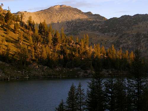
The South Navarre Campground (free) is really the only one in the south and is a few miles west of the Summer Blossom Trailhead on FR 8200. There are multiple campsites to the east at Crater Creek, Foggy Dew (not free) and Bear Camps. But really, there is no shortage of places to camp in the basins to the east and west of this peak. Water may be scarce for the first few miles of the trail from the south but in the basins there are year round streams and creeks. The best spot though would be to camp at Sunrise Lake on the north side of the peak (and east side of the Sawtooth Ridge). Multiple spots around the lake and few visitors.
Red Tape
When to Climb
July through September/October (or possibly later depending on when the snows start to fall)Mountain Conditions

Okanogan-Wenatchee National Forest
National Forest Headquarters
215 Melody Lane
Wenatchee, WA 98801
(509) 664-9200
Okanogan Valley Office
1240 South Second Avenue
Okanogan, WA 98840
(509) 826-3275
Road Conditions
Local Weather Information