
|
|
Route |
|---|---|
|
|
44.54400°N / 72.815°W |
|
|
Hiking |
|
|
Spring |
|
|
Half a day |
|
|
Class 1 |
|
|
Overview
The Sunset Ridge trail is considered one of the most scenic trails in Vermont, with the amount of time spent above treeline, water crossings and scenic outcroppings it is hard to disagree. Not only is the trail short but you get views of the Champlain Valley very quickly on the route.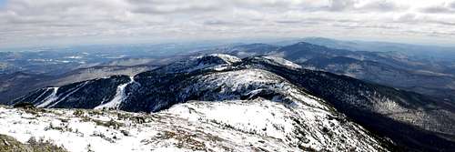
Getting There
The trailhead is located in Underhill State Park on the Northwest side of the mountain.from I-89N (North of Burlington) take exit VT-15E E ALLEN ST/ GRAND ARMY OF THE REPUBLIC HWY for 12 miles. Turn right on River Road follow for 6 miles, River Road will become Pleasant Valley Road. Follow Pleasant Valley Road for 2 miles to obvious parking.
Route Description
From Underhill Center parking follow the gravel road to the Underhill Ranger station. From the Ranger Station follow the CCC road or Eagle Cut trail to trailheads for Sunset Ridge and Laura Cowles trail (marked).The trails turns left into forest with bridge crossings over many streams. After a short hike you will reach the Cantilever Rock cutoff (0.2 miles to Cantilever Rock from trail). The trail starts switchbacks up the ridge and treeline is reached. Follow the blue blazes to the spine of Mansfield and head north to the Chin (4393ft)
Round Trip Length 6.6 Miles
Gain 2,600ft

Essential Gear
WaterWind Proof Layer
Good Shoes/Boots
Underhill State Park
Underhill State ParkPO Box 249
Underhill Center, Vermont 05490
Park Phone: 802-899-3022
Season: Memorial Day - Oct 15