
|
|
Route |
|---|---|
|
|
46.04581°N / 7.89576°E |
|
|
Mountaineering |
|
|
Spring, Summer, Fall, Winter |
|
|
Most of a day |
|
|
5.2 (YDS) |
|
|
AD, ZS |
|
|
II |
|
|
Overview
The Allalinhorn is a popular mountain, especially the normal route from Mittel Allalin (with the help of a cable-car and underground train). Furthermore many people use the Hohlaubgrat as an alternative to the light normal route. However, quite seldomly people go up the SW ridge which is considerably longer than the normal route up the Allalinhorn.This route is a nice option from both the Saas Fee as well as the Zermatt valley, as the route can be approached from both sides. It offers very beautiful scenic views on the Mellich glacier or Allalin glacier and a nice ridge climb on mediocre rock and snow towards the Summit.
A very nice alternative if you want to enjoy Allalinhorn while evading the large number of climbers on the normal route or hohlaubgratt.
Approach
 Traversing the slope after leaving the Glacier route towards the SW ridge
To climb the Allalinhorn over the SW ridge one can best start out at the Taschhuette or (somewhat longer) the Britanniahuette. From these hutts one can go over the Allphubel and Mellich glacier (Taschhuette) or the Allalinglacier (Brittaniahuette) towards the Allalinpass. On the map in the maps section below you can see how to reach the pass over the glacier.
When coming from the Taschhuette you don't need to go to the pass but can start the route somewhat before you reach the pass. When coming from the Britanniahuette you will recognise the SW ridge by a characteristic "horse head" which is visible in the lower part of the ridge just before you reach the Allalinpass.
The time taken to reach the start of the route is approximately 3-4 hours.
Given that there are crevaces it is necessary to use a rope when traversing the glaciers.
The route
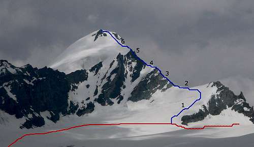 SW ridge route overview using the beautiful photograph 526472 by KoenVl.The route from the Taschhutt towards the Allalinpass is in red. The SW ridge route to Allalinhorn in blue with: 1) Snowy westface of SW ridge 2) Saddle 3) Rock grade II 4) Snow ridge 5)Gendarme (circumvented widely on the east (other) side) 6) Snow to the top
The route starts close to the Allalinpass (3564 m) somewhat in the direction of the Taschhuette. An image with the route drawn into it is shown on the right and a map with the route in blue is shown below in the maps section.
Route overview:
1) The route goes up by keeping on the right of the not so steep westface of the low part of the SW ridge (see photo right)
2) When you reach the SW ridge at the saddle (3730 m) you follow the ridge north towards the Allalin summit. The first rocks you will meet are quite grey in colour.
 the easy rock on the SW ridge
3) From there the rock part of the ridge starts, first easily, but later there are 3 so called "Aufschwunge", steeper parts of the ridge, approximately 10 meters in height and with climbing up to grade II. In between the "Aufschwunge" the rock is easier. At the "Aufschwunge" the route sometimes (on the 2nd "Aufschwung" according to the guide, if I remember correctly it was where the rock was more yellowish/brownish and not so much gray) goes a bit on the east of the ridge (just a few meters). It is easiest to follow the few crampon scratches on the rocks.
4) When the ridge flattens after the last "Aufschwung" you reach a section with some snow (which you can see on the photo on the left) with the Gendarmen (3921 m) in the background.
 Snow ridge with Gendarmen (3921 m) in the background.
5) After the snow you will see the Gendarmen (3921 m) towering above the ridge. The route first follows the easy rock on the ridge some more towards the Gendarmen. However it does not go over the Gendarmen but goes with a wide turn into the SE face to the east (right) of the Gendarmen. It can be difficult to find the route but generally the least steepest way up (after crossing approximately 50-100 meters in the SE face) should be doable (the rock is quoted as grade I).
 Last stretch of rock in the SE face before the snow starts.
6) When you reach the snow after the rock you will be able to look at the back of the Gendarmen. The route now continues over snow upward and connects to the normal route to reach the top.
The obvious descent is over the normal route towards mittel Allalin which can be done in 1-2 hours. From there you can use the transportation down towards Saas Fee.
Essential Gear
ropehelmet
good high alpine clothing
ice-axe and crampons
some slings or other protection for belay on rocky part of the ridge
Maps
A map with the route over the glacier to the Allalinpass: Route towards Allalinpass
A map with the route drawn onto it:
 SW Ridge route (blue). From the Britanniahuette to Allalinpass (green) and from Taschhuette (red).
External Links
To get free online maps of the area (and anywhere in Switzerland).The huts:
Britanniahutt
Taeschhutt