
|
|
Route |
|---|---|
|
|
48.25480°N / 120.8818°W |
|
|
Bushwhacking/Glacier Travel/Scrambling |
|
|
A long day |
|
|
Class 3 maximum |
|
|
Overview
Do you like brushing your teeth with liberal amounts of alder-flavored paste? Then this climb is for you.
While not technically difficult, there will be enough exasperation on approach that you'll be wondering why climbing ever took off in the Pacific Northwest.
Indeed, the first 5 hours or so will be spent just getting to the base of the mountain and the Dark Glacier. The next 3-5 (depending on conditions) will be spent climbing up the glacier to the summit. The glacier is large and breaks out in crevasse hives every summer. Yet, routefinding is apparently not an issue. It wasn't for us, but we did climb it when most crevasses except for the obvious ice fall ones were invisible.
 |
Swamp Creek "Trail" and Approach
From Swamp Creek Camp (see Main Page), take the abandoned trail southeastward up the forested hillside south of the creek. The trail tread can be hard to follow at times as it switchbacks a number of times in the first 800 vertical feet. The blowdowns in the way don't help. Keep keen for sawn logs and blazes. If you lose the trail, know that it begins contouring leftward into the Swamp Creek drainage proper after about 0.7 miles at maybe 3,700 ft (can't remember the exact elevation).
Follow the trail until it peters out at about 1.3 miles (c. 3,800 ft). Soon thereafter the south(west) side of the creek becomes quite brushy. A large alder fan looms ahead. At this point, when the trail is still in sparse woods, look to the creek to find a log to get across it. There were two big ones that I saw on the way out. The other side is still forest at this point. If you can't find those two logs, there are two (May 2005) inclined ones next to each other about 300 yards farther up the creek. 300 yards doesn't sound like a long way but we're talking alder yards. You will surely pass 30,000 yards of alder branches in that 300 yards of ground.
Once you get across the creek you may initially be able to relocate the abandoned trail in the forested sections. It parallels the creek about 100 yards away from the bank. But the trail soon disappears for good. Get out your handkerchief because soon you'll be crying as you fight your way through alder swath after alder swath.
The north(east) side of the creek in the middle part of the valley is a zebra-pattern of forest bands and alder swathes. I stopped counting swathes after eight. Some are troublesome, some are not. None are very wide. The forest isn't always an xylo-heaven either but it's still better. If you're diligent you may be able to avoid some alder swathes by moving up or down the slope to keep to woods. But this is easier said than done. You could waste a lot of time and energy doing this.
At about 4,100 ft where the word "Creek" is written on the map you can drop down to the creek to get your first view of Dark Peak in the distance still seeming like a long way off. It is. The lower basin waterfall may also be visible. Also at this point the slope steepens in forest. You can sidehill this forest to get to the lower basin or stay at the stream bank (the old trail might have been here). In between the two is ugly brush. I recommend going along the bank.
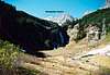
The Lower Basin Headwall
In about 4-5 hours from the Agnes Creek Trail you will reach the lower basin (c. 4,300 ft) with picturesque waterfall. The headwall looks formidable. The route up it is at far left. There is an appetizing forested cut up the wall right of the waterfall. Do not bite! To get your bearings and observe the correct route on the left side of the headwall, it is advisable to walk out into the basin to the creek to get a better view. From the east side of the basin, stay straight (south) and approach the headwall. A convenient sticker-bushed opening through thicker brush leads to a brushy gully on the left where the headwall corners. Take this brushy gully (sometimes with talus) upward for 200-300 vertical feet as it enters the larger trees higher up. A high-angle rock wall separates the smaller trees nearer the waterfall with the bigger trees higher up the slope. The idea is to go high enough up the gully until it is convenient to cut right up a slightly brushy, steep slope to gain the steep forest above and left of the rock wall. If you cut right too early you will be forced to climb the rock wall's low end in the trees (Class 3/4 but with suitable green belays).
Continue up the steep forest veering right at the end to a natural "saddle" (there was an orange piece of flagging guiding the way) at c. 5,040 ft. Just beyond this saddle the trees become small again. Crash through these small trees on a slight descent and reach the upper basin. Note: the middle of the basin could be boggy due to run-off thus necessitating an end-around to the left.
 |  |  |
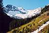
Dark Glacier Route
Once into the upper basin the glacier will present itself to you (unless it's a whiteout). On the far side of the basin is a third even higher minor basin (c. 5,500 ft) below the slabs of the receding glacier. A natural cut on the southwest side of that basin leads through the slabs to the glacier. In early season the cut will be easy snow. Later in season the cut may be a gully with stream necessitating an ascent over Class 2/3 slabs.
Our route used the far right side of the glacier. Other possibilities exist and will depend on when one visits. Crevasses will ultimately determine the most expeditious and/or least dangerous route. In a series of three "step-ups" we climbed up and left, up and left, up and left to reach the west spur of Dark at 8,200 ft east of the actual saddle.
Once on the spur, if the remainder of the ridge looks easy (uncorniced), leave the rope there and make for the summit. The first 200 yards or so to the final crest is up annoying flattened talus. The last 100 yards to the summit is along an exposed Class 2/3 crest (unless corniced) with many unbalanced rocks. Watch your step.
There is a cairn at the summit. Most of those who have signed in are the Top 100 lot.
Special note: Though it may look enticing from the glacier, do not ascend to the Northeast Ridge via the snow/talus slope under the north side of the summit. The final scramble along the Northeast Ridge is much more exposed and won't save you any time in the long run.
Time = 7-9 hours from Swamp Creek Camp on Agnes Creek Trail then 5-7 hours to get back to camp. The time required will depend on the environment's condition and your condition. If starting from Fivemile Camp add 2 hours round-trip. We did the climb from there in 16 hours camp-to-camp.
Distance = From Swamp Creek Camp it is about 6 miles, most of which is cross-country, a third of which is brushy. Add 3 more miles if starting from Fivemile Camp.
Gain = ~6,000 ft from Swamp Creek Camp, ~6,600 ft from Fivemile Camp (these include the necessary ups and downs to circumvent brush in the Swamp Creek drainage.
 |  |  |  |  |
Essential Gear
Glacier rope, glacier travel gear (ice axe, etc.)
Crampons--especially for later in the season. Lightweight ones would probably be okay.
Extra batteries for headlamp (or even an extra headlamp)
A good map (7.5-inch quadrangle) and compass
Please don't flag a route.
 |