Preface
I didn’t want to write this "trip report". But
Visentin created a new page, and it’s about a topic that I consider interesting. It’s about
Mountain Trips during Business Trips. He knowns that I’m interested in it, so he asked me to contribute to it. And I can’t resist, so I write about some of my business trip related adventures.
I’m sure that my stories will not be as interesting as the
Fuji story from
BorutKantuser, but still I try to summarize some of my stories. At least they have some extremities.
Linking business trips and mountain climbs creates a few constraints:
- Generally very limited time. Your business doesn’t pay you for climbing mountains. The business must be the first. Private activity cannot make any disadvantage for your company. You are lucky if you find a free weekend. But sometimes there are only a few hours of free slot. So there is success only with careful planning – and doing the tour in a hurry
- It’s rare that you do your business at a base camp in a mountain. Big cities are generally far from major mountains. So finding the destination is not easy
- To reach the trailhead you must use public transport. Generally with many changes
- Travelling with gear is not the easiest when you are on a business trip
- If you plan to start a long tour from the office on Friday evening, your colleagues can see you with mountaineering clothes on you – while the others are in normal office dress
There are also advantages in this combination:
- The cost of your trip from your home to the remote office is paid by the business. Sometimes even the week-end expenses are taken by the business
- You may visit such peaks that otherwise you would have never climbed...
- During business trips in most cases the alternative of mountaineering is just watching TV in a hotel room or going to a bar. I think it’s evident which one to choose, despite the difficulties
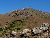
Hoh Brisen
![Brisen 2404m and Hoh Brisen 2413m]() The ridge between Brisen and Hoh Brisen
The ridge between Brisen and Hoh Brisen
It was in June 2003. I had a business trip to Paris. My last meeting was on Friday. And the next one was in Zug, in Switzerland on Monday morning. (The business trip in Zug was in order to design an EDI interface mapping and reading facility for an SQL based ERP system – Visentin surely will like this info ;)
So rather than going home to Hungary for the weekend I decided to go from Paris to Swizerland, enjoying the weekend in the Swiss Alps. On Saturday morning I left Paris and took a TGV to Geneve. I haven’t been there yet so I took the opportunity to visit the city. And on the other hand I expected to find a bookstore where tourist maps are sold. Yes, I found a map, and with the help of that I could identify an appropriate peak to climb. At this time there was not enough information on internet, so I couldn’t prepare proper plans. But the map helped. The famous mountains nearby the city Zug are
Rigi (1797 m) and Pilatus (2120 m). But there are many things where the bigger is better. It’s true for peaks, too. So rather than going to
Pilatus I selected the relatively unknown
Brisen that is 2404 m high.
On Sunday morning I left the hotel that is in the main square of Zug enough early, in order to reach the 6 a.m. train that took me to Lucerne. There I changed to the narrow gauge rack railway connecting Lucerne with Engelberg. I got off the train at the station Wolfenschiessen (being on 511 m ASL) intenting to walk up to the village called Oberrickebach. For a while I walked along the road. After a 30 minutes’ walk a car stoped and the kind driver asked me if he can take me up to the village. I said ‘no, thanks’ – I didn’t want to decrease my effort and my elevation gain record. So I continued my walk up to the village. Then up to the peak of Brisen. In these few words it sounds easy. But the temperature was around 30 Celsius (it cannot be ususal for the Swiss Alps), the elevation gain I had to do was 1900 m. And I didn’t have proper hiking "equipments" – just short pants and normal sports shoes. I was really tired by the time I was up on the peak of Brisen. But I cold see that there is a nearby peak called Hoh Brisen, 9 meter higher. I decided to go over there. No marked trail leaded over there. Just a sharp ridge, perhaps UIAA grade II-III. The wether was excellent, so why not to do it? After it I started my return to the train. In a mountain hut I ordered bear (not my habit to drink alcohol when hiking), but it was so hot during the whole day! The bear was warm, too, because the hut was not equipped with electricity and there was no fridge. Still it was better than nothing. Finally, after a long walk I was down at the train station via Niederrickenback. Then back to Lucerne. From Lucern back to Zug. The whole tour was 28 km. I had no sleeping problems on the night after.
I didn’t have any digital camera at this time, so rather than attaching my photos I attach one from
Cyrill (
Rest in Peace!).Höchst
This story is not about a peak but just about a hiking – still it has some extremity, so I share it with you.
It was in September 2008. I had a flight with transit from Budapest to Hong Kong through Frankfurt. The planned transit time was 3 hours. I prepared some maps copied from Google Map, in order to have a walk in the forests around the Frankfurt airport. In order to utilize the 3 hours. But when I landed in Frankfurt I could see that my flight is delayed by 7 hours. So I really had plenty of time. I took my hand luggage (laptop and a few other things). I decided to walk to the ancient city called Höchst. I had to cross a large forest, then on a bridge I crossed the river Main, and finally I was in the city centre of Höchst. After visiting the old city centre I returned to the airport on the same way, through the meadows and through the forest. It was a 15 km walk. Most people who were waiting for the same delayed flight were still in the same position on the seats as when I left the airport 3 hours earlier!
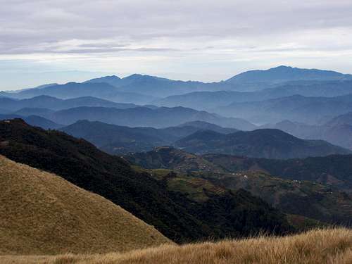
Tai Mo Shan
![View to west]() View to west from the peak
View to west from the peak
It’s another adventure in the transit time between flights. But this time in a really planned way. It was in November 2008. I had a flight with transit from Amsterdam to Manila through Hong Kong. I booked the flights in such a way that my transit time was enough long: I landed in HK in the morning, and planned to leave the airport in the evening. This made me possible to climb the highpoint –
Tai Mo Shan (957 m) - of Hong Kong.
If you consider Tai Mo Shan too small for climbing, find the lowest point and go up from there. A good option is to start the route from the
Tsuen Wan MTR Station. It is in elevation 20 m above see level. I accessed this station from the airport using the airport train, and then I changed to another underground line. It was not the easiest to find the ways. And when I asked help from the staff of the company operating the underground, it didn’t help much, because the best I could do is that I could identify that the small Chinese ladies spoke something similar to English, but their accent was so Chinese that I could hardly anything understand.
![Cemetery in the hillside]() The not too friendly hillside
The not too friendly hillside![The first military post on the top]() The not too friendly hillside
The not too friendly hillside![A local hiker]() A local hiker
A local hikerSo continuing the story, from the Tsuen Wan MTR Station I walked up the way to the village Chuen Lung (310 m above see level), 5 km far from the Tsuen Wan station. There is a pedestrian walkway along the Route Twisk, and the traffic is not too big, so it was safe and pleasant to walk up. From the village a new paved pedestrian walkway leads up to the cemetery (450 m ASL). Among the graves of the cemetery I ascended up to the ridge of the hill. On the ridge there is a hiking trail leading up to a military post (750 m ASL). It was written that the trail is dangerous and forbidden to use. But I didn’t take it seriously, so I continued my way. Using home-made maps of Google Map Satellite Views. After a while I reached a military post. The last hundred meters before the military post is so steep that the trail turns into a staircase here. Though the military post is in operation, I could bypass it without problems. 500 meter later I joined the main (and longer) road leading up to the peak. From this point I was not alone any more. Many local tourists coming from the nearby parking place were walking up here. Unfortunately the very top of the peak is occupied with a military basis, and it cannot be entered and visited. From the highest point that can be reached by a tourist a big part of HK, and also a nearby Chinese (mainland) metropolis can be well seen. I returned in a similar way as I ascended. The difference was that in the Chuen Lung village I had to enter a local restaurant to drink. I was extremely thirsty. Hong Kong – at least in this season – is warm, and the humidity is high. I did some preparations in order to have food and drink: I “saved” some small packages of peanuts from the plane as well as 500 ml water and a can of tomato juice. But 500 ml water cannot be enough for doing 930 m elevation gain and 15 km walk in this climate. And the tomato juice made it even worse: as it tuned out, it was not natural but hot and spicy. So I drank a liter of icy beer in the restaurant (Chinese beers are good) and another liter of water. It gave me enough energy to do another long walk in the downtown of HK in the afternoon. I returned to the airport in time and continued my way to Manila. The business was waiting for me.
Mt. Pulag
![Outlook to NW from Mt. Pulag]() The view from the peak
The view from the peak
I had to spend many weekends in Manila, Philippines. I often went to the mountains. In most cases alone, what was quite a challenge, as there are no maps in the Philippines. And many mountain ranges are covered with rain forest there.
Now I write about the most strenuous trip I did. It was in February 2009, to
Mt. Pulag. Mt Pulag is the highest peak (2922 m) of the huge island called Luzon. Manila is on this island. Mt. Pulag is also the second highest peak of the Philippines. The highest peak,
Mt. Apo is only a few meter higher (2954 m).
In all local trip reports it the tour to Mt. Pulag was described as 2 days going up to the summit and descending. So I had to prepare with stuff for 2 days: food, drink, camping gear, clothes, etc. My back-pack weighted 18 kg at departure. I left the hotel that was in Makati City (it belongs to Metro Manila) at 8 p.m., heading for the nearest metro station. Walking with to the station was already a challenge with the 18 kg – because the air humidity was 100%. It’s usual there. But walking people are not so much usual. People walking with an 18 kg pack are even less usual. At the station I met Joyce. Joyce is a small beautiful Chinese girl, who lives in Malaysia, but for a half year she worked in Manila on the same project as me. She had a similarly huge back-pack. The first action to do was to buy the metro ticket. We joined the queue of 200 people and after 25 minutes we had the tickets. Then we tried to enter the next train. It was not easy with those huge back-packs: all square cm of the train was already full. But we had to go – so we got in. After some 8 stops we got off at the bus station, and at 10 p.m. we were on the bus. These buses in the Philippines are comfortable buses. For sleeping they are not good, but otherwise they are OK. Though still they have some peculiarities:
- The aircon is always on, making 17 Celsius on the bus. That’s too low when otherwise you wear clothes for tropical weather
- In buses in long trips awful American movies are running in the bus, and very laudly
- The bus stops every 90 minutes, for a 20-25 minutes each time. The speed of the bus is very low, but it makes the average ever lower
- At each stop an army of moving snack sellers flood the board of the bus, selling "snacks" that only locals can identify what they are
So this was our bus, and in 7 hours we arrived to the "mountain capital" city called Baguio. Luckily we didn’t have any accident with the bus this time (on another similar trip our bus and a turck/trailer carrying patrol crashed our bus).
![The road going up to the ranger station above Ambangeg]() The jeepney with flat tire
The jeepney with flat tire
It was not yet 4 a.m. when we were already at the bus terminal in Baguio. There we met a local guy – Joyce’s friend. We planned to climb the mountain together. Our plan was to wait for the morning bus going near the trailhead. But that bus would departed 4 hours later. Luckily we met 2 groups of mountaineers on the terminal, both renting a jeepny. One of the groups allowed us to join them – there were free places on the jeepny yet.
What is a jeepny? It is a combination of a WWII jeep and a bus. From safety point of view it’s not conform with any European and US rules. You would think that it’s good for 10 passengers – but sometimes it carries 20 or even more people. I have seen a case when just in the driving cabin there were 4 people instead of the designed 2. Two passengers right to the driver and one left to the driver! Luggage is carried on the top of the jeepny, but in the countryside often passengers travel there, too.
So this was the jeepny we had. We travelled 2 hours through wild mountains, on a relatively good road. Then we arrived to the guest centre of the national park. We paid the entrance fees. And we had to participate on a 2 hours long education. It was about the national park and about the right behaviour in the national park (funny, isn’t it?).
Then we continued our trip on a 4x4 road – still with the jeepny. But now it was already different – we were properly educated! Soon we had a flat tire – it looked to be a usual thing, and the driver quickly replaced the wheel. After an hour’s travel we arrived to the so called Ranger House. The trailhead was here. It was a total 13 hours’ travel from the hotel to the trailhead!
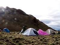
![Below the peak of Mt. Pulag]() Below the peak
Below the peak![Campsite 3 - Mt. Pulag]() The camp
The camp
[img:519228:alignright:small:Waiting for the sunrise]Now a few words about the team we joined. In the Philippines there are many enthusiastic mountaineers. It was a surprise for me, but they are really active on the net and in local mountaineering forums. Perhaps they represent only a fraction of a percentage of the total population, but as the population must be around 90 million (and growing by 5 million every year – with some exaggeration), even a small fraction can make a big absolute number. The members of the team had expensive mountaineering gears: Deuter backpacks, branded hiking boots. Most of them had watches with altitude meter. I expected them being near professionals. But when we started ascending, it turned out that they were not professionals at all. They were extremely slow. Their average speed was not more than 2 km per hours. It was very difficult for me to keep their speed. My average speed in easy mountains is 5 km per hour. For some hours I kept their speed. But there was a point when I lost my patience. Together with one of the mountain guides (there were 2 of them) I returned to "normal" pace, quickly reached the peak, then quickly arrived to the camping site. I mounted the tent and had a short sleep. Then in the next few hours the rest of the team arrived, too. The team members did everything very slowly: mounting tents slowly, eating slowly, making decisions slowly. They are in a different culture. For them surely I was strange: why I did everything in such a "hurry".
The night was very cold: it was not more than 5 Celsius. OK, the camping site was on 2800 m a.s.l. And it was the "winter" season in the Philippines. I couldn’t sleep much because of the cold. Luckily the team wanted to observe the sunrise from the peak of Mt. Pulag. So early morning – in full darkness – we got up and ascended the peak wit head-lamps. We were waiting for the sunrise during 90 minutes. The daylight arrived, but without any visible sunrise. The horizon was in clouds. No problem. We returned to the camp. I quickly packed everything together. (The others packed very slowly). This time I decided to descend in my pace, not waiting for them any more. I arrived a few hours earlier to the foothill. I had a good sleep. Then they arrived, too. And the return trip to the hotel in Manila - 13 hours – started. As much I remember I arrived to the hotel at 2 a.m. in the next morning. A few hours later I was in the office.
Not this was my only mountain trip in the Philippines but I had a few others:
- Mt. Maculot (not on SP yet)
-
Mt. Cristobal (1380 m)
-
Mt. Sto. Tomas (2256 m)
-
Mt. Singakalsa (2688 m)
-
Mt. Malipunyo (1005 m) – twice
Other Tours
Most of my business trips were to major cities, with really limited time. With no chance for mountains. At these places I hiked to seaides, lakes, forests, castles and churches. Most often early morning, before business hours. When I arrived to the office, normally I was already over a 8-10 km walk. I did many-many such walks in Morocco, Portugal, Spain, France, England, Belgium, Netherlands, Denmark, Norway, Sweden, Finland, Poland, Hungary, Romania, Turkey, Greece, Italy and Switzerland.
What Next?
In June 2010 I should organize a team meeting, in one of the Central/Eastern European countries. If possible, I try to organize it into Sofia. I think that
Vitosha is waiting for me.
PS: The meeting was successfully done. Organized into Borovec. It gave me the chance that in a 6 hours long pause I could summit Musala (2925 m), highpoint of Bulgaria!


Comments
Post a Comment