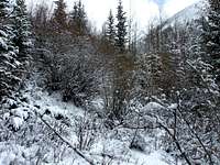
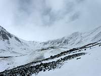
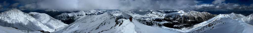
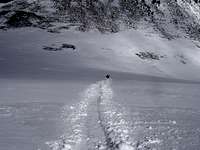
Tabeguache casts its own shadow

Tabeguache casts its own shadow

Page Type Page Type: Trip Report
Date Date Climbed/Hiked: May 15, 2010
Activities Activities: Hiking, Mountaineering, Scrambling, Canyoneering
Seasons Season: Spring, Winter

Prologue


Back in mid-April I climbed Mount Shavano with Dan and John. The route we chose was exhausting, and by the time we reached the summit we did not have the energy to continue over to Tabeguache. In retrospect I'm glad for this because, had we crossed the uninspiring saddle connecting Tabeguache with its higher neighbor to the east, we'd have robbed ourselves of an experience on this formidable mountain.

For two weeks following our success on Shavano I focused on other climbs, but Tabeguache was always there--truth be told I was apprehensive about returning and not particularly interested in any of the remaining standard routes over Mount Shavano. I'd seen others express the sentiment that Tabeguache Peak is little more than an afterthought when climbed via Mount Shavano, which is currently the only recommended route to its summit. I wanted to meet Tabeguache on its own terms.


1. Scheming


And so, nearly a month later, I found myself calling John to see if he was interested in a bid for Tabeguache. He was. I sent a message to Dan. Recovering from a marathon, he wasn't optimistic about joining us.

I wanted to try an approach from the south. The old standard route via Jennings Creek was closed in 2002 due to severe erosion on the hillside caused by heavy traffic and abuse on the trail, and I looked for alternatives; on Friday I found this excellent page by Aaron Johnson and suggested we follow a similar route, completely avoiding the old trail--including the trailhead. I sketched some route options on the GPS.


John was happy with this plan, and we agreed to meet at the Angel of Shavano Campground at 6 am Saturday morning. I sent Dan a note with our plans in case he changed his mind, packed up my gear, and left. Around 10 pm I arrived at the Angel campground and settled in for a fitful night. I slipped in and out of consciousness... At 5:30 the sound of John's truck pulling up to the gate wrested me out of limbo.


2. Another alpine start


John hadn't gotten much sleep either, but he was ready to go; his attitude was contagious, and soon I was just as enthusiastic to get started. We transferred his gear to my truck and continued down Co Rd 240, hoping to drive 4 mi to where we'd enter the Jennings Creek gulch. Covered by a thin layer of fresh snow, the road was easy driving.

We had traveled just 1 mi from the Angel campground when our juggernaut ground to a halt. A slanted wall of broken timber, earth, and snow blocked our advance; the road had been thoroughly overrun by a massive avalanche. We would have to continue on foot. We parked near the impasse at 9700' and geared up. It was 6:20 am. As we climbed over the debris, John remarked that he would bring a chainsaw next time.

barricade


It was a glorious morning. The warm glow of sunrise spread over the frosted trees and rocks on the hillside. Beneath its shadow the forest lay serene under a fresh blanket of snow. The stream chattered as it flowed alongside the road. Snow fell light and intermittent as we hiked and time and distance passed quickly in conversation.


In two hours we reached the old Jennings Creek trailhead, overgrown and unmarked in the snow. We continued another 0.3 mi down the road and started looking for a suitable point of entry, which we found near 10600', 2.9 mi from where we parked. I attempted to follow the GPS track I'd constructed earlier, but my routefinding was sloppy, and we bushwhacked through deadfall and thick undergrowth to 11000'. Here we emerged from the forest near Jennings Creek.


3. Jennings Creek


Jennings Creek gulch is a long corridor defined by two points, their ridges, and the saddle connecting them. Carbonate Mountain (13663') and its south ridge form the northwest corner and the west wall, respectively; the northeast corner is a prominent knob (13936') on Tabeguache's west ridge, and the ridge which extends south from it forms the eastern boundary. The gulch is gated at the far end by the saddle connecting Carbonate Mountain with point 13936. Our plan was to hike along Jennings Creek and climb up to Tabeguache's west ridge near this point.

looking out


We continued along the creek. Now and then a bitter wind swept down the gulch, bearing snow and ice crystals on its frigid breath. Twisted carcasses of trees once strong and defiant lay strewn across the hillside like mammoths perished by some ancient apocalypse. Now they ebbed in the unrelenting wind. Gray clouds sped by, shedding thin wisps as they scraped the ridges and broke, at intervals basking the mountainside in sunlight.


Soon we began to zig-zag up the moderate slopes below Tabeguache's west ridge and paused for a snack. We examined the saddle from our vantage point. On the left side there is a notch at 12600', and we decided to return that way and assess whether we had the energy to climb Carbonate. If not, we could glissade from the notch. Having agreed on this, we continued up to the ridge.

Tabeguache-Carbonate saddle

Carbonate Mountain


Jennings Creek gulch and Taylor Mountain


4. The void


Until now I had imagined we would come over the knob to see the summit nearby, a short hike along the ridge; so the view that greeted us at 13936' was peculiar--there was simply nothing. We had climbed into a void! Beyond the white crest of the knob there was only more white. I stood numbly, not wanting to turn around, afraid to discover we had come from nowhere, and that we had been nowhere all along.

the knob at 13936'


At length I consulted my GPS unit and was surprised to find we were still connected to where we had been by a thread of bread-crumb waypoints. My relief was profound; it seemed we weren't suddenly lost. "It's over there" I pointed into the void with certainty founded solely on the glowing screen of my device. We began exploring the knob, probing for a way down the other side, kicking steps in the crusty snow well away from a dark abyss to our left. The clouds thinned briefly, revealing a snowy ridge which resembled the blade of a hacksaw laid nearly flat, with its corniced teeth yawning over the abyss.


view of the summit


The summit was still a mystery, a series of contours on my screen we could get to by going that-a-way. As we descended along the ridge, I wondered aloud whether we would have any views from the top.

"Don't worry," John said confidently, "I'm in construction. It'll clear up."

Curiously (to me), he was right--after some minutes the ceiling lifted for the first time all day, and we got a glimpse of Tabeguache. The peak looked far away, further than our elevation of 13800' and the few remaining contour lines seemed to indicate. In fact we were still 0.5 mi from the summit. It was 2:15 pm. Encouraged nonetheless by the change in scenery and with the route ahead now fairly obvious, we moved at a quicker pace.

5. West ridge


We climbed over another hump on the ridge. Here the snow was soft and we installed our snowshoes. The skies continued to clear as we plodded along; like a herd of fat sheep the clouds shuffled away, huddling in a wooly mass to the west. Occasionally one would break from the flock and pass overhead, straying eastward to greener pastures. There the clouds grew dark and threatening, like black sheep brooding over the plains.


--I stopped counting sheep to take some photos of John approaching what I thought was, finally, the summit.


deceived again


But I joined him to find we still had another slope to climb. Here we encountered the crux of the route--a small rocky buttress which could be dismounted by lowering oneself along a jagged rock and passing through a notch at its base. Though it wasn't much of a crux, the ridge falling away steeply on both sides heightened the sense of exposure.


the crux


6. Summit


When at last we climbed onto the summit, we were elated. The views were everywhere spectacular and we took them all in, feeling we had earned every silent, snowy peak and corniced ridge which met our gaze. Our satisfaction with the route and the climb was full.


north

south

east

west

As we basked in the sunshine and relative calm, we discussed options for the descent. We'd already determined we wouldn't have the energy to climb Carbonate. I knew from studying the topo maps that the McCoy Creek drainage would funnel us back to the road; but I'd been unable to learn much else about it and made an assumption it was passable on foot. This would prove to be a mistake.


7. McCoy Creek


looking down the drainage


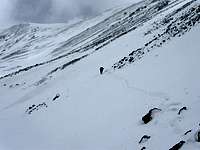
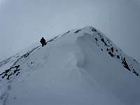
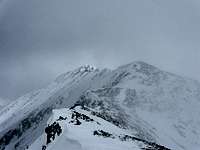
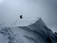
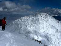
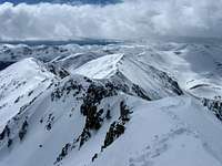
We both wanted to see more of the mountain and John, trusting my research, was agreeable to try a new route. And so, after a few more minutes enjoyed on the summit, at 3:45 pm we departed, stepping and sliding our way to the broad Shavano-Tabeguache saddle, where we began our descent to the drainage.

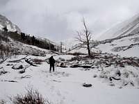
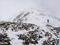
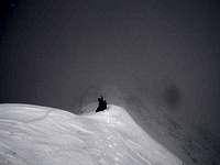
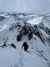
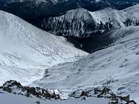
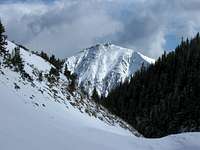
Higher up the snow was a mixture of wind crust and dense powder, and we were able to make quick work of several hundred feet by a series of short, jarring glissades each ending abruptly with a whumph and flying snow. Below 13200', however, the powder baking in the hot afternoon sun had become heavy and wet. Further attempts to glissade or even plunge-step resulted in 6" - 8" deep slabs breaking away from the underlying hard pack and dispatched them sliding and tumbling downhill. Fear of triggering a big one forced us to traverse onto the southwest face of Mount Shavano, where we could follow patches of tundra poking up through the snow and loose rock down to the drainage.


On reaching the bottom we were treated to impressive views of Tabeguache Peak and Mount Shavano towering over 2000' above us and wondered how many others have been privileged to see them from this perspective.


Lost Mountain

The changes in scenery continued to amaze as we proceeded along the drainage, which became a ravine with complex rock walls rising on both sides, at first like huge three-dimensional jigsaw puzzles, but growing more slabby as we descended. The snow blanketing McCoy Creek began to thin, requiring care to avoid stepping through to the icy water below. As the ravine narrowed, it became impossible to bypass the thin spots. Hoping to achieve better flotation, we installed our snowshoes again.


The constant sound of rushing water reminded us of our proximity to an unwanted bath. Wet graupel started to rain down. This was taking longer than expected, and I grew impatient, frustrated, and--as the walls closed in--increasingly worried we'd get stuck.


These fears were justified when we came to a drop near 10700'. The creek poured down a smooth concavity and pooled chaotically at the bottom before cascading around a bend, out of sight. The drop was about 10 feet and slippery. At best we'd get very wet. I looked for a way around. To the left a wall rose straight up 80 feet; to the right, huge slabs anchored the towering walls of the ravine and angled steeply to the creek below. It looked half-possible to navigate down some ledges here, but any fall would mean serious injury and all the rock was now wet from the fast-melting graupel. There would be no climbing back up. If we were to encounter further difficulties around the bend, then what?

"We can't go this way!" I hollered back to John, staring miserably into the pool below. "I don't know what to do." The prospect of going all the way back up the ravine was more than daunting. I was losing my cool.

"What about this, do you think there's a way down the other side?" John indicated a steep chute bisecting the cliffs to our left. It was a narrow, sustained gully filled with loose, gravelly rock and snow and dotted with evergreen trees, leading up 100' above the creek. I consulted the GPS. If we could climb that gully and gain the ridge, it certainly looked like we'd be able to bypass the cliffs to the south and escape over more gradual slopes on the east side.

"I think so, yeah."

So we climbed the gully, using the trees to brace and pull ourselves up. Soon we were high above the creek. Scrambling out of the chute, we found the way to the south entirely impassable, as expected. Furthermore, we were still below some of the hard terrain and would have to climb higher on the ridge. It was nearly 7 pm now; precious little daylight remained for route-finding.

climbing out of the gully

This was new. "I think I'm freaking out," I told John. He was unruffled. Did I have any matches or a lighter? No. Warm layers? Yes. Food and water? Enough. It might be a cold night on the mountain, but we'd be fine. John's voice betrayed no disquiet, and his calmness shored up my faltering composure.


8. Escape


We continued to scramble to the east, checking the GPS every so often to maintain our distance above the cliffs. Finally I decided we had cleared them and could safely make our way down. John led the descent on steep but manageable terrain which gradually spilled into a thick forest bordering the road. I felt deeply relieved and also foolish for having let circumstances get the better of me. As we picked our way through the brush and deadfall I thanked John for keeping it together.

view of Lost Mountain as we find a way down

We emerged onto the road just as the sun dipped below the hills. Hiking down 240 I worked out my lessons from the day, concluding it best not to attempt descending a way we hadn't climbed without first knowing whether it is passable, given our equipment (we were not carrying rope). Although we conceded to this, neither John nor I regretted having done it. The thought of missing out on what we had seen was dismaying. We had met the mountain on its own terms and respected it the more--Tabeguache Peak certainly deserves better than the standard route over Mount Shavano.

END


Some notes


It is such a pleasure to climb with John. As a mountaineer, his ability matches his dauntless enthusiasm, courage, and patience. These are surpassed only by his love for the mountains. His simple articulation of the joy of these high places couldn't be more precise, and he has a way of putting things into perspective which inspires confidence and testifies to the breadth of his wisdom and experience. I have the highest respect for him, and it goes without saying I couldn't have had a better partner on this one.

Lastly, I regret Dan wasn't able to join us. We are certainly sad to see him leave Colorado (for now). Hurry back--these mountains won't be here forever!

John and Dan on Shavano


Appendix


GPS track

GPS profile


Comments

Post a Comment
Viewing: 1-2 of 2
T Mac

T Mac - Jul 14, 2010 1:39 pm - Voted 10/10

Good stuff

"...foolish for having let circumstances get the better of me" - I sure know that feeling after getting though a hike.

metal4lyf

metal4lyf - Jul 14, 2010 5:06 pm - Hasn't voted

Re: Good stuff

haha, it wouldn't have been the first time, although usually no one else is around

Viewing: 1-2 of 2

Children

Children

Children refers to the set of objects that logically fall under a given object. For example, the Aconcagua mountain page is a child of the 'Aconcagua Group' and the 'Seven Summits.' The Aconcagua mountain itself has many routes, photos, and trip reports as children.

Parents 

Parents

Parents refers to a larger category under which an object falls. For example, theAconcagua mountain page has the 'Aconcagua Group' and the 'Seven Summits' asparents and is a parent itself to many routes, photos, and Trip Reports.

Tabeguache PeakTrip Reports