
-
 3455 Hits
-
 71.06% Score
-
 1 Votes
|
|
Route |
|---|---|
|
|
42.83180°N / 0.7528°W |
|
|
Scramble |
|
|
Half a day |
|
|
SD/F (Walk-up) |
|
|
Approach
See the main page.Route Description
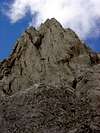
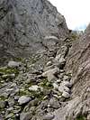
In the little park of Tacheras we see the bridge to cross the river with the track. Initially we follow the track but is possible if you know the zone to leave the track and to go across the paths in the forest (cairns). The track go to a zone with 2 great ships of cattle with the red roof. In a few meters we leave the track to the evident path to the great rock of Achar de Alano, in front of us. The path follow directly to the left side of Achar. We have discovered finally the point of entry of the Sierra de Alanos that from below seemed to be difficult to cross. The step-crossing is a way across big blocks of stone that without difficulties go to the great green plain that hides itself after the saw, is the Foya de Alano.Still we don't see the summit but we must look for the way to the left side (east) that takes us to a karstic zone of rocks. This zone is indicated with cairns though in days of fog we can get lost with facility.
The normal route is the continuation to the visible col between the Rinc�n de Alano (left, north) and Pe�a Forca (right, south). The Rinc�n de Alano is the last peak of the left side (very different from the rocky steep aspect that has the north face). Near the col we leave the way to Pe�a Forca and we go to the green ramp of Rinc�n to the summit. Enjoy the great views! Generally 3h30min or 4h to the summit.
Another posibility: in the middle of the karstic zone you can see a little path in the hillside of stones in the left side to the Punta Mazandú (2222m) and for the ridge we can reach the summit of Rinc�n across little summits without name.
After the summit is a good idea to reach the peak of Peña Forca (2391m), the highest point of the range. The route go to the col and we can reach the summit (you can see the orientative geodesic vertex) for a evident orange channel or across the ridge with the eastern summit in the left side.
 |  |  |  |  |
Essential Gear
Nothing special.In winter crampons and ice-axe. If you continue in winter or with snow to Peña Forca is a good idea the rope for the ridge (very exposed).