
|
|
Area/Range |
|---|---|
|
|
36.37680°N / 50.96190°E |
|
|
Hiking, Mountaineering, Sport Climbing, Bouldering, Ice Climbing, Big Wall, Mixed, Scrambling, Canyoneering, Skiing |
|
|
Spring, Summer, Fall |
|
|
15912 ft / 4850 m |
|
|
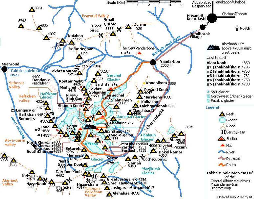
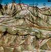
Overview
Click for Introduction to Central Alborz Mountains
Click for Nader's map of Takhte Soleyman Massif
Click for map of Central Alborz.
Click for aerial photo of a portion of the Takhte Soleyman Massif
 |
| Alborz (Elburz or Alburz) mountain range, north Iran, between the Caspian sea and the central Iranian plateau consists of steep, narrow, parallel ridges, the northern slopes of the Alborz are rainy and forested, the southern slope is semiarid. Alborz range is generally divided into west, middle and east Alborz. At the north-west part of the middle Alborz, some jagged, rugged and not parallel ridge lines form a sub-range that contains about 160 distinct peaks higher than 4000m, called Takht-e-Soleiman massif. The area can be captured inside a rectangle (30km width, 40km height). Because of being close to the Caspian sea the humidity of the area is high so usually it's not easy to have a good view from nearby places even if the whole place is not captured in a thick fog. Some granite mine works near the massif is the worst fact of the place, and gives the sense of destroying it's great nature. One more bad thing is that there is no mobile service coverage over the area. |
| Discovery |
| The Takht-e-Soleiman region was unknown until 1933. Douglas Busk, a British mountaineer, discovered and surveyed the area. Later on, Busk along with Professor Bobek made a detailed survey of this area. In 1936 the north-west ridge (called Germans flank) of Alamkooh was climbed for the first time by German mountaineers, which was considered a great achievement among European climbers. |
 |  |  |  |  |
4000m+ Peaks
| Peak name | Height (m) | Start point | Peak name | Height (m) | Start point | Peak name | Height (m) | Start point |
| Alamkooh | 4850 | (2) | Menareh | 4378 | (4) | Gordeh kouh | 4140 | (5) |
| Shakhak(horn)#1 | 4795 | (2) | Haftkhan14 | 4376 | (6) | Korma | 4020 | (0) |
| Shakhak(horn)#2 | 4750 | (2) | South Siahgoug3 | 4360 | (1) | Sarchal lashgarak | 4120 | (12) |
| Shakhak(horn)#3 | 4782 | (3) | East Qobi | 4359 | (5) | Haftkhan19 | 4120 | (6) |
| Shakhak(horn)#4 | 4750 | (2) | Takht-e-Rostam | 4350 | (5) | Mishchal | 4104 | (5) |
| North Khersan | 4680 | (2) | Mian-se-Chal | 4348 | (2) | Naft chauk | 4100 | (7) |
| Shakhak(horn)#5 | 4700 | (3) | Mishchal2 | 4340 | (1) | Chartapi abeedar2 | 4100 | (8) |
| South Khersan | 4659 | (4) | N. Gadoun kouh | 4338 | (4) | Lez abeedar | 4100 | (0) |
| Takht-e-Soleiman | 4659 | (1) | Tang-e-Galoo | 4335 | (3) | Takht-e-Soleiman7 | 4100 | (1) |
| Middle Khersan | 4620 | (3) | Haftkhan9 | 4329 | (6) | Haftkhan15 | 4100 | (6) |
| Viran kouh | 4609 | (3) | Misan-se-chal3 | 4325 | (2) | Haftkhan18 | 4100 | (6) |
| Siah sang | 4604 | (2) | Haftkhan17 | 4324 | (6) | Haftkhan2 | 4100 | (6) |
| Split | 4600 | (2) | Siah quar | 4320 | (5) | Lovie nua | 4100 | (9) |
| Marjikesh | 4580 | (3) | Hezar cham | 4317 | (4) | Muazi gardan | 4087 | (9) |
| Haftkhan1 | 4537 | (4) | Mian-se-chal2 | 4316 | (2) | Sare muaz gardan | 4085 | (9) |
| Marjikesh2 | 4533 | (3) | Tang-e-Galoo2 | 4310 | (1) | Sekonj | 4080 | (8) |
| Haftkhan2 (Lana) | 4528 | (4) | Setareh2 | 4300 | (4) | Kelvan | 4078 | (11) |
| Chaloun1 | 4516 | (2) | Haftkhan16 | 4300 | (6) | Marsheno2 | 4074 | (0) |
| Siah kaman | 4472 | (2) | Tang-e-Galoo3 | 4280 | (3) | Mishchal | 4067 | (11) |
| Negin2 | 4500 | (2) | Haftkhan12 | 4270 | (6) | Muazi gardan3 | 4062 | (9) |
| Takht-e-Soleiman2 | 4500 | (1) | Mishvar | 4267 | (5) | Muazi gardan2 | 4060 | (9) |
| Takht-e-Soleiman5 | 4500 | (1) | Ab(v)eedar | 4260 | (8) | Do kaleh kamar | 4060 | (8) |
| South Siahgoug | 4500 | (1) | Gale gardanak | 4260 | (7) | Siah kamar | 4060 | (3) |
| Rostam nish | 4500 | (1) | Great Lashgarak | 4256 | (4) | Doozeh kouh | 4050 | (10) |
| Haftkhan3 | 4500 | (4) | Haftkhan11 | 4250 | (6) | Alanehrsar | 4050 | (8) |
| Clauch band | 4480 | (7) | Sar sasped3 | 4237 | (1) | Kelvan4 | 4050 | (11) |
| Small Chaloun | 4480 | (2) | Setareh | 4240 | (4) | Nezar | 4078 | (11) |
| Takht-e-Soleiman3 | 4480 | (1) | Zard gel2 | 4231 | (3) | Mishchal4 | 4044 | (11) |
| Shaneh kouh | 4465 | (2) | Takht-e-Marjikesh | 4214 | (3) | Mishchal3 | 4042 | (11) |
| Haftkhan4 | 4457 | (4) | Kal bazuan | 4200 | (7) | Khoshkdar | 4040 | (0) |
| Takht-e-Soleiman4 | 4453 | (1) | Zard gel | 4200 | (3) | Kelvan2 | 4040 | (11) |
| Takht-e-Soleiman8 | 4450 | (1) | Zarrin kouh | 4200 | (8) | Haftkhan10 | 4040 | (6) |
| Haftkhan5 | 4450 | (4) | Chartapi abeedar | 4200 | (8) | Haftkhan21 | 4040 | (6) |
| Chaloun2 | 4450 | (2) | South's Siahgug | 4200 | (1) | Mishchal6 | 4028 | (11) |
| North Siahgoug | 4445 | (1) | Haftkhan8 | 4200 | (6) | Mishchal5 | 4023 | (11) |
| Haftkhan6 | 4440 | (4) | Haftkhan13 | 4200 | (6) | Kelvan3 | 4023 | (11) |
| Chaloun3 | 4440 | (2) | Magas nafar | 4200 | (5) | Harkate garan | 4020 | (8) |
| Negin | 4440 | (2) | Kalchal | 4200 | (9) | LashgarakSarband | 4017 | (8) |
| South Siahgoug7 | 4430 | (1) | Siah let | 4200 | (5) | Divchalkhoshakesh | 4012 | (14) |
| Dandan-e-Ejdeha | 4420 | (1) | Nefar Neqar | 4199 | (5) | Masmoor | 4012 | (15) |
| South Siahgoug8 | 4418 | (1) | Chartapi abeedar3 | 4190 | (8) | Siah kaloo | 4010 | (8) |
| Mishchal | 4410 | (1) | Divchal | 4185 | (8) | Mishchal2 | 4008 | (4) |
| Kalahoo | 4412 | (5) | Small Lashgarak | 4184 | (8) | Espeed | 4000 | (1) |
| Gardoun kouh | 4402 | (4) | Chartapi abeedar | 4184 | (8) | Haftkhan22 | 4000 | (6) |
| Kaljaran | 4400 | (5) | Takht-e-Soleiman6 | 4180 | (1) | Pasand kouh | 4074 | (0) |
| South Siahgug2 | 4400 | (1) | Siah lat | 4180 | (5) | Marsheno | 4000 | (7) |
| Takht-e-Soleiman9 | 4400 | (1) | Pit quar | 4180 | (5) | Sardasht | 4000 | (3) |
| Shaneh kouh2 | 4400 | (1) | Sarchal divchal | 4150 | (8) | Delzoor | 4000 | (8) |
| West Qobi | 4399 | (5) | South Siahgug5 | 4150 | (1) | Takht-e-Khers | 4000 | (8) |
| Haftkhan7 | 4389 | (4) | Siah kamar | 4140 | (3) | |||
| * What are the numbers under "Start point" column? match them with the numbers in the "Getting there" section of the page. | ||||||||
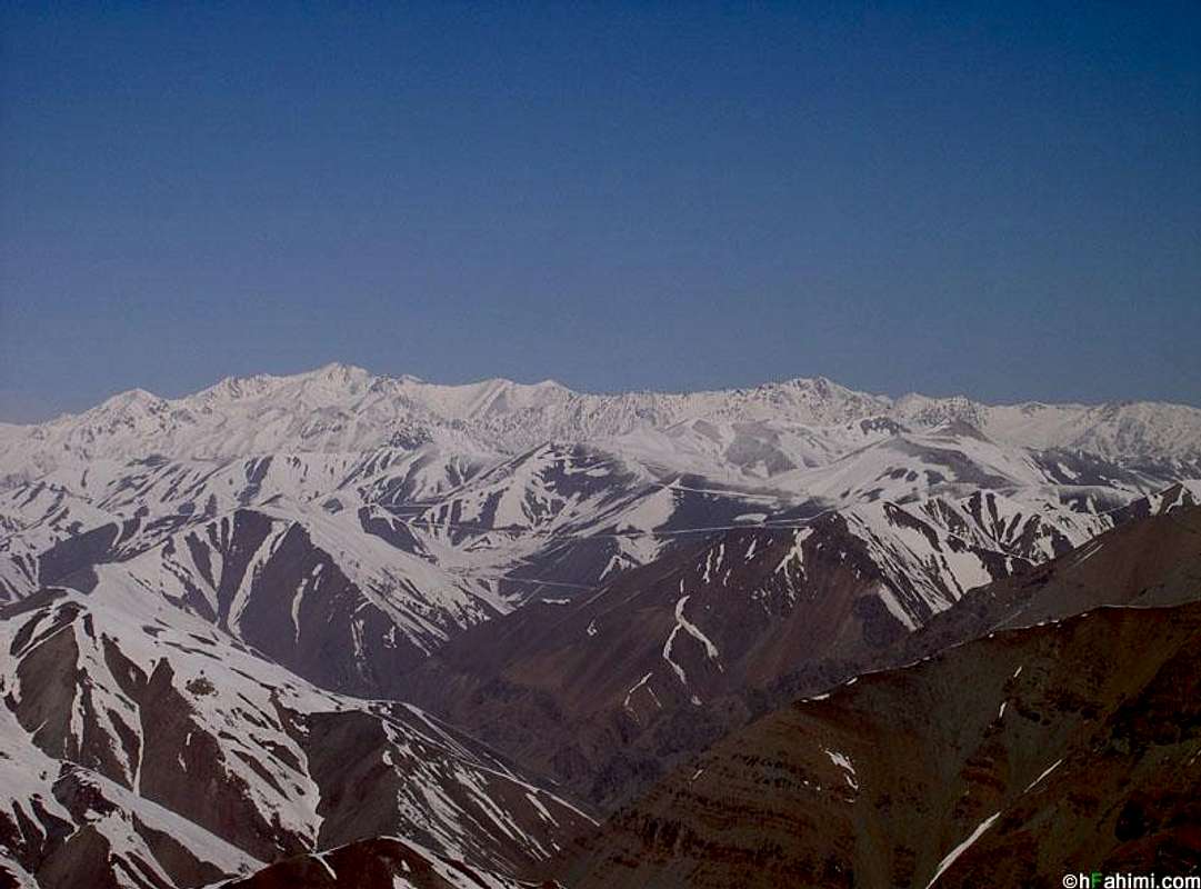
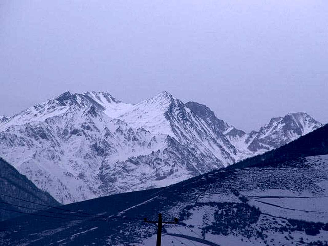 Jan 2005 highest: Pasanskouh(4000m) left front - Siahkaman(4472m) middle - Alamkouh(4850m) the black stone behind Siahkaman - Takht-e-Soleiman(4659m) very right | ||||||||
Objects
| Major glaciers | ||||||||||||||||||||||||||||||||||||||||
| ||||||||||||||||||||||||||||||||||||||||
| Shelters and huts | ||||||||||||||||||||||||||||||||||||||||
| ||||||||||||||||||||||||||||||||||||||||
| Most known impressive walls | ||||||||||||||||||||||||||||||||||||||||
| ||||||||||||||||||||||||||||||||||||||||
| About names if you are interested | ||||||||||||||||||||||||||||||||||||||||
| kouh=mountain, shakhak=horn, chal=pit, takht=bed, soleiman=solomon, siah=black, sang=stone, khers=bear |
Getting There
Leaving Roudbarak to the mountains...
Acording to the desired climbing region/peak these are the starting points:(see maps included on this page, it's recommended to supply a big map from Tehran with this title "Middle Alborz, by Gita shenasy", price less than 1$)
- Roudbarak (The most known starting point for the massif)
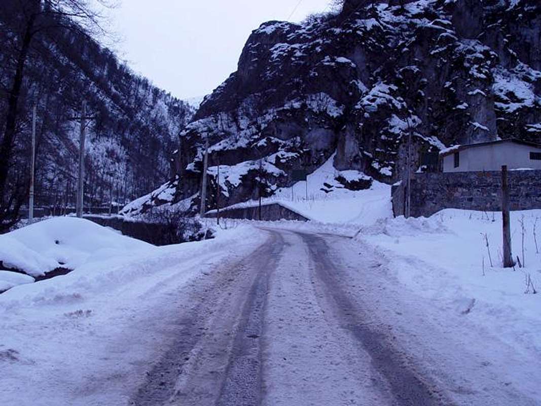
Tehran -> Karaj (by a 30Km highway) -> Karaj-Chalous road(a lovely writhen road inside Alborz range), 24Km before Chalous at Marzanabad village turn left toward Kelardasht -> Hasankif(green vegetated plane) -> Roudbarak village(1400m).
From north Iran: reach Abbasabad city near Tonekabon city, a fantastic road would take you to Kelardasht in 45 mins. you can see the lush valleys, hills and huge rocks that gently turn into Alborz high mountains, the caspian see and the Takht-e-Soleiman massif at a glance from this road.(0) - Vandarbon - at the end of Roudbarak there is a dirt road, after about 8Km(40minutes by car) it reaches Vandarbon(2100m)
(1) - Sarchal - at Vandarbon there is a 2way there is an indicating sign that shows the way: go right position, there is a narrow way beside the river that reaches Sarchal(3850m) it's about 4 hours walking
(2) - Alamchal - about 2 hours walking from Sarchal you will reach Alamchal(4100m~4170m)
(3) - Hesarchal - from Vandarbon indicating sign, go left after a long walk you reach Hesarchal(4000m)
(5) - Kaljaran - before reaching Sarchal there is a 2way, right position reaches Kaljaran
(10) - Lizounak - before reaching Sarchal-shelter
(14) - Khoshakesh - from Roudbarak area you should go south to a valley called Khoshakesh
(7) - Naftchauk - it's the vally between Siahkaman-Chaloun ridge line and PasandKouh-Chaloun ridge line, reach there from Vandarbon - Sarchal way - Taleqan-Parachan
Starting point fot climbing south parts of the massif, many ways to reach Telegan area, see the middle Alborz map
(4) Taleqan-Parachan-Hezarcham
(11) Taleqan-Parachan-Domcheh
- Shasavar-Seheza
Starting point fot climbing east parts of the massif, from Chalous city go to Tonekabon city on the seaside road, find the river called 3000, go on the road beside the river (south) - follow the dirt road to reach 'Qazi Mahalle' ...
(6) Shasavar-Sehezar-Mianroud - from Qazi Mahalle go west
(9) Shasavar-Sehezar-Auroud - from Qazi Mahalle go south
- Dalir (8)
On Karaj-Chalous road(see Roudbarak) 41Km before Chalous is 'Dozdband 2 way', go left(west) to Elit and then Dalir villages
(12) Gardaneye Dochak - from Dalir walk to east to the cervix called Dochak
- Nater (15)
On Karaj-Chalous road(see Roudbarak) 37Km before Chalous is 'Makaroud 2 way', go left(west) to Nater village
 |  |  |  |  |
Red Tape and Regional Hints
| The whole Alborz mountains area and it's wild nature is a protected place, hunting, fishing and abusing the nature is prohibited |
| No fees of permission is required for climbing or camping |
| No problem for camping but avalanche danger ! |
| Karaj-Chalous road becomes 1way at 6.30pm on summer Fridays and Iranian holidays so cars can only drive to Tehran. |
| Numerous rock falls and avalanches, frostbite, getting lost, wild animals... ! so get enough prepared and informed about the region by the locals specially at 'Roudbarak Iran Federation of Mountaineering Hotel(IFM)' or hire a local to come with you. |
| Report your entrance to the region and the time you want to spend on the massif to the 'Roudbarak Iran Federation of Mountaineering Hotel (IFM)' or the locals before performing a climb, so they would send rescue if you are late. |
When To Climb
| Best | For Haftkhan peaks is early August, for central parts is July-August, For east and outer parts is late June |
| Photography | Late spring, the place looks great green including thin clear air and lots of snow on the mountains, a sunny winter day after a snowfall is the best, usually the fog and humidity are the restricts to get a good view. |
| Summer | Sarchal hut may be crowded, numerous minor and some major rock falls happen often, and can cause changes in the routes or be deadly. Anyway you can do the easiest hikes and climbs in summer. |
| Winter | Heavy snow and ice, frequent unexpected storms may last days. It would be a tough and technical attempt, requires technical winter equipments and you must know the region well, specially for Haftkhan peaks it might be the hardest attempt of the whole Alborz. |
Camping
No fees, no permition, but be ware of the avalenches and rock falls before camping.Links and Books
| Links | National Geoscience Database Of IRAN, This site includes great geo. informations about Persia, and it's mountain ranges, in English and Persian (www.ngdir.ir )[GO] |
| You can find lots of 3D maps of Tehran, and parts of Elborz mountains above it and active fault lines of Elborz [GO] | |
| Some routes on the Alamkouh wall (Persian) [GO] | |
| www.parsoon.com/alamkouh.htm [GO] | |
| About Alamkouh wall and a new route opening report in winter of 1991 (English)[GO] | |
| A Woman attempt report (English) [GO] | |
| Books | Mountaineering in Iran (Koohnavardi dar Iran) in Persian, by Ali Moqim This book is a good guid including maps,routes, conditions... and any basic information you need for climbing mountains of Iran, also includes a list of books about mountaineering in Iran. |
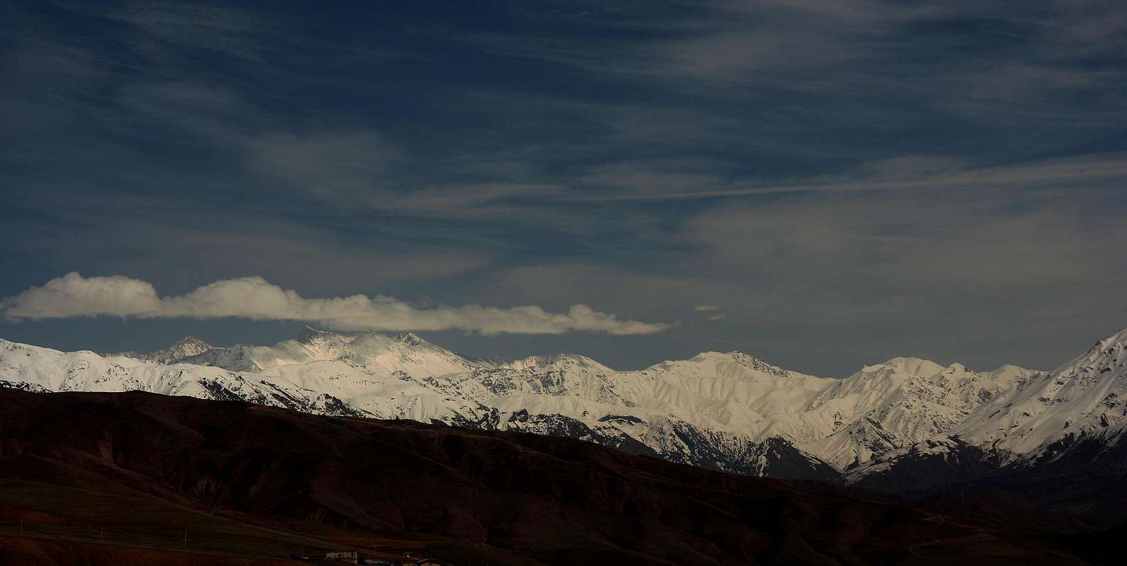
A fine picture showing Takht-e-Soleiman massif south face, early spring. Alamkooh is the highest point in the center. Picture taken at Dizin Ski resort "Upper parking" (3200m) and about 80Km far.
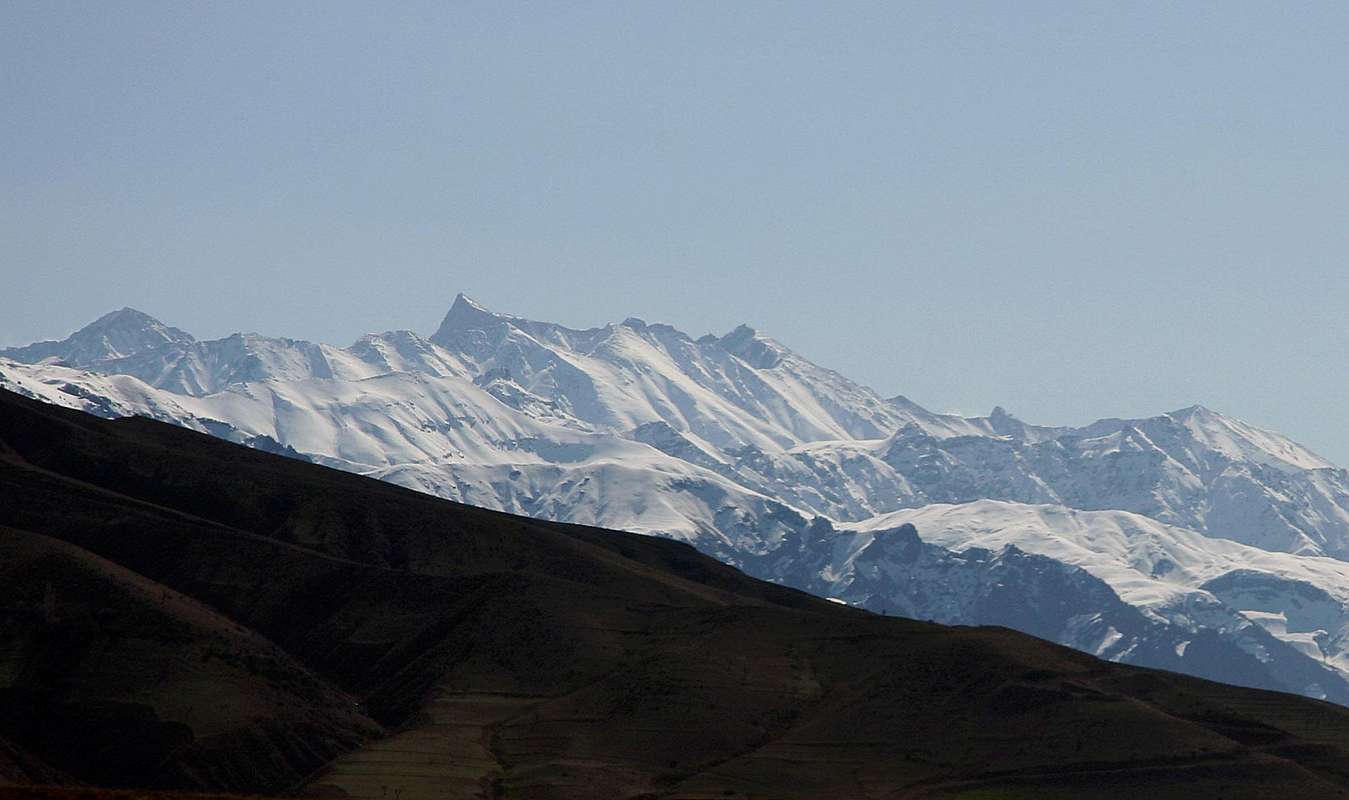
Two pictures taken from Alamoot covering the west face of the massif, click to see the details and the original sized picture to be able to find Alamkooh horn, Takht-e-Soleiman peak, the Haftkhan peaks, Khersans, Menare, Gardoon kooh...
Skiing
Dizin and other Irainian ski resorts become unusable at may.While some areas like Takht-e-Soleiman massif and Damavand still contain skiable snow on the higher glaciers and parts of the mountains even till mid summer, fortunately there is no ski lines and elevators installed in these places so this places are still not crowded and ... but I have heard that some Dizin locals carry their ski equipments up the massif and ski at summer.