
|
|
Mountain/Rock |
|---|---|
|
|
22.05892°S / 44.67254°W |
|
|
Aiuruoca |
|
|
Hiking, Mountaineering, Scrambling |
|
|
Fall, Winter |
|
|
7464 ft / 2275 m |
|
|
Overview
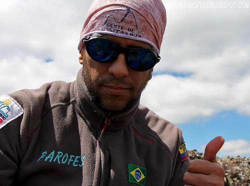
Oct 11, 2013. Summit.
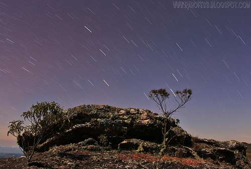
My bivy spot.10 minutes of exposure to get this cool star trail.
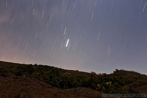
This one I did 15 minutes.
Tamanduá-Bandeira Hill or Peak is 2.275 meters high, (7,464 feet), and offers a breathtaking view to several of these high brazilian peaks, all of them higher than 2.400m of altitude.
Never got to find the reason for it's name and even for it's second name: First name: Tamanduá Bandeira (animal: Myrmecopha gatridactyla), maybe some of them can be seen over the mountain and it's flanks, really don't know. Talked to some locals but no reason was given to me. The second name: Pico do Gamarra: Another mistery, several locals not even know about this other nomination for the highest summit of this reagion and a 50kms terrain domination. The most probable reason is for the number of animals like this been seen on the mountain since the Tamanduá-Bandeira can be found in almost all Brazil land except Rio Grande o Sul state and Espirito Santo state.
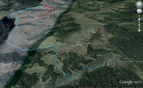
From it’s top, it’s possible to see all the traverse route which begins on Papagaio Peak on the extreme east of the Serra, and crosses (over the main ridge from peak to peak) around five kms, and in total something around 15kms of a light but scenic traverse with several water founts, creeks to cross, amazing wildlife observation, and a clear sky if done in winter time of course. The peaks of this traverse are Papagaio Peak (2.105m/6,906ft) and Tamanduá Bandeira Peak (2.275m/ 7,464ft), each in it’s extreme point of the traverse. East and west.
While hiking absolutely alone in the Serra between October 11th and October 12th of 2013, I could observe a great deal of wildlife which cannot be seen in several other points along Mantiqueira, with a lot more people, a fact that scares away wildlife for sure: I saw eagles, several of them, at least 8 individuals, Urubú de cabeça preta (Coragyps atratus), Urubú Rei (Sarcoramphus papa), Araçari Banana (Pteroglossus bailloni), several spiders of several sizes and species, and a very curious Jacarambeva (Conepatus semistriatus) came to smell my sleeping bag at 9:00pm while I was inside it holding my remote control doing a night long exposure shot! Hehehe…by far the funniest close encounter I have ever had with wildlife.
Besides these, one can observe also the feared Onça Pintada (Panthera onca), Onça Parda aka as Suçuarana (Puma Concolor), LoboGuará (Chrysocyon brachyurus), Jaguatirica (Leopardus pardalis). But, of course, due to its nocturnal activities and necessity to avoid contact with humans, these are rarely spotted over the Serra. Sometimes reports of attack with human fatalities are reported all over the news, always by the Onça, a great cat that has been neglected by humans losing its territory to farmers more and more each year.
Getting There
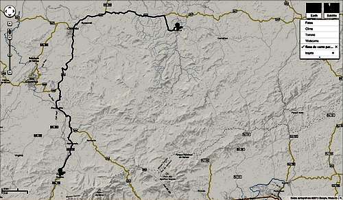
Road informational image
From São Paulo, bus towards Caxambú county (Tietê bus terminal – price is R$ 54,55 – around US$ 23.00 – it takes 6h30min).
That can be with viação Cometa (http://www.viacaocometa.com.br/pt/). From there get a second bus to Aiuruoca (same bus terminal – R$ 13,55 around US$ 5.5 – it takes one hour more), or a taxi ride since there’s just one bus leaving the city per day (that would be pretty expensive, around R$ 80,00). Phone: 55 + 11 + 4004-9600.
From Rio de Janeiro get a bus to Caxambu the same way (Novo Rio bus terminal – price is R$ 53,47 – around US$ 22.00 – it takes 5h30min). From there get a second bus to Aiuruoca (same bus terminal – R$13,55 around US$ 5.5 – it takes one hour more), or a taxi ride since there’s just one bus leaving the city per day (that would be pretty expensive, around R$ 80,00).
That can be with Viação Cidade do Aço (http://www.cidadedoaco.com.br/pt/). Phone: 55 + 21 + 2136-4750.
Route
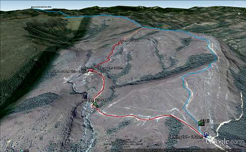
From Aiuruoca, find a taxi that can drive you up to "Do Lado de Lá" Hut. That can cost you easily R$ 100,00 (around USD 40.00), about 40 minutes drive and it takes you from the city at 1.000m high to the parking lot marked on the images already above the 1.800m line.
Folow the marked trail over the images and you won't have any problem. The path used to be a road back in the day, very popular with 4x4 meetings, and people used to drive all the way up to 2.145m high, at Refugio dos Pedros, a small camp made with a circle of rocks 2 feet high, done in the 18th century! So History can be seen in here too. Respect the place, take your photo, but don't change anything please, leave for the summit now just 20 minutes away.
Red Tape
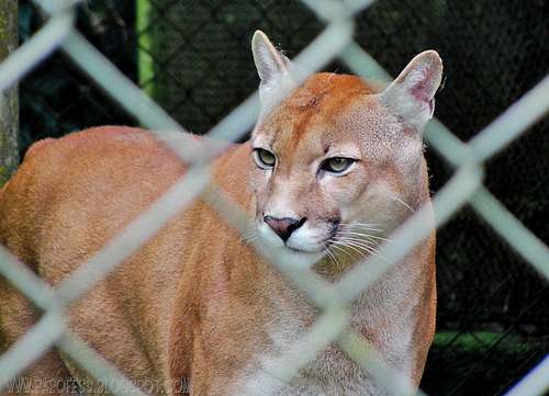
Photo in São Paulo Zoo, for illustration of this beautiful cat.
As said above, be very careful with wildlife in here, protect yourself, DON’T MAKE FIRE to drive away the animals, don’t leave food leftovers inside the tent, close a double bag with it and leave outside the tent, at least 30 feet away, and take it with you next morning. Most likely no wildlife will approach, but if this happens, you’ll be safe. To drive wild animals away some noise will do just fine.
There’s quite a few reports of the feared Onça Pintada (Panthera onca) attacks, the last one a couple years ago, it killed ayoung girl outside the city by the road, and police found only the girl’s head, sad story. Be careful also with the Suçuarana, this animal will probably run away from you, but if it’s a female and a recent mother, that could be a problem. The photo was taken in the São Paulo Zoo, gorgeous cat indeed. Also, be alert for poisonous snakes and bugs.
To pass time, work on long exposure shots! This section of Mantiqueira is good for it, lots of stars


Weather Forecast

Click over the image to jump to the weather forecast page
Legal Issues
To hike/ climb is a dangerous activity and requires proper equipment and clothing, the owner of this page cannot be blamed by injuries caused to anyone who read this page for its info about the mountain, and eventually got hurt by doing so with reckless behaviour or bad weather conditions.
Paulo Roberto Felipe Schmidt – AKA: PAROFES
External Links
My youtube channel: www.youtube.com/parofes - Now with 270+ videos online!The biggest brazilian website about climbing and mountaineering, for which I'm a columnist: