
-
 38624 Hits
-
 87.4% Score
-
 25 Votes
|
|
Mountain/Rock |
|---|---|
|
|
41.99592°S / 173.66287°E |
|
|
Download GPX » View Route on Map |
|
|
9465 ft / 2885 m |
|
|
Overview
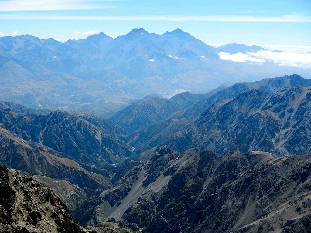 Inland Kaikoura and Clarence River valley viewed from Manakau
Tapuae-O-Uenuku is the highest peak in the Kaikoura Range, and also the highest peak in New Zealand outside of the Southern Alps. It is a fine alpine mountain, offering stunning views on a clear day. It holds historic significance for the country and is one of only ten NZ ultra prominence peaks (over 1500 meters of prominence).
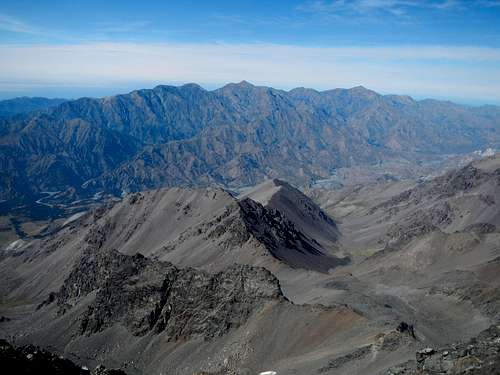 Seaward Kaikoura and Clarence River valley viewed from Tapuae-o-Uenuku
The Kaikoura Range actually comprises two parallel ranges close together and separated by the remote and difficult to access Clarence River. Tapuae-o-Uenuku is the high point of the Inland Kaikoura while Manakau is the highest of the Seaward Kaikoura. For a range that reaches above 9000 feet, it's unusual that there is no geologic sign of any previous glaciation.
 With Snow With Snow |
 Without Snow Without Snow |
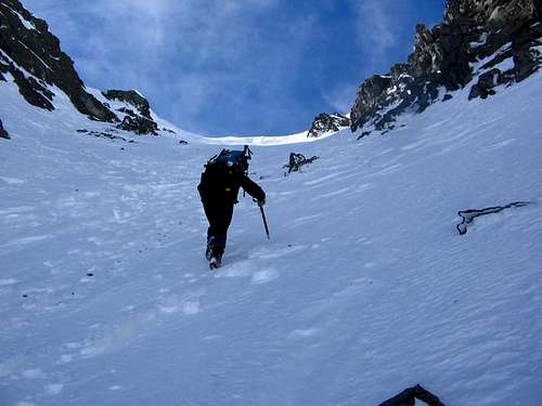
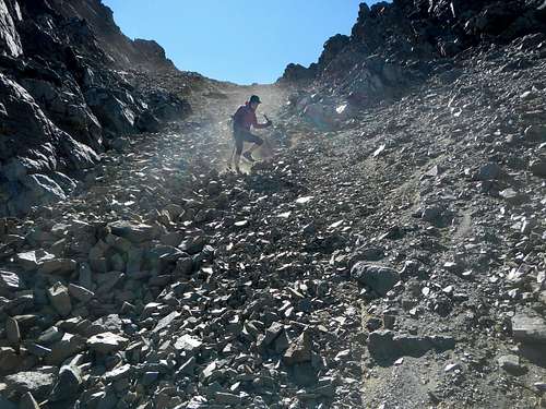
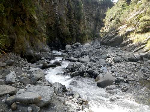
The main route is non-technical but does ascend steep snow or scree slopes near the top, so the experience of using crampons and an ice axe is necessary unless you go in late summer. The most extraordinary thing about the standard route is that it requires fording the Hodder River between 50 and 80 times.
![Hodder Gorge]() Hodder River Gorge
Tapuae-O-Uenuku is generally climbed in 3 days, however, some faster parties are able do it in 2 days. Camping out is not necessary because there are two good-sized huts that are maintained by the DOC.
Hodder River Gorge
Tapuae-O-Uenuku is generally climbed in 3 days, however, some faster parties are able do it in 2 days. Camping out is not necessary because there are two good-sized huts that are maintained by the DOC.
![The North Ridge]() The North Ridge
The first attempt on Tapuae-o-Uenuku took place in 1849 led by Edward John Eyre the Lieutenant Governor of New Zealand. He was accompanied by seven Maoris. They fell short of the summit and on the return trip Wiremu Hoeta slipped on ice and fell to his death. This was the first European alpine climb in New Zealand and also the first recorded alpine fatality. The first successful ascent took place in 1864, a party of 3 led by local farmer Nehemiah McRae.
The North Ridge
The first attempt on Tapuae-o-Uenuku took place in 1849 led by Edward John Eyre the Lieutenant Governor of New Zealand. He was accompanied by seven Maoris. They fell short of the summit and on the return trip Wiremu Hoeta slipped on ice and fell to his death. This was the first European alpine climb in New Zealand and also the first recorded alpine fatality. The first successful ascent took place in 1864, a party of 3 led by local farmer Nehemiah McRae.
![Sir Edmund Hillary]() Sir Edmund Hillary
In 1944 Edmund Hillary was station in Delta Camp for RNZAF training. He was preoccupied with the snowy summit he could see from camp. At 5am one weekend he set off from Shin Hut, "A strong, cold wind had sprung up and I worked my way very slowly up to the Pinnacle at 8,800 feet....I was in a spectacular position. To the west above heavy clouds towered a range of snow capped peaks....To the east was the blueness of the sea stretching all the way to Wellington." When he returned to camp, he was tired, dirty and disheveled but happy: "I'd climbed a decent mountain at last."
Sir Edmund Hillary
In 1944 Edmund Hillary was station in Delta Camp for RNZAF training. He was preoccupied with the snowy summit he could see from camp. At 5am one weekend he set off from Shin Hut, "A strong, cold wind had sprung up and I worked my way very slowly up to the Pinnacle at 8,800 feet....I was in a spectacular position. To the west above heavy clouds towered a range of snow capped peaks....To the east was the blueness of the sea stretching all the way to Wellington." When he returned to camp, he was tired, dirty and disheveled but happy: "I'd climbed a decent mountain at last."
![Along The Hodder]() Along The Hodder
The river bed is now followed for a few hours until you pass a minor fork. Take the right branch to stay on the Hodder River. The left branch follows the Shin River. Watch for the trail that leaves the river and climbs the east side of the gorge. This path climbs steeply and then traverses the slopes and later descends back into the river for a short period, before traversing the slopes on the west of the river and rising to the Hodder huts which are up on a terrace above the river. From the road to the huts takes about 6 hours, but can take far longer depending on the state of the river.
Along The Hodder
The river bed is now followed for a few hours until you pass a minor fork. Take the right branch to stay on the Hodder River. The left branch follows the Shin River. Watch for the trail that leaves the river and climbs the east side of the gorge. This path climbs steeply and then traverses the slopes and later descends back into the river for a short period, before traversing the slopes on the west of the river and rising to the Hodder huts which are up on a terrace above the river. From the road to the huts takes about 6 hours, but can take far longer depending on the state of the river.
![Summit Route Map]() Printable Summit Route Map
Depending on which way you go up, you will ascend one of the gullies above a basin or slope and pass through a saddle on the north ridge to reach the upper east face north of the summit. Alternatively you could follow access trails all the way to the Alarm/Tapuae saddle and then work your way north around a sub peak to reach the upper southwest ridge. Either way, this is potentially a long day. Hut to hut may take 10 hours.
Printable Summit Route Map
Depending on which way you go up, you will ascend one of the gullies above a basin or slope and pass through a saddle on the north ridge to reach the upper east face north of the summit. Alternatively you could follow access trails all the way to the Alarm/Tapuae saddle and then work your way north around a sub peak to reach the upper southwest ridge. Either way, this is potentially a long day. Hut to hut may take 10 hours.
 Hodder River Gorge
History
The name Tapuae-o-Uenuku translates to 'footsteps to the rainbow'. When Captain Cook sailed through Cook Straight for the first time on February 7th, 1770, he recorded the following in his diary, “Over this land appear'd a prodegious high mountain the summit of which was covered with snow.” He was staring at Tapuae-o-Uenuku and perhaps its close neighbor Mount Alarm. These two peaks are the highest in New Zealand outside the Southern Alps.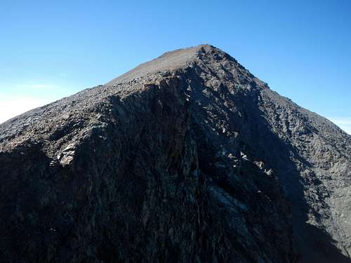 The North Ridge
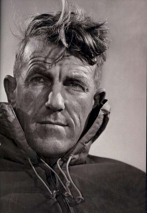 Sir Edmund Hillary
Standard Route - Hodder River
To gain the Hodder river, walk through the gate and up the track just opposite the Hay shed, past the farm buildings, through some gates, continue until you come to a large cairn on the track, about 45 minutes walk from the road. This is just after when you are opposite the tin hut down on the opposite bank. At the cairn descend steep slopes to the river bed.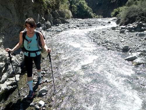 Along The Hodder
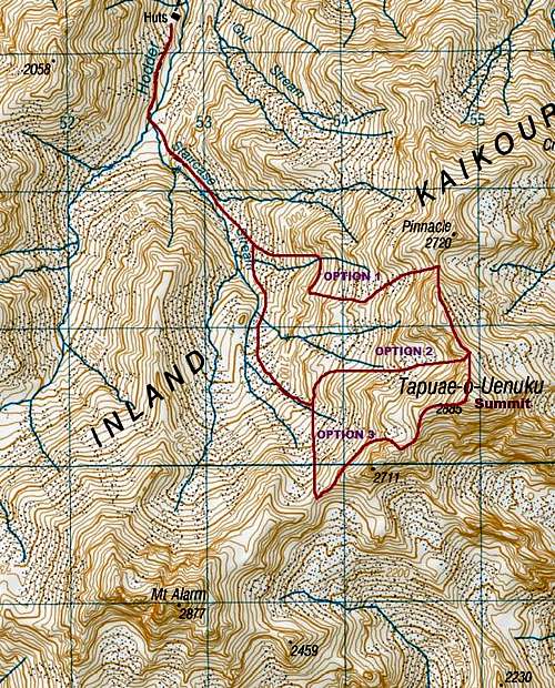 Printable Summit Route Map
Driving Directions
From Blenheim drive 20 km south on SH 1, about 4 km before Sneddon turn west and drive up the Awatere valley. From Christchurch up the SH 1, to the turn off 4 km past Sneddon. This road turns into a dust track, continue up this road for about 55 km until you come to a large Suspension bridge, the only one you cross, so easy to spot. Park in the bay between the bridge and the cattle stop. A sign on the gate requests that you ask at the nearby farm house for permission to cross the farming land between the car park and the Hodder River. Or you could try calling the number listed below.Red Tape / When To Climb
No permits are required, but to access the Hodder River private property is crossed. For permission to pass through call Alan and Bev Pitts 03 575 7471.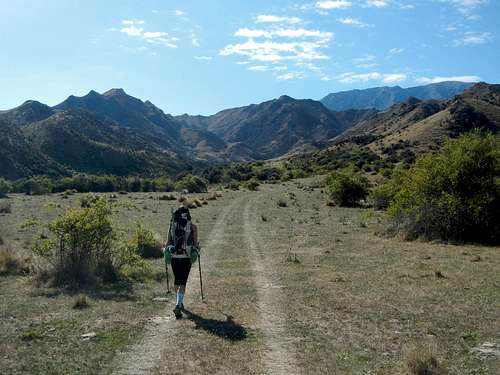 Farm Track
The main issue is access up the river, following periods of heavy rain the river may be impassable. This river has to be forded continually during the walk in.
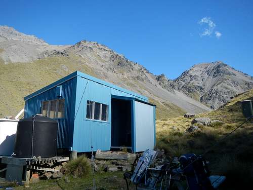
Camping / Mountain Conditions
Camping is allowed in the area, but good accommodation is provided at the Hodder huts. There are two huts (6 and 10 bunks), and two pit toilets. Both huts are in a good condition at the time of writing, containing running water, bunk beds with mattresses but no stove or fires. The cost to use the huts is $5 per night, per person.Contact the DOC for more information.
The DOC office at Kaikoura can also provide useful information on 03 319 5714.
 Hodder Hut
Alan and Bev Pitts 03 575 7471
For weather forecasts check the website of the New Zealand Met service.