Layout designed for best viewing on a "1024 x 768" screen.
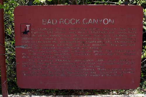
This faded sign along U. S. Highway # 2 in Northwest Montana reads:
The Bad Rock Canyon Sign
"The Flathead River enters the valley through Bad Rock Canyon. Old-timers aver that a Blackfeet war party from the plains surged over the divide years ago seething with ambition to corral a choice assortment of cayuses and maybe a scalp or two from the unsuspecting Flatheads, who claimed this part of the country for range and bed grounds. They came with stealth and breezed out with haste and horses.
"This foray put the home folks on the prod. They lined out on the trail of those vanishing intruders, determined to reclaim their mounts and their honor.
"The departing Blackfeet anticipated some such caper so, cunning and agile as squirrels, they took to a projecting rib on the canyon wall and laid for the irate oncomers.
"It developed into quite a disturbance. Many a warrior joined his fathers in the Great Beyond that day. Sorrowful relatives thereafter referred to that ill-omened citadel as Bad Rock."
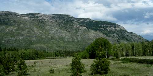
Teakettle Mountain is located on the north side of the “ill-omened citadel” Bad Rock that is mentioned in the above paragraphs and is part of the Whitefish Range. On the other side of Badrock Canyon lies Columbia Mountain, the northern most peak of the incredible Swan Range.
The Whitefish Range:
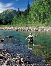
Fly fishing on the Flathead River
The Whitefish Range has dual-citizenship and calls both Montana and British Columbia home. Teakettle Mountain was the first of its peaks to be featured in SummitPost.
Teakettle Mountain is on the southern end of the incredible Whitefish Range and is located at the confluence where the South Fork of the Flathead River flows into the already joined Middle and North Forks to meander its way through the Flathead Valley down to Flathead Lake near Bigfork, Montana. The Flathead River is part of the Columbia River System and water from its peaks eventually empty into the Pacific Ocean near Portland, Oregon.
The Whitefish Range lies between Glacier National Park on the east and U.S. Highway #93 to the west. The southern boundary ends at the Flathead Valley near the Montana towns of Hungry Horse, Columbia Falls and Whitefish. The range extends to the north into British Columbia and ends just south of the Elk River corridor. This area covers over well over ¾ of a million acres and a proposed wilderness, the Winton Weydemeyer Wilderness, covering 171,000 roadless acres has been proposed in Montana.
Rails and Roads:
The Rail Line and Columbia Falls Aluminum Plant
This area also has a significant history to transcontinental travel as well. Today, as in years past, the main line of the BNSF railroad follows the north side of the Flathead River below Teakettle Mountain through Bad Rock Canyon after following the Middle Fork of the Flathead River from about 10 miles east of Essex, Montana.
On the south side of the river U. S. Highway #2 travels east and west below Columbia Mountain. It is via this highway that motorists access Glacier National Park as well as the northern areas of the Swan Range and Great Bear Wilderness.
Below is a brief history of the rail and the road.
The Great Northern Railway was constructed through Badrock Canyon in 1891. Prior to that, in 1890, the railroad contracted with Shepard Siems & Company to construct a road on the opposite side of the river to carry supplies to the railroad workers. The high canyon walls on the south side of the river were a major obstacle to the contractor, requiring extensive blasting to carve the road high above the canyon’s floor. When completed in 1891, the road was so steep in places that wagons had to be lowered down it by ropes tied to trees-thus it was called the "Tote Road" by the local residents. It was not until sometime between 1906 and 1914 that the county built a new highway through the canyon, bypassing the old tote road with a more user-friendly thoroughfare.
Pioneer Billy Berne owned a small homesite at the west entrance to the canyon. Berne and his brother Mike came to Columbia Falls from Butte in 1889. For years the brothers manufactured bricks, which were used to construct many buildings in the area. In 1929, the construction of U.S. Highway 2 destroyed much of the Berne homesite. In 1953, a niece of the Berne Brothers sold a tract of canyon land to the State of Montana for use as a roadside park dedicated to the memory of her uncles.
Source: Ultimate Montana.com
An Historic Fire:
In 1929, The Half Moon fire started on the west side of Columbia Falls and in just 3 days burned 103,000 acres as it cut a 30 mile wide path of destruction. Teakettle and Columbia Mountain were both burned. The fire followed the Flathead River to Apgar and destroyed the Apgar Lookout as well as burned the southern slopes of the Belton Hills just east of West Glacier, Montana.
The Glacier National Park Administrative web site has the following information on The Half Moon Fire.
“The year 1929 was dry and potentially dangerous for fire, but the park had been relatively lucky, with no fires of any consequence. Then, on August 16, a slash fire, burning on private logging operations between eight and ten miles outside the park boundary, near Columbia Falls, escaped from its bounds under high winds and low humidity conditions, and the famous Half Moon Fire of 1929 was underway. It overran the logging crews of the Half Moon Lumber Company and forest crews were sent to stop the fire.
Carrying as a crown fire across portions of the Flathead and Blackfeet National Forests, on August 21 it jumped the North Fork of the Flathead River into the park, near its southwestern corner. From there the fire spread rapidly eastward, on both sides of the Middle Fork of the Flathead River toward Belton and Lake McDonald. By some miracle of fate, it missed Park Headquarters, Belton and most of Apgar, but continued eastward almost to Nyack before being stopped.
All fire control agencies in the northwest were called in on this fire and personnel came from all over the United States. Fire Control Expert John Coffman, of the National Park Service, arrived on the 22nd and personally took charge of the park organization, but before it was over the park lost over 50,000 acres of fine forest, of which about 10,000 acres was a heavy stand of reproduction from previous burns. The entire fire burned, both inside and outside the park, approximately 103,000 acres at a total cost of over $300,000, $244,000 of which was expended by Glacier National Park. Those who drive along the road between West Glacier and the foot of Lake McDonald today do not see the devastation wrought by this fire, as the old burn is being rapidly replaced by a thriving crop of lodgepole pine, replacing the majestic stand of red cedars and hemlock that were there prior to 1929.”
Teakettle Mountain was thus named “Teakettle” after the 1929 Half Moon Fire due the way the fire burned the trees which left a formation resembling a tea kettle.
Columbia Falls Aluminum Plant:
A major employer in the Flathead during the 50’s until the early 2000’s was Columbia Falls Aluminum Plant (CFAC). CFAC sits on the western side of Teakettle.
Teakettle Mountain during the Flouride Emmission Problems
Gaseous and particulate fluoride emissions have been linked to the loss of trees as well as damaging wildlife on Teakettle’s western face. In years past these emissions also have impacted both animal and plant life in Glacier National Park as well. In 1985, Atlantic Richfield Company (ARCO), the former owners of CFAC, began taking steps to correct this problem and trees can once again be seen on the mountain above the plant. The plant has been working cooperatively with Glacier National Park to solve this problem.
Here is a brief history of the Columbia Falls Aluminum Plant:
Hungry Horse Dam (near Hungry Horse, Montana), the first major federal dam built after World War II, was completed in 1953.
The project employed many ex-servicemen with young families, and an industry was needed to retain the work force in the Flathead economy. The Harvey Machine Company first acquired options for an aluminum plant in the Flathead in 1949, and shortly after purchased 1000 acres six miles north of Kalispell at Rose Crossing. Although Harvey was unable to obtain financing to build the plant, on November 6, 1951, Anaconda Copper Mining Company acquired 95 percent of Harvey's interests, and on August 30, 1952, Anaconda announced that it would build its $45,000,000 aluminum reduction plant two miles northeast of Columbia Falls near Teakettle Mountain.
Two years and eleven months later, the first aluminum was produced on August 12, 1955. Initial construction consisted of two potlines with an annual capacity of 67,500 ton. Ten years later, in 1965, the third potline was added. With the addition of the fourth potline on August 3, 1968, and the fifth line in October of 1968, capacity was increased to 180,000 ton per year.
In 1976, Anaconda purchased Sumitomo process technology to improve plant safety, industrial hygiene, production efficiency and energy conservation. This technology allowed the plant to reduce carbon/chemical consumption and plant emissions. The Sumitomo conversion cost was $42,000,000.
The Anaconda Company was purchased by Atlantic Richfield Company (ARCO) on January 12, 1977. ARCO continued to implement and complete the Sumitomo technology improvement. In December of 1983, ARCO announced intentions to divest its Metals Division (brass and aluminum operations) including the Columbia Falls plant. In September of 1985, ARCO announced that the plant had been sold to the Montana Aluminum Investors Corporation, which would operate it as the Columbia Falls Aluminum Company.
On May 28, 1999, CFAC was purchased by Glencore AG. Glencore is headquartered in Baar, Switzerland and is engaged internationally in the processing and trading of metals and minerals, energy products, and agricultural products. Glencore is a leading world trader of aluminum and major supplier of smelter grade alumina ore.
Source: CFAC History
Due to a limited supply of materials as well as the cost of power CFAC is no longer a player in the aluminum industry. Most aluminum is now produced overseas. CFAC had to have the ore brought in via train and also had to purchase power for smelting. Overseas plants are able to do it cheaper therefore CFAC and its employees are out of commission. Perhaps a time will come when they can once again compete for their share of the aluminum nugget.
Getting There:
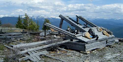
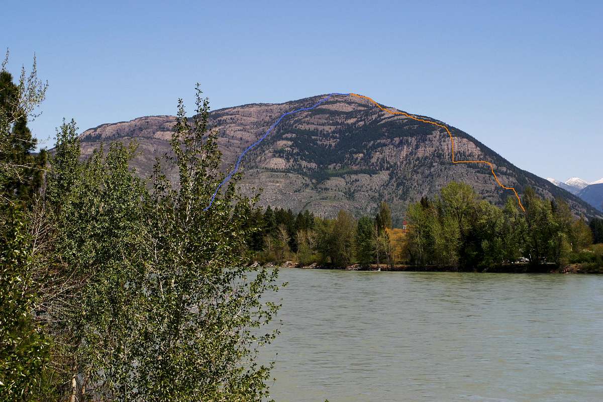
Teakettle Mountain's Summit
Teakettle Mountain stands at 5,936 feet and a 2,800 foot climb from Bad Rock Canyon is necessary to stand on the summit. Access is somewhat difficult due either having to negotiate around private land, cross the Flathead River by boat or a longer climb from the northwest side of the mountain which can be access from The North Fork Road out of Columbia Falls, Montana.
It is not difficult to get to Kalispell, Montana. It is located about 30 miles west of Glacier National Park. It is also about 5 hours south of Calgary, Alberta and 5 hours east of Spokane, WA. It is also about 2 hours north of U.S. Interstate 90.
The Flathead Valley is served by air, passenger trains, and bus service. U.S. Highways 2 and 93 intersect the valley and Montana State Highway 83 which travels along the Swan corridor from near Seelye Lake, Montana to Bigfork, Montana.
Teakettle Mountain is between Columbia Falls and Hungry Horse, Montana and is just across the river from the Berne Memorial Park in the Bad Rock Canyon.
Red Tape and Other Information:
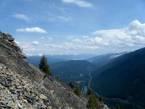
The South Fork of the Flathead River from Teakettle Mountain
Red Tape:
There is little red tape for this climb. Be careful to respect the private lands surrounding the base of Teakettle as well as the BNSF right of way and the Columbia Falls Aluminum Plant property.
When to Climb:
It would be possible to climb this mountain at any time of the year. Cold water and high water might deter a southwest slope route.
Camping:
There are numerous USFS campgrounds in the Flathead National Forest. See Local Campgrounds for more information.
Essential Gear:
After leaving the river this is a dry route so bring water and the other necessary equipment for climbing.
Route Information:
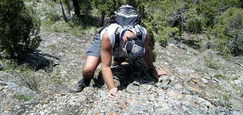
Challenging Cliffs on the SW Slope Route
There are at least three know routes to the summit of Teakettle Mountain.
The East Side Route:
Why walk when you can ride or drive? In the past that is how some folks thought. During the hang gliding days folks would drive up and launch off of Teakettle for a sweet ride on the air currents. The current hiking trail begins near Blakenship Bridge and meanders its way through the Flathead National Forest to the top of Teakettle. This trail is marginal at best according to a friend who drove his 4 wheeler up there about 8 years ago. Access may be restricted now so check with the U.S. Forest Service before using this approach.
This route looks boring…and lots of trees potentially block the views. Look at the USFS Hungry Horse Quad Map for location of the route and trailhead.
Northwest Slope Route:
This is a true western route! Where else but in the west would you find a climbing route that starts at a shooting range?
This route begins just off of The North Fork road at the North Fork Gun Club. At the Gun Club skirt along the lower slopes of Teakettle until reaching a climbable gully. Begin climbing up the brush chocked, talus slopes after reaching the slopes of Teakettle just southeast of the shooting range. It follows the north ridge to the summit after climbing the northwest corner of the mountain.
Southwest Slope Slope
Southwest Slope Route:
The most difficult part of this route is reaching the base of the mountain itself. The most common approach is to cross the Flathead River in a boat from the U.S. Highway #2 bridge on the South Fork of the Flathead on the west side of Hungry Horse. After reaching the other side locate an appropriate place to tie/hide the boat and climb up to the lowest portions of Teakettle southwest side. Climbing this side of Teakettle is difficult due to the loose rock, cliffs but the views are of the Flathead River, the Bad Rock Canyon as well as the Flathead Valley are enjoyable. Route finding is not difficult (just go straight up) and there are some nice (interesting) scrambles if desired.
After returning to the river the quickest access to the valley is gained by using the take-out at the House of Mystery Boat launch on the south side. The take out is approximately 3/4 of a mile below Bad Rock Canyon. Hopefully you have left a second vehicle here to drive back to the South Fork Bridge near Hungry Horse.
It is also possible to float the river to Columbia Falls to the Highway 2 Bridge where there is a take out on the north side of the river. This bridge is the first one below Bad Rock Canyon. There is pretty good fishing along this section if desired.
Total trip mileage was about 2,800 feet elevation gained due to the numerous false summits and unseen depressions below each false summit. Total trip distance on this route is approximately 6 miles.
It is not recommended that a descent is made down the southwest slope route. There are some pretty nasty cliffs to descend down. Instead look at the route topo and route photo to see suggested approach and descent routes.
Differing Views from Teakettle
Weather:
Local Recommendations for Eats and Treats:
If you have time for a quick treat after the climb stop by Willows Huckleberry Land for a Huckleberry Milk Shake. Willows Huckleberry Land is open between May and October. They have an assortment of jams and jellies in addition to their famous fresh huckleberry ice cream and milk shakes, fresh cherries and huckleberries (in season). The store is located on the west end of Hungry Horse on the north side of the highway. Their 8 foot tall mascot, "Huckey Bear" can be seen waving from their sign to visitors driving through Hungry Horse, MT.
Another must stop is for dinner at The Backroom in Columbia Falls. Be prepared to wait in line but the wait is worth your time. The hickory smoked spare, country or baby back pork ribs are prepared fresh daily with their secret spice blend, a flavor for which the Back Room is renowned! The baby red potatoes and fry bread with honey butter only enhance the dining experience. The Back Room also features succulent broasted or rotisserie chicken as well as pizza. They have a variety of wines, domestic, specialty beers, or liquor to compliment the dining experience. The Back Room is open Monday - Saturday from 4:00 p.m. to close and Sunday 2:00 p.m. to close. The Backroom is located in Columbia Falls behind the Night Owl Café across Highway #2 from the Town Pump and next to Freedom Bank. Start looking for the restaurant after the second stoplight in Columbia Falls when traveling west from Glacier National Park or Bad Rock Canyon.
Teakettle viewed from near Columbia Falls.
Guidebook:
The Climbers Guide To Montana by Pat Caffrey features Teakettle Mountain on page 54. This out of print book is difficult to find. The are a few copies available on line. It was published in 1986 by Mountain Press Publishing Company from Missoula, Montana.
Caffrey suggested: "East approach. Radio facilities on top. West side defoliated by air pollution from the aluminum plant at its base, which since has cleaned up its emmissions."
Children refers to the set of objects that logically fall under a given object. For example, the
Aconcagua mountain page is a child of the 'Aconcagua Group' and the 'Seven Summits.' The
Aconcagua mountain itself has many routes, photos, and trip reports as children.
Parents refers to a larger category under which an object falls. For example, theAconcagua mountain page has the 'Aconcagua Group' and the 'Seven Summits' asparents and is a parent itself to many routes, photos, and Trip Reports.

 27789 Hits
 84.27% Score
 18 Votes


