
|
|
Route |
|---|---|
|
|
47.51390°N / 121.7075°W |
|
|
Hiking, Mountaineering, Scrambling |
|
|
Spring, Winter |
|
|
Most of a day |
|
|
Overview
Have you ever wanted to summit two peaks in one day during wintertime, with a climb of only moderate difficulty, but not willing travel far from urban areas to do it? If you are in or near western Washington, then the "Teneriffe-Dixie Loop" route might be just what you are seeking. The route has steep slopes, gentle slopes, ridge crossings, spectacular viewpoints, and some YDS Class 2 scrambling.Route Description
 Southwest Ridge Trail
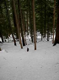
The route begins at the "School Bus Turnaround" (920' elevation) down the road from the Mount Si Parking Lot. Hike along the Mount Teneriffe Road-Trail for approximately 1.3 miles, until an intersection with a trail (which may or may not have a "This Is Not A Trail" sign) on the rightside of the road next to a small stream crossing (~1240' elevation). This marks the beginning of the Southwest Ridge trail for Mount Teneriffe. The trail is very rough, and has 1200' elevation gain during only the first 0.4 miles! Kamikaze Falls appears near 2300'-2500' elevation, and the trail steeply steers to the right of the waterfall area. Overall, the Southwest Ridge portion of this route has approximately 3500' elevation gain in 1.5-2.0 miles, and this section of the route is definitely the most difficult.
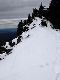
 Final Slope Of Mount Teneriffe
Be very careful on this section of the route. One miscalculation of a step or one piece of debris heading downhill might cause a hiker to slide uncontrollably down the steep ridge slopes. Be exceptionally cautious traversing this section of the route during wet conditions. A short time (approximately 15 minutes) after Kamikaze Falls, the route reaches a steep ridgeline and offers a rocky viewpoint. Continue steeply following the route up the ridgeline to the summit of Mount Teneriffe (4788' elevation). The Teneriffe summit is known for its spectacular views, and on a clear day will not disappoint.
 Heading West From Saddle Ridge
From the Teneriffe summit, descend the upper slope and begin following the Mount Teneriffe Trail, heading west. The trail traverses through a forest, going downhill and then heading up an unnamed highpoint, eventually reaching the upper end of the Mount Teneriffe Road-Trail (4280' elevation). Follow the road-trail downhill until it reaches a saddle ridge (4150' elevation, LATITUDE: 47.5139, LONGITUDE: -121.7075) where the road-trail sharply turns south from the ridge. From the saddle ridge, leave the road-trail and continue heading west along the steep forested ridgeline to an unnamed highpoint (~4450' elevation).
 Ascending Dixie Peak Ridgeline
From that unnamed highpoint, the ridge turns north towards Dixie Peak. Follow the ridge down and then up to the true summit of Dixie Peak (4606' elevation). Use caution when traversing the Dixie Peak ridgeline; steep slopes and high winds are common in this area. While approaching the true summit, try to looking for Crater Lake down the gully to the west. The views from the true summit are wonderful and very underrated. From the true summit, a hiker can continue following the ridgeline north for approximately 5-10 minutes to the false summit of Dixie Peak. The false summit is worth visiting, due to its rocky highpoint and spectacular views that rival the views seen from the Mount Teneriffe summit.
 Descending Steep Forested Slope
From Dixie Peak, head back south along the ridgeline to the unnamed forested highpoint. From this location, there are two main choices:
1) Retrace your route back to the saddle ridge to rejoin the Mount Teneriffe Road-Trail, or,
2) Cut-off approximately one mile of descent distance by directly traversing down the steep southern/southeastern slope of the highpoint through a forest, eventually rejoining the Mount Teneriffe Road-Trail at ~3950' elevation.
Then continue following the Mount Teneriffe Road-Trail for the remainder of the descent, returning to the "School Bus Turnaround" and completely the two-peak loop.
The "Teneriffe-Dixie Loop" route is approximately 12-13 miles total. It is HIGHLY recommended to travel this route in the manner which is described here, as going the opposite direction would involve ending the route with a steep and unstable (i.e. potentially dangerous) traverse down the Southwest Ridge of Mount Teneriffe.
Getting There
DIRECTIONS FROM I-90: Get off on Exit 32. Go north one mile where you will pick up North Bend Way. Make a left (west) towards North Bend on North Bend Way. After driving about a quarter mile take a right on Mount Si Road. Follow Mount Si Road approximately 1-1/4 miles past the Mount Si trailhead/parking lot to the "School Bus Turnaround" area. On your left is blocked fire road. Park here but make sure not to block the entrance to the fire road. Do not park here during school days unless after 5:00 PM.Essential Gear
Hiking/mountaineering boots, trekking poles. During snowy winter ascents, it might be helpful to have snowshoes, 'Yaktrax', and/or crampons during different sections of this route.Red Tape
Beginning during 2010, the Kamizake Falls Trail was greatly shortened and no longer officially connects to the Mount Teneriffe summit. However, using a map and/or GPS as a reference tool, the route can be retraced as a backcountry trip. Remnants of the old connector route between Kamikaze Falls and the Mount Teneriffe summit can still be found in certain areas.Because of this change to the Kamikaze Falls Trail, it is highly recommended to follow the route explained on this page via the road system only and not the old trail system. This will help forest regrowth along the old connector route.
Beginning during 2011, parking areas and trailheads within and for the Capitol State Forest require a Discover Pass to be in each vehicle during the visit. Failure to have a Discover Pass visible within a parked vehicle at these locations can result in a substantial fine. For more information regarding the Discover Pass, please visit the official website.