
|
|
Route |
|---|---|
|
|
47.50900°N / 121.695°W |
|
|
Forest scramble |
|
|
Half a day |
|
|
Class 2 mostly but with a little Class 3 |
|
|
Approach
This climb starts from the school bus turnaround mentioned in the Getting There section on the Main Page. Elevation 920 ft. A gated logging road leaves in a NW direction from the turnaround. If you pass a water tank on the right shortly after the gate, you are on the right track.
Walk the road for one mile to an obvious junction at 1,180 ft. Go left at the junction and continue for another third of a mile as the road bends a few times. Look closely for a trail leaving the road at a small stream. The trail starts on the downhill side of the stream but shortly crosses it. There may be flagging. This is the "trail" for the Southwest Ridge Route. This is an unofficial trail but still way faster than going via the logging road route.
Elevation gain = 3,900 ft. Time = 3-4 hours up depending on your fitness level. A really strong climber may be able to knock this out in 2 hours.
 |
Route Description
The trail winds up the stream for a while then sort of leaves it for a while until arriving at Kamikaze Falls closely to its right. A short side-trail diversion goes to the base of the falls. The falls plummet in the area of 2,300 to 2,500 ft. The trail then climbs steeply right of the waterfall to finally reach the crest of the ridge at about 2,800-3,000 ft.
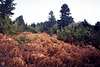
Follow the ridge wherever the trail goes pretty much all the way to the top. The first part of the crest is rocky in places but manageable. The rocks are mossy, so you need to be careful in wet weather. Higher up the trail is through open underforest before finally arriving at the base of a fern slope.
The fern slope is broken up by a rock outcrop. This would be the crux of the climb. Veer left at the outcrop. A short Class 3 scramble through this largely vegetated rock outcrop gets you above it. More fern and/or forest is encountered until just before the summit. The climb can be finished in trees or on the summit rocks to the right. Neither is very difficult. Conditions would dictate which finish you undertake. The rocky finish could be icy in late season.
Return the same way.
 |  |  |
Essential Gear
Foul weather gear, if necessary.
Ice axe in late season.
The climb is probably too steep for snowshoes in winter/early spring.
80% of the climb is in forest.
 |
Miscellaneous Info
If you have information about this route that doesn't pertain to any of the other sections, please add it here.