Five years ago...
2012, the Soccer European championship is just about to start. All eyes are riveted towards Ukraine and Poland. Despite the first of the two is the main organizer, Poland seems to focus most of the attention in medias, being a part of the European Union and Schengen.
Poland is promoting herself, since a significant part of the supporters are likely to take the opportunity to visit a bit the rest of the country... Mountain lovers will logically converge to the highest mountains of Poland, but those who do not have this chance will perhaps only be curious to find out more about them.
This trip took place five years ago, exactly at the same moment of the year, but it is still very up to date. The story, as I wrote it at this moment, go a bit beyond the postcard-like descriptions of guidebooks about Poland, breaks deliberately some stereotypes, but also enhance the true beauty of the Polish Tatras, giving tips about better ways to enjoy them as they should.
The text is a bit long, but I hope you will enjoy the read !
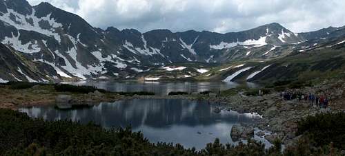
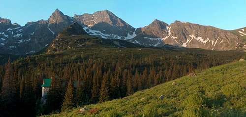
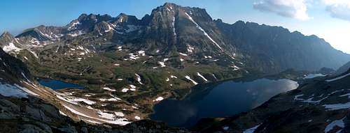
![The Polish High Tatras seen from the heights somewhere on the north west of Zakopane]() The Polish High Tatras seen from the heights somewhere on the north east of Zakopane
The Polish High Tatras seen from the heights somewhere on the north east of ZakopaneThe Polish Job
Considering that the mountain surface in a country should be proportional to its population, so that they can be entertained homogeneously, Poland suffers a great injustice, when compared to Slovakia, especially if we stick to the Tatras. Only one fifth of the latter is located in that country. Talking about the population statistics, it is rather the opposite!
Even talking about the "Polish side" is an euphemism because of both sides of the massif, a large number of valleys flowing on the North slopes are located in Slovak territory. Geographical injustice, dating back to the depths of history. Amongst the four major regions circumventing the Tatras foothills: Spiš, Liptov, Orava, and Podhale, only the last belong to Polish territory.
Fortunately, the Iron Curtain felt a long time ago, and it is now possible, once for good, to go hiking wherever we want. But habits do not disappear so fast, and the attendance of Tatras is still experiencing a huge imbalance between the two countries. Far from diminishing, the contrast on the contrary continues to rise, with the rapid flowering of outdoor leisures, increasing purchasing power, this coupled with the fact that many Poles who live far and rarely go to mountains tend to pick their destination to the "word of mouth", whose effect is getting them all the same places. We could compare this phenomenon to "Chamonix" in the Alps, or "Gavarnie" in the Pyrenees...
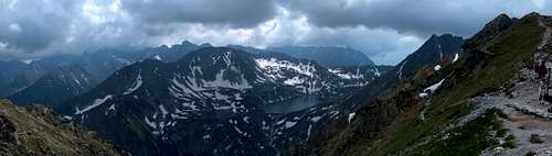
![The Polish High Tatras seen from the heights somewhere on the north west of Zakopane]() The Polish High Tatras seen from the heights somewhere on the north east of Zakopane
The Polish High Tatras seen from the heights somewhere on the north east of Zakopane
This brings us to the introduction of this trip report: constantly postponing my first true exploration of Polish High Tatras in a quiet season, either spring or late fall, I did do not have set foot in them. Kind of paradox since it is precisely in Poland that I live....
Poland is a very religious country, and the spring schedule is fantastic for Poles, throughout the period of May and June, with all its bank holidays and long weekends. Although we do not have the Pentecost Monday, we do have the "Corpus Christi", usually in early June, precisely this month. After already having May 1st and May 3rd, which we had allowed us 9 free days by taking only 3 days off. We had planned a new expedition into Slovak territory and the Low Tatras during four days. Unfortunately, my girlfriend (now wife) had to give up at the last moment: too much work... Change in the plans !
Well, here we are: since my crampons and ice ax are there since last Christmas and haven't been traveling much, and it is still late spring in the mountains, the moment is better than ever. Dorota already knows these places but not me, and given the fact she isn't too keen in difficult expeditions, for me it was now or never.
It had rained the entire week earlier, and nothing showed an improvement. However, the weather forecast website could not have been clearer: improvement during the weekend, with the best two days Friday and Saturday. I then decided to set the start on Thursday morning.
![The Polish High Tatras seen from the surroundings of Bukowina Tatrzanska]() The Polish High Tatras seen from the surroundings of Bukowina Tatrzanska
The Polish High Tatras seen from the surroundings of Bukowina TatrzanskaThe Krzyżne storm and a providential shelter
A bad dream suddenly pulled me out from my torpor, and I looked at the time: 4:30 am. The day already lit the whole room, which is not very surprising in Poland at a date close to the summer solstice. I went down quietly, swallowed my breakfast, and 20 minutes later, I was already speeding on the Highway, blinded by the rising sun.
Like usual, the fields of Lower Silesia gave place to the large pine forests of the Opole region, then the repulsive industrial landscapes of the mining region of Katowice, and then still further the bucolic hills near Krakow. The sky was still clear, when I left the A4 in the direction of the Zakopianka, the road leading south to the mountains. But I noticed a small cumulus, atop a hill, that seemed to mocks me, saying "hurry up !".
Once I passed Nowy Targ, over the barrier of the Tatras, I noticed with a slight concern a beautiful crown of white clouds, although still sparse, over the highest peaks, at 9am already.
The counterpart of this anxiety was to have succeeded to precede the religious processions on the roads, especially in the last small villages, where lots of people converged to all churches in their best suits, on this holy day. I finally parked at 9:30 am at the Łysa Polana car park, just before the Slovak border, already full of cars. It should be underlined that the car park is the trailhead of several valleys and sites frequented, including the famous Morskie Oko...
Having paid the parking guy, with the "more than one night" rate, with quite expensive price as it implies, ice ax and mat got eventually grafted onto my backpack, already quite round, and off I went. I had planned some sort of loop through the three main valleys that make all the fame of the Polish Tatras, anticlockwise, and the first stage was to rally the Murowaniec refuge, in the westernmost of the three Dolina Gąsienicowa. If the last two valleys converge towards where the car is parked, this one does not, and the goal is to switch to it by a pass at 2112m, Krzyżne.
In order to climb Krzyżne, we need to elevate first in the Dolina Pieciu Stawów, that for convenience I shall refer by its more popular translation: the "Valley of five lakes." This is the second valley, in which I am supposed to spend the second night after tomorrow. Good opportunity to see if it is possible to book a bed in the hut while passing by...
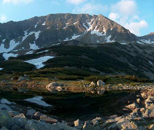
![Przedni Staw, the first of the serie in Tatra s 5 lakes Valley (Dolina Pięciu Stawów)]() Przedni Staw, the first of the serie in Tatra's 5 lakes Valley (Dolina Pięciu Stawów)
Przedni Staw, the first of the serie in Tatra's 5 lakes Valley (Dolina Pięciu Stawów)
At 10 am, I am walking the trail-highway, like an anonymous molecule in the flow of tourists. I soon reach the embranchment of the valley of five lakes, which I still walk up with wide strides. Here and there, tourists call mobile phones, take photo of themselves, girls put some make-up... On the path, floats a faint smell of perfume and deodorant, which I hate... I am looking forward to escape myself from this glue, what's more the itinerary isn't very rich in open views so far as the trail goes under the forest. Occasionally, we can see the the bank of the blue mountain brook, where unfortunately it is not uncommon to find some empty bag of chips stuck in the roots, or some crushed cans. As the end of the valley gets steeper, the trail leaves the vegetation to begin a series of laces. Sweating, I do not slow down, for two main reasons: I am feeling that I finally detach from the pack "late morning hikers", but above all, the white cumulus seen this morning have gotten kind of fatter, now spanning a little more gray, and leaving less and less rays of bright sun ...
At noon, I finally reach the hut, and I head to the reception : "Is there room for one person, for .... ". I do not even have time to finish my sentence. "NO! It's packed !". My turn to interrupt : "TOMORROW evening, please. ". The hut-keeper hesitates, then looks at his notebook quickly. "No, I'm sorry, there is really no room... it will probably required to sleep on the floor."
I expected it a bit indeed, and I don't lose more time, I'm siting before the first of the five lakes in order to eat few sandwiches. This broad valley looks attractive, but the partially cloudy weather of today is certainly not the best time to linger. I told myself I'll have plenty of time tomorrow in the late afternoon on the way down.
![Tatra s 5 lakes Valley (Dolina Pięciu Stawów) as seen from the trail to Krzyżne]() Tatra's 5 lakes Valley (Dolina Pięciu Stawów) as seen from the trail to Krzyżne
Tatra's 5 lakes Valley (Dolina Pięciu Stawów) as seen from the trail to Krzyżne
I must not lose any more time to Krzyżne, because the clouds have kept inflating during my sandwiches. What I was fearing seems to become more and more true... As soon as thinking that, I am back on this path that first heads north, overlooking the Valley of 5 Lakes. First, relatively flat, it passes a small lake before attacking suddenly a very steep climb. There are no less than 400 meters of vertical climb in one go, on a patch of half grassy half rocky mountain slope. Halfway up, I am taking a break, thanks to a large clearing. The view extends to the second of five lakes, the hut already seems microscopic, and below the mouth of the first lake, it is now possible to admire the beautiful waterfall over its entire height. I meet few tourists on the trail, now far away from the crowds.
Second half, and last stretch, and here I finally come to Krzyżne. A pass or a summit, you can call it by the two, it is a passage on a mountainside topped by an unnamed secondary summit, just above. On the other side, the trail descends much more gradually to a large glacial ravine filled with granite boulders.
![Tatra s 5 lakes Valley (Dolina Pięciu Stawów) as seen from the trail to Krzyżne]() Tatra's 5 lakes Valley (Dolina Pięciu Stawów) as seen from the trail to Krzyżne
Tatra's 5 lakes Valley (Dolina Pięciu Stawów) as seen from the trail to Krzyżne
This "mountainside" is actually the ridge the most famous Polish Tatras, called "Orla Perc", which literally means "eagles perch." It owes its fame to the marked trail that runs along its entire length, equipped with via-ferrata-like chains. Unfortunately, his fame is synonym with problems, including overcrowding during summer which generates "traffic-jams", and above all its fascination with neophytes, who visit it without knowing precisely their fitness level or climbing competences (call it "gymnastics" because it is not strictly climbing). Add it to people who suffer from vertigo... Few photos and a second break later, I hear a distant rumble. I turned around and noticed on the side of the highest peaks, on the Slovak side, that clouds had merged into a black sheet more menacing than ever, and running full speed. It's time to clear out ! As soon as i had packed my gear in hurry, I was hurtling down the Krzyżne north slope, Dolina Pańszczyca, which descends towards the Murowaniec hut.
Barely a hundred meters below the pass, I met a guy who walked up and interrupted me: "Jak na tom Orla"? (translation: "how does it look like on Orla Perc?", calling the route by its nickname, to look familiar. In my best polish, breathless, I explain him that there isn't much to do on Orla Perc at this time, apart from being struck by imminent lightnings. "Oh Really?" My interlocutor insists with further questions, but sorry, I have no more time to waste, and the most relevant answer I can offer is to brutally leave him continuing my descent at the same pace.
A little further down, still, I cross the amused smiles of two girls who walk in the opposite direction, seeming to think "this one is crazy or what...". Five minutes later I am still in the vast rocky corrie, but away from the ridges. BAOUM! The warning shot felt, followed closely by large warm raindrops. I continue my run for a few moments, without bothering to put on my rain jacket, too deep in my bag. I'm anyway already drenched in sweat!
![On Krzyżne (Polish Tatras), lookind down into Dolina Panszczyca]() Just before the storm on Krzyżne
Just before the storm on Krzyżne
I am immediately punished of this fatal negligence, when drops become a deluge. Other lightnings strike, closer and closer, and more and more often. I must do something, my situation is potentially dangerous. I finally find a place where few inclined rocks seem to form a shelter. Quickly, I throw my bag in a deep cavity between some rocks, and I crouched back against my so-called shelter. Actually mostly psychological: the rain falls in all directions, streaming down my spine, and the rock doesn't protect me at all from lightnings... After few minutes, I started to feel really cold, and felt a cramp in my legs. I looked at the sky and then around me, then noticed about twenty meters to my left, three girls stashed under another similar rock, but having had the presence of mind to put waterproof clothes on. Our eyes meet, and at the sight of my probably pathetic face, they let out a big laughter...
As the rain slowed down, a piece of blue sky miraculously opened over to where we stood, and we walked out of our respective dens. Questioning them: "You're probably also going to Murowaniec?" - "Uh, no, we're going up!" pointing fingers to Krzyżne, where clouds have not yet capitulated, and where, if I remember correctly, the last lightning had fallen. I'm stunned ...
Inventory of fixtures: some of my bread sandwiches are soaked in water, I can throw them. Fortunately, the camera was well isolated, despite a slight fog in the lens. The map is still folded in my pocket, better not touching it, it is as vulnerable as a Kleenex! As for myself, it is imperative to leave and not cooling any further. At the bottom of the Dolina Pańszczyca, vegetation reappears, and the trail passes a pretty little lake. A slight short climb follows, then we switch into the valley Gąsienicowa, which the latter is a tributary. The rest of the trail comes in sight: it plunges into a thick pine forest, where we already see the emerging roof of the Murowaniec hut.
![Traditional sherperds huts in Polish Tatra s Dolina Gąsienicowa]() After the storm...
After the storm...
Sun returns, creating striking contrasts with the still dark sky, near the border ridge. The trail follows some strange limestone hills, on the geological transition zone. The north side of the mountains range of Orla Perc is gradually revealed, as a large amphitheater of dark craggy peaks, in the center of which sits a strange pyramidal peak, like the needle of a sundial: the Kościelec peak.
Murowaniec, which proves to be a very nice and huge hut, faces this beautiful landscape. Without delay, I head to the reception to book a bed. The race left me sequels, knees hurt ... People are queuing: a first group of four, then a couple, without success, which puts me the red flag. "Are you alone? Wait, we check if there is a bed somewhere there". Unfortunately, without a better result. I'm invited to poke back after the 6pm time limit, beyond which the pseudo-bookings are usually considered like withdrawals.
What can I do? It is still 4am, so I go to take refuge in the refectory on the ground floor, crowded with steeped hikers, but getting emptier as the storm retreats in the evening. I finally have enough space to spread out my map to dry, and change my clothes. Then I offer myself a good "goulash" with hot potatoes, with a great beer.
Next to me, two Poles who look a little like hippies settle, with their bags crumbling with climbing equipment, ropes hanging out. As usual, my interlocutors are immediately intrigued by my accent, and fascinated by the fact of meeting a French in the Tatras, and we quickly get acquainted. "Did you get a space ? "I ask. "No, we sleep under the stars! Tomorrow we'll climb Kościelec by the steep side... if we don't get caught !". It should be pointed out that offtrails hiking is strictly regulated, and that access to climbing routes is subject to a very strict regulation, which requires amongst other things to be affiliated in a recognized climbing club...
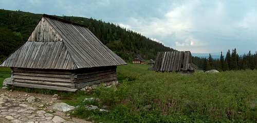
![Traditional sherperds huts in Polish Tatra s Dolina Gąsienicowa]() Traditional sherperds huts in Polish Tatra's Dolina Gąsienicowa
Traditional sherperds huts in Polish Tatra's Dolina Gąsienicowa
Around 5:30pm, rays reappear. It is still 18, so I decide to go outside for a walk in the adjacent meadow to the refuge, take some pictures, because there are some lovely pastoral mountain huts around, all in the traditional wooden style of the region.
In fact, it turns out that a number of them are more than pastoral shacks, because they are inhabited. One of them serves as a weather station, a second seems to be private, then after taking some pictures, I see a third, painted in dark red. People come and go, mostly hikers. As I approach by curiosity the entrance, I see a sign "Betlejemka hut." I gather my memories, because I have the feeling I read something on internet about this place, without remembering exactly.
An old man comes out, and in my best French-Polish, I ask if it is possible to sleep. The first answer is no, but he changed his mind and knocked on the window, where a woman washing dishes appeared. There's still a space left, and I very politely invited to stay. The man explains that this is an "unofficial" hut with a kind of ambiguous status, and is used primarily for mountain rescue teams, and occasionally members of Polish alpine clubs. Having just said I used to be a member of a French club, the man who turned out to be a climbing instructor, had graciously agreed to lend me the only bed inside a room under construction, for a modest sum of 25 zlotys.
![Schronisko <a href= http://www.pza.org.pl/szkolenie/index.acs?id=308004 >Betlejemka</a> in Dolina Gąsienicowa (Polish Tatras)]() Schronisko Betlejemka in Dolina Gąsienicowa (Polish Tatras)
Schronisko Betlejemka in Dolina Gąsienicowa (Polish Tatras)
The room "under construction" is actually more than comfortable, with a big table all for myself, and I finished to expand my wet gear for a fast dry at night. In this shelter, there is a gas stove, and even hot showers ! As I heat tea, a party of climbers arrive. They start preparing all kinds of food in industrial quantities, before starting to get a meal as well. Some of them speak an approximate French which result of some mountain courses in the Chamonix area. These are all mountain rescuers. They latter eventually invite me to go for a beer in the hall of Murowaniec refuge, 200m below, which serves as the "pub"... We discussed many topics, including my few experiences in the Tatras, and my experience of today, and I learn at the same time that lightnings are one of the most important causes of fatal accidents in mountains !
Beer helping, they also asked me if I'm good at climbing and offered me to join their tomorrow "training", on some sort of wall near Orla Perc, which I was forced to decline, my level of climbing being pale ... And it is pitifully that I ask them if there are still patches of snow on the opposite side of Orla Perc, where the via ferrata goes, one of my possible route the next day. "I don't see what do you talk about" said one of them, racking his head. "You mean the path for tourists? Of course it's OK !". At 10pm, all faces are looking tired including mine, and everyone returns to Betlejemka. Sleep does not take long to conquer to my brain, just after my legs...
![Dolina Gąsienicowa (Polish Tatras) by night. Made with long exposure.]() Dolina Gąsienicowa by night. Made with long exposure.
Dolina Gąsienicowa by night. Made with long exposure.Świnica and a night under the stars
When I open one eyes, rays of light slip through the window. I grab my phone: 4:59, just in time to switch off the alarm. I already missed the sunrise as I had promised myself, but during heating my breakfast, I took nice photos of the valley bathed by the dawn lights. Yesterday's weather was is away, the air is pure, crystalline dew drops hang on every blade of grass, and far away in the the plain behind Zakopane, a compact sea of clouds lies down, shriveled.
Rescuers aren't slow to appear too, and I soon find the table spread with cheese and bacon... Backpacks in preparation lie in every corner. As they wait for the latecomers, I am finally ready before them, and we greet each other.
![Schronisko <a href= http://www.pza.org.pl/szkolenie/index.acs?id=308004 >Betlejemka</a> in Dolina Gąsienicowa (Polish Tatras), in the sunrise]() Schronisko Betlejemka in Dolina Gąsienicowa, in the sunrise
Schronisko Betlejemka in Dolina Gąsienicowa, in the sunrise
There is no one, the whole valley is all mine ! In front of Murowaniec, where the lunch service is still far from having begun, only a few sleepy onlookers came sniffing the morning air. The largest lake in the valley, Czarny Staw Gąsienicowej ("Black Lake Gąsienicowa"), extends its black clothe, barely rippled by the breeze, still out of reach of the sun. Since it is still early, and the weather should remain stable throughout the day, I decided to add the ascent of Kościelec as an appetizer of the day, before the true goal, which consists in taking me back into the valley of the Five Lakes, through the top of Świnica, and a part of the Orla Perc ridge, following the indications of emergency workers last night.
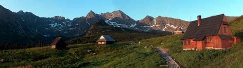
![Schronisko <a href= http://www.murowaniec.e-tatry.pl/ >Murowaniec</a> in Dolina Gąsienicowa (Polish Tatras), in the sunrise.]() Schronisko Murowaniec in Dolina Gąsienicowa, in the sunrise.
Schronisko Murowaniec in Dolina Gąsienicowa, in the sunrise.
Kościelec, is the small sharp peak that dominates the center of the amphitheater, whose name in Polish translates by means "little steeple". I have rarely seen a peak with such a geometric shape. It is a three-sided prism, shaped like a shark fin, whose narrowest face, inclined to 45°, is the one where a path leads to the top, narrowing gradually as it rises.
To access Kościelec we need to reach first with a small pass named "Karb", located on a ridge that separates the valley in two. I make a break as I reach it to breathe a bit. Then I hear voices, and I see a line downside made of a dozen of people: they are the rescuers from the Betlejemka hut, heading in the direction of the Zawrat pass for their training.
Apart from them, the stillness is absolute. I scan the horizon, and do not see any sign of presence of any other hiker. I can do what I was thinking about: leave here my "baby" (the backpack), and climb the remaining 300m of the Kościelec spade with only my camera. The inclined face of Kościelec is less "smooth" than it suggests from far, and the trail winds its way craftily to the top. We only need hands a couple of times till the end. It is just 7am, I am dominating the whole corrie of the Gąsienicowa valley on one side, and the fabulous Orla Perc wall on to the other.
![On Karb, looking to the Peak Kościelec. Behind on the right, the Peak Świnica]() On Karb, looking to the Peak Kościelec. Behind on the right, the Peak Świnica
On Karb, looking to the Peak Kościelec. Behind on the right, the Peak Świnica
Świnica, the main peak of the day, draws a terribly vertical north face. But this viewpoint serves me as I notice that the path leading to Świnicka Przełęcz (pass under Świnica), is not under snow patches, as I thought initially, but aside and clear. In addition, I won't need to walk down so much with the backpack, because I see a path that goes directly from the base of "Karb" to the start of the climb. I immediately adopt the idea, more exciting and "high mountain" that the initially planned route, and I'm back near my rucksack in a couple of minutes. Just before arriving at to him, the first hikers appear, a couple: "Oh gosh! And we believed we would be the first!".
The path I saw is ideal, it visits the lakes of the second wing of the Gąsienicowa valley. Behind a huge fallen rock bordering the lake, I notice two people sorting out some gear and fluorescent pink mats, duvets, and ropes. They are my two dining companions from the yesterday afternoon, who have indeed followed their plans, sleeping under the stars! As they recognize me after a first hello from the hand, they start screaming greetings...
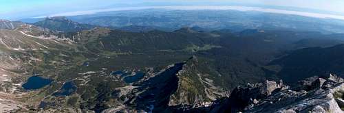
![Panoramic view to the valley Dolina Gąsienicowa from Karb]() Panoramic view to the valley Dolina Gąsienicowa from Karb
Panoramic view to the valley Dolina Gąsienicowa from Karb
I climb to Świnicka Przełęcz. After a gentle warm-up, the trail attacks a severe climb, in a chaos of granite boulders. Amongs the stones, I saw a sudden movement. A marmot. Then two. Then a third, who just hide. I walk on tiptoes, and after many attempts, I finally manage to picture then both.
I arrive on Świnicka Przełęcz in the same time than a group of other hikers on the trail coming from the crest. All simultaneously decide to put down the bags to drink, we spontaneously start talking about trail conditions and the via ferrata. People easily dressed up come from the opposite directions, so in theory there is little concern to have, but we chose to head all together in a group on the path that bypasses the summit Świnica, on the most exposed passages.
![Panoramic view to the valley Dolina Gąsienicowa from Kościelec]() Panoramic view to the valley Dolina Gąsienicowa from Kościelec
Panoramic view to the valley Dolina Gąsienicowa from Kościelec
Świnica is a proud 2300m summit straddling the Slovak border. The Southwest side offers views to the beautiful valley Ticha Dolina (peaceful valley), Tatras longest. The trail steepness increases few meters below the summit, then suddenly switch around it to provide the access via the other side, over the Five Lakes. Some passages are featured with chains, easy to deal with, for those who are subject to vertigo.
From the summit, we dominate the bowl-shaped end of the glacial valley of the Five Lakes, whose last one is still one half in the ice, the other of a glistening azure. We also dominate the beginning of the long ridge of Orla Perc, whose trail coming from the 5 Lakes is the very beginning, the pass we name Zawrat. On the rest of the border ridge, which softens for a while, other granitic peaks, all dark and all larger than each other, resurface in the distance, against the light.
Świnica is renowned for its summit views, and I have the opportunity to fully enjoy the best conditions. Moreover, the edge of Orla Perc, usually over-crowded during high season, is particularly quiet at this hour.
I make the descent with my trail fellows to Zawrat, large notch in the ridge that allows an easy passage between this valley and the one I left this morning. This portion requires some scrambling passages, always with a safety chain. My companions left and continued along the ridge, while I walked on the trail that descends into the valley.
I meet more and more people coming from the opposite direction, and most of them stop to ask if the ridge is far, if there is snow. Some are dressed and equipped for a place like here, some others less ... The last straw came when meeting a guy, no bag neither a bottle, who asked me, kind of scared : "Is it far? ". Embarrassed, I replied that everything depends from the destination he means. "Well, uh, I dunno. But this is far ?". I feel obliged to answer evasively ... "Yes, it shouldn't be so far..."
![From Zawrat, view to Zadni Staw, the last of the 5 lakes valley]() From Zawrat, view to Zadni Staw, the last of the 5 lakes valley
From Zawrat, view to Zadni Staw, the last of the 5 lakes valley
This is while chatting with some people (the French are meant to inform Poles in their own mountains!), that I met two female hikers, who noticed the English conversation. One is Dutch but the other from Wrocław. Indeed we saw each other before, as they slept also in Betlejemka. The one from Wrocław is a member of the Alpine Club, whose website I had read, but which so far I failed to join. Thanks to her I will eventually do it the week after !
We passed the half-frozen lake, then the four other in the valley, whose penultimate two are by far the largest. This large open valley is strongly reminiscent of places I have seen in the Pyrenees, in the Néouvielle or Aygues Tortes. My two teammates continue after the hut, with the rest of the valley to descend.
![From Zawrat, view to Czarny Staw and Wielki Staw in the 5 lakes valley]() From Zawrat, view to Czarny Staw and Wielki Staw in the 5 lakes valley
From Zawrat, view to Czarny Staw and Wielki Staw in the 5 lakes valley
As for me, I am a bit out of ideas: the very early awakening means also arriving very early at the destination, we are only at the beginning of the afternoon. I would hike more, but legs and shoulders are satiated after two peaks already.
I go to the hut reception in the slim hope of getting a bed, but with no illusions. In vain. The 5 Lakes hut is very pretty, but particularly small, and also very popular, too... In order to ask at the reception, I am obliged to wait all the queue, mainly made of folks waiting for meals and refreshing drinks. After ten painful minutes, I finally arrive at the counter, and I learn that the reception is located on the first floor !
Annoyed, I take the short opportunity, to offer myself a great beer, before heading backwards. Upstairs, a dozen people are waiting, sitting on the ground, vexed. A girl is having a nervous breakdown, "what the hell, what are they doing! still no one!". I drag my eyes around: people have already spread the sleeping mats in the corridors, in each small space... I'm giving up. I'll probably do like the two climbers from the day before, who slept in the wild.
![Wielki Staw, in the 5 lakes valley]() Wielki Staw, in the 5 lakes valley
Wielki Staw, in the 5 lakes valley
I'm moving a little farther on the lake shore, where the hikers frequency is less important. I brought a pocket-book in my bag (another usefulness that weights, with those damn crampons I have not used yet!). Now is the time to savor it, in a delicious smell of pines cones.
When I started reading, I was bathed in rays of sunlight reflecting from the lake surface. Hours later, the sun has gone down: I have already put on my trousers, my fleece and the softshell, still sitting on the same rock. I stop reading, taking a look at my watch. Already 7pm !
I returned to the shelter, where the evening meal start to be served. "A goulash with potatoes, please". "Okay, for goulash, here's the receipt, go to queue to the food service... "but, by the way the fact, you're only taking a goulash? Aren't you sleeping too ?". I skip skillfully the embarrassing question as the person behind me has already started ordering his meal, focusing her attention.
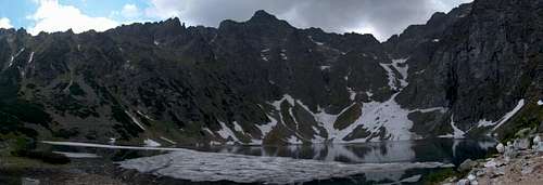
![The valley of the Five Lakes, from the shores of Mały Staw, Polish Tatras]() The valley of the Five Lakes, from the shores of Mały Staw
The valley of the Five Lakes, from the shores of Mały Staw
The Goulash is swallowed, I escape the refectory. The sun will soon disappear under mountain slopes, it is the moment I was looking for. I am heading to the 2nd lake in the valley, the largest, and sit back with my book. But it lasts few minutes, when I quickly grab the camera. The red rays are there as expected, and dye magnificently the mountains opposite. I took many panoramic shots, playing with the reflections on the lake, as flat as a glassy sea.
I observed in the same time the pass Szpiglasowa Przełęcz, on the opposite side, because this is the beginning of my journey the next day. Snow covers much of the rise. Crampons will finally be useful ! The darkness finally falls. Near the hut, between dwarf pines, I see a picnic area out of sight, where others had begun to install mats when I came out. I move to this place, where a lively conversation takes place between a cheerful dozen of hikers. It does not take long to ask me where I am from, and being French is obviously inspiring, raising many cheerful topics of conversation...
![Sunset on the shores of Wielki Staw, in the Valley of the Five Lakes, Polish Tatras]() Sunset on the shores of Wielki Staw, in the Valley of the Five Lakes
Sunset on the shores of Wielki Staw, in the Valley of the Five Lakes
Around 9:30pm, while darkness has totally felt, the hutkeeper suddenly burst, and yelled out loud a warning to the entire community: "Those who have not yet paid their night must do it now, from the moment camping is forbidden you must sleep in shelter!". Two or three others, apparently in the same illegal situation than mine, replied, offended : "And those who do not sleep INSIDE the shelter? ". "Yes, wherever out of the hut is a part of the National Park. And we do control it! ". Somewhat disappointed too, me and my companions to go pay, resigned.
In the Rycerzowa hut in the Polish Beskid, where my girlfriend and I slept last month, on the floor of the dining hall because it was full, we paid only one third of the normal price of a bed. This will probably be the same here, I thought. Error! Here, when sleeping outside (the refectory, as well as toilets, water heater room, hallways, reception, entrance hall, are fully packed), we must pay almost the full price ! "This is robbery!" Exclaimed my neighbor. The manager shrugs. "It's not my fault. It's like that."
You are now warned. If you plan to sleep to the Five Lakes, better do like the two climbers I had seen the day before, be careful not to get noticed, as we naively did...
I get back near the other guests who will also sleep under the stars, one is speaking french. We laugh at the mishap and chat briefly about mountains, before going to bed early, because everyone wants to get up early.
It is so far the only night under the stars that I spent in my life, and this one was particularly fresh. Wide variations in temperature are common in the Tatras in this the season, between night and day. I had taken a book and the crampons, but only a light sleeping bag instead of the warm mountain one. Big mistake !
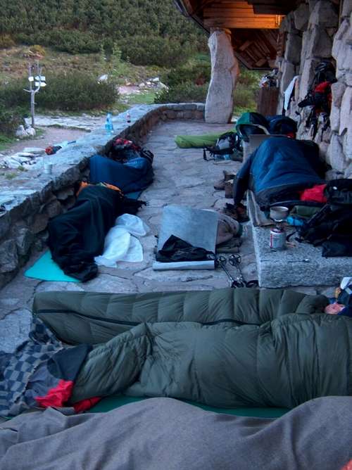
![Night in the <a href= http://www.piecstawow.pl/ >5 Lakes hut</a> during a busy week end.]() My night "in" the 5 Lakes hut ...
My night "in" the 5 Lakes hut ...Szpiglasowy Wierch, entering heaven from above
![Sunrise in the Valley of the Five Lakes, from the <a href= http://www.piecstawow.pl/ >hut</a>]() Sunrise in the Valley of the Five Lakes, from the hut
Sunrise in the Valley of the Five Lakes, from the hut
When I woke up, I had the polar, the waterproofs, pants, gloves and hat on, and I felt horribly cold in my feet. Sky was clear and blue but the sun not up yet. I looked at the watch: 4:30am. Too bad, I start. Everyone is still asleep around. I heat my tea (I have a gas stove, at least one good thing I brought). During the breakfast, I take some new photos of the lake, with salmon tones of the dawn reflecting in it.
The sun finally rises. Early indeed here, which is due to several factors: near the summer solstice, being more in the North, and due to the fact that Poland is keyed on the same time zone as the rest of Europe, so that there is more than one time zone of solar difference.
When the full gear again hoisted on my back, the first other hikers finally opened one eye. "Already? ". I find it quite funny, ready to go...
![Sunrise in the Valley of the Five Lakes, from the <a href= http://www.piecstawow.pl/ >hut</a>]() Sunrise in the Valley of the Five Lakes, from the hut
Sunrise in the Valley of the Five Lakes, from the hut
Knees still still have not digested the race against the storm from the day before, and the fatigue in my legs is accentuated by the cold they suffered all night, motionless.
I am walking slowly back on the path I went down yesterday, till the junction with the trail that climbs Szpiglasowa Przełęcz.
This piece of trail crosses the valley from side to side, and perspectives on five lakes are very beautiful in the rays of the morning. Soon, I am rising in the rocky foothills that form the skirt of this mountain, I go through 2 or 3 small snowfields before putting definitively the crampons on. The distance is not long, only 300m, but the snow is hard, and in the end, the gradient of the slope is sufficient to fully justify their use. It's been so long since I had not planted my ice ax into the snow, and felt the velvety bite of spikes under my feet!
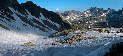
![Looking down the 5 Lakes Valley while climbing to Szpiglasowa Przełęcz]() Looking down the 5 Lakes Valley while climbing to Szpiglasowa Przełęcz
Looking down the 5 Lakes Valley while climbing to Szpiglasowa Przełęcz
The snow comes an abrupt point, where the scabrous trail already owns a fixed chain. I attach crampons to the bag, and quickly reach the pass of Szpiglasowa. More than a path, there is a summit to visit there, the neighboring peak of Szpiglasowy Wierch, just 100m above, with a small way-and-back on the ridge. It tops at 2172m, and just like Świnica is a remarkable point of view.
Have I told about altitudes? These stories of via ferratas, crampons and so on might make you smile, in this environment of peaks evolving between 2000m and 2500m. However, we are in a very mineral and alpine scenery. By observing the vegetation levels, not only these days but during all my trips, I am estimating that there is about 700m of difference with the Pyrenees. The highest hooked pines reach 2500m; here, the mantle of dwarf pines disperse beyond 1800m. Świnica had the look and class of a great 3000, about Szpiglasowy Wierch, it easily slips on the clothes of a peak in 2700 or 2800. The explanation is related to geography and climate, as we are located further north, as a comparison to the latitude of Normandy.
![Climbing to Szpiglasowa Przełęcz]() Climbing to Szpiglasowa Przełęcz... first use of my ice-axe in Poland
Climbing to Szpiglasowa Przełęcz... first use of my ice-axe in Poland
It is 8am, I have all the summit to myself. Szpiglasowy Wierch offers a first class view, to the Five Lakes, now under the shadows of emerging clouds. On the West, the slovak side, a superb view goes down into the valley Kôprová dolina ("Dill Valley") and the glacial lake Nižné Temnosmrečinské pleso. And finally, on east side, on the third great valley whose exploration was the purpose of this expedition in the Tatras: Dolina Valley Rybiego Potoku ("Valley of the trouts stream"), more commonly known as the Morskie Oko Valley, after the great lake it contains.
Morskie Oko is the most emblematic place in the Tatras. If you skip the indictment about it being overcrowded, whose beginning of this trip report gave a foretaste, here is a brief overview:
The "eye of the sea", as its name indicates, combines the superlatives. This is the broadest glacial lake in the Tatras, the deepest as well. Located in an enclave hemmed in, quite on the contrary to the Valley of 5 Lakes, this accentuates its spectacular location. This is one of the only lakes to be located as low as the forest level, also a quite notable fact to be mentioned for a lake of this size. This is the reason why its shores are so beautiful.
![Looking down the 5 Lakes Valley while climbing to Szpiglasowa Przełęcz]() Looking down the 5 Lakes Valley while climbing to Szpiglasowa Przełęcz
Looking down the 5 Lakes Valley while climbing to Szpiglasowa Przełęcz
Probably from the blue ocean tones of its depths are at the origin of his name, with the associated legend, which tells how it is linked with the Adriatic sea underground would bind through conduit underground, to the Adriatic Sea. The legend also tells about how were found there the remains of a ship, and a chest of precious stones and other remains, having sunk precisely in the Adriatic ...
Since I earlier made comparison a comparison between Colomers and the 5 Lakes, let's make a new one between Morskie Oko and Lac d'Oô. The comparison applies also due to the fact Morskie Oko is seconded by a second lake nearly as large, further upstream, Lake Czarny Staw pod Rysami (Oô's Espingo in closer). Let's add that above Czarny Staw pod Rysami, starts the route that climbs to the peak Rysy, 2503m, highest point in Poland (but not in the Tatras), on the border.
From Szpiglasowy Wierch's top where I still stand, I perceive the reflection of only a portion of Czarny Staw, still in shadow, but as as I get off on a long winding trail, the site reveals itself. What a chance to get introduced with this world-wide known site for the first time of my life and from above, in the quiet morning, instead of rushing through the parking lot and the asphalted road !
Half way down we come into a deep secondary valley, where lie two small glacial lakes, that partially got rid of their winter ice cap. Dressed warmly since I left, I take a break, since I start to melt as I descend in slopes heated by the sunlight. I skip crampons, gaiters and jacket against shorts and sun cream.
Then I decide to go ahead a bit towards small lakes and the end of this steep corrie, just by curiosity. There is a large steep couloir still snowy, in which the path normally continues, a cul-de-sac on a border pass: Wrota Chalubinskiego. This passage gives access to the two slovak lakes of Temnosmrečinské plese, but unfortunately, the final portion of the trail is prohibited Slovak side, the official trail stopping only to the lake. I will get back to this topic later.
![Lake Staw Staszica in Dolina Mnicha, and pass Wrota Chałubińskiego]() Lake Staw Staszica in Dolina Mnicha, and pass Wrota Chałubińskiego
Lake Staw Staszica in Dolina Mnicha, and pass Wrota Chałubińskiego
Then I meet the first group of hikers of the day, walking up the main trail. Another thing that makes this place popular, is that this valley provides access to "Mnich." The "monk", its name, is a spectacularly sharp pinnacle, particularly prominent when seen below from the Lake Morskie Oko. All climbers are soon or late attracted by this needle go to climb it, mostly from behind or more rarely via the longer vertical drop.
Meanwhile, the first rays of sun appear, strong as projectors, lightning the depths of the lakes Morskie Oko and Czarny Staw, whose emerald tones I see clearly now. The descent dips towards the northeast, through the forest, to reach the spillway of Lake Morskie Oko, where stands the mountain hut. As I reach it, there is still very few people, despite the terrace bar is completely filled. It is still early, 10am, and I decide to to visit the lake above, Czarny Staw, performing at the same time a loop around the Morskie Oko shores.
![Morskie Oko and Czarny Staw pod Rysami]() Morskie Oko and Czarny Staw pod Rysami
Morskie Oko and Czarny Staw pod Rysami
I walk along the east bank first, because the opposite side is still in the shadow. It goes along small creeks and small promontories where the trees are growing to the very end. The water is emerald, the atmosphere is enchanting, like somewhere in Canada's Rocky Mountains. And there's hardly anyone ...
As I reached the opposite end, I start to climb the short steep section that leads to upper lake, Czarny Staw. My legs are starting to really get their fix, and the beginning is hard... what a pity I can not abandon temporarily my backpack here, as I did on Kościelec! 250m later, I am on the edge of Czarny Staw pod Rysami, also with a winter remain, an island of ice shaped like a crescent moon, which moves slowly in the wind.
![Czarny Staw pod Rysami]() Czarny Staw pod Rysami
Czarny Staw pod Rysami
The location is awesome. All around, we are dominated by a rocky overhangs with walls of 800m! The raising clouds have eventually merged to form cumulus that hang permanently on the high peaks, hiding the sun. The granitic boulders of this chaos are gloomy dark. No doubt about the etymology of "Czarny Staw," the "black pond". If Morskie Oko reminds of the Adriatic, this one rather inspires the Norwegian Fjords!
"Pod Rysami" because the Black Pond is located under the peak Rysy. Although not the highest of the Tatras he belongs to the club of the largest in the range, over the 2500 barrier. Very popular during the summer season, the access is still tricky during this time of the year. My eyes wander on the opposite shore of the lake, and I begin to follow the path with my eyes, which later attacks a steep portion of laces, then moves to the left along a wide flat stretch of mountain on a long steep slope. Near the end, the summit concludes through an area I easily imagine equipped with chains.
![Czarny Staw pod Rysami]() Rysy over Czarny Staw pod Rysami
Rysy over Czarny Staw pod Rysami
Snow covers a lot of places, and softens during this precise moment of the day. Nevertheless, from the picnic crowd that grows around me at the lake, I see regularly see people venturing on the trail without equipment. I also see far more, much further on the way. Some come back after some hesitations, some others continue, seeming to say "let's go as high as we can.". The evening after my return from the Tatras, I learned that a teenager made a fatal fall by sliding on the snow, just under the peak Rysy...
As for me, this visual recognition fully satisfied my curiosity for today. It is planned since some time that we give Rysy a visit, my girlfriend and I, at the end of the Fall, when weather conditions are most favorable, and by spending a night at Chata Pod Rysami, the highest refuge Tatra, 250m below the top Slovak side. I also dream about the opportunity to take sunsets and sunrises in photo, from the top. A business for sure with some romance !
![Lake Morskie Oko, still in the quietness...]() Lake Morskie Oko, still in the quietness...
Lake Morskie Oko, still in the quietness...
Rysy is not the only path that goes from the lake. Right, another path, just as perilous, climbs toward Mieguszowiecka Przełęcz; this is also a high breach overlooking Slovakia, like Wrota Chalubinskiego, but unfortunately with no continuity on the Slovak side. This would allow to access to the valley Mengusovská, and the large lake Hincovo pleso, Morskie Oko's alter ego and largest lake Slovak Tatras.
There is yet another example of this scenario with the pass Gładka Przełęcz, under the peak Świnica, as well as the continuity of the green trail leading to the pass Liliowa.
And here we come to my little "rant" ... Why so many border crossings, which mean as many possibilities of interesting loops for hikers, are not possible? Officially it is forbidden to in order to preserve the wildlife, the flora ... but for the last instance, only 200m of extra trail is needed ! Is it not just an excuse, especially when trail-running races that reach Morskie Oko and Murowaniec are being held ? (having said that I have nothing against runners)
The real reason is that Slovakia and Poland, who just joined the Schengen area, are afraid about the fact that borders have become out outdated notion in mountains. The Polish Tatras are most popular and the Slovak TANAP (Slovak National Park), is evidently fearing an uncontrolled influx of polish tourists, and seeks at all costs an excuse to "contain" the wave... This explains why until recently only two border crossings were officially open (Rysy and Wolowiec).
Surveys show that these fears are unjustified. First, it is perfectly possible for Poles to go start his tour in Slovakia. On the other hand, only a negligible percentage of hikers perform several-days trans-border circuits. Hopefully the TPN and TANAP understand each other better and better, and the "hypocrisy" of protected trails will end...
![Lake Morskie Oko, still in the quietness...]() Lake Morskie Oko, still in the quietness...
Lake Morskie Oko, still in the quietness...
Here I am, back in Morskie Oko, walking back through the other side where the hut is. By 1:30pm, the place is unrecognizable. I am struggling to find my way and extract myself from the terrace by the lake. Dozens of tours (you can ride there in a carriage) filled the place with hundreds and hundreds of people, all in the same distress, that look and call themselves, camera in hand, looking for the toilets, looking for food, searching a husband or children, in an indescribable stampede...
I have more water in my bottle, and decide to go in the hut's taps to check if the water is drinkable. Hundreds of people go in and out, like in the metro. I reach the toilets in the basement, where a sitting woman is charging everyone, like in Macdonalds. A wind of panic blows, even till here. I explain her that I just fill my bottle, which she accepts in a burst of patience ...
I then extract myself again, then I spawn again a passage out towards the asphalted road, along which the crowd density gradually decreases, and which I move away without giving me respite for a few minutes.
Obviously, it is about the "Morskie Oko problem" that we need to speak. How a bank of a mountain pond can it host the same crowd as the Eiffel tower ? It is impossible to regulate the rumours from mouth to ear, which now extends widely abroad, with the growing popularity of Poland as a tourist destination...
What to do? Close the road to the carriages, which would deprive the disabled ones of the best views? Highlanders eyes are as worth as newcomers eyes. Limiting the access to the lake with quotas ? Opening hours ? A higher price to the park entrance? More promotion for other parts of the range ? Nobody has the answer, nobody knows how to contain and stabilize the traffic in the site of Morskie Oko.
I go down the whole Morskie Oko road during 1h and a half, and I keep meeting more crowd, going up again and again... even if the sky starts to get dark, behind me.
The construction of this road dates back several decades ago and is now forbidden for private use, as it is everywhere in the park. Moreover, it is falling in pieces, the railing is half buried in the abyss below, and landslides have washed away some parts of the coating, in places over half of its width.
![Dolina Rybiego Potoku.]() Dolina Rybiego Potoku under stormy clouds...
Dolina Rybiego Potoku under stormy clouds...
Near the end, the valley of Morskie Oko and the valley Bielovodská merge into one, the river that runs through the center serves as the Polish-Slovak border. For the Polish hikers, it is impossible to bifurcate at that point and go up the other valley. The Slovak hiker is not able to sleep at the shelter Roztoka, located at the confluence of the two, but on the Polish side. Instead of that we must walk down, several miles below to reach the road-border Łysa Polana, if we want to switch from one to another. That's a last nonsense which persists, just like all the previous described above...
I'm finally back to my car, glowing like a solar oven. I have neither the strength nor the will to make a fourth day of hiking, and besides, the stormy weather is announced for Sunday. Today's storm begins to dawn, cumulus black as ink have flooded the heights. I stop at Tatranska Bukowina, where I buy an excellent "Oscypek" smoked sheep's cheese from the Tatras from an old woman on the roadside, and I'm off to Wrocław, to which a 4 hours drive is waiting, punctuated by showers and lightnings.
This concludes my trip, and while my eyes are following the dotted highway paintings, I am meditating about that trip that I consider quite positive.
Conclusion
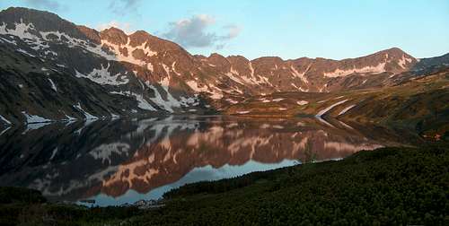
![Sunrise in the Valley of the Five Lakes, around 5am, absolutely alone]() Sunrise in the Valley of the Five Lakes, around 5am, absolutely alone
Sunrise in the Valley of the Five Lakes, around 5am, absolutely alone
The Polish High Tatras are made of paradoxes and contrasts. We have a very small part of the whole range, but which actually includes a good number of its most remarkable characteristics.
This is arguably the greatest treasure if we speak lakes, and the most original sites of the range. Czarny Staw Gąsienicowej, Wielki Staw, Morskie Oko, Czarny Staw pod Rysami, are the four largest lakes in the Tatras. Beyond their size, the location in which they lie, are extraordinary sites that draw curiosity questions, and can't leave indifferent.
More than the supposed sunk treasure, the Tatras lakes are the gems themselves, and it is easy to understand how the Polish Tatras have inspired generations of artists during all times.
![Sunrise in the Valley of the Five Lakes, around 5am, absolutely alone]() Sunrise in the Valley of the Five Lakes, around 5am, absolutely alone
Sunrise in the Valley of the Five Lakes, around 5am, absolutely alone
Humanly speaking, the paradox is at least as large. On the one hand, we have this uncontrollable crowd, this tide of tourists not always cautious, this tiny National Park experiencing all these phenomenons, forced to deal with complex dilemmas. Despite this, the Tatras still and always keep their magic, always exert the same fascination, keep the same conviviality.
It is possible to make extraordinary encounters, unforgettable moments even coming alone. There will always be the "Taterniks" (translate : Taternists), as we call this fragment of the population that are mountain-enthusiasts, this healthy emulations that results from it, based on fundamental values such as respect, sharing, and the love of nature. This small fragment of mountain range, these three valleys, have produced and still produce many Hymalayists and other world-renowned mountaineers.
For all these reasons, the Polish High Tatras mountains are full of charisma, that everyone should visit one day. May they keep their magic a long time.
![Sunrise on Swinica in the Valley of the Five Lakes, around 5am, absolutely alone]() Sunrise in the Valley of the Five Lakes, around 5am, absolutely alone
Sunrise in the Valley of the Five Lakes, around 5am, absolutely alone


Comments
Post a Comment