Introduction
When I can't be in the mountains, I love to look at maps of them. Interesting features and possible routes are things that grab my attention, and I have spent many hours with many different types of maps. It goes back to my childhood, when I pored through at atlases and found myself especially interested in mountain ranges, glaciers, deserts, and the courses of rivers. Even maps of ocean floor, a place I knew back then I would probably never see, inspired my imagination.
Studying my Shoshone National Forest North Half map back in 2000, I "discovered" Kirwin. What I saw was a mining area located at the end of a 4wd road deep in the Absaroka Range. At the time, I had no idea that Kirwin was a ghost town and that the area mines were ruins. The things that mattered were these:
* Almost everything out there was on public land.
* From road's end, trails climbed no more than five miles to three different high named passes that I knew required approaches of up to 20 miles from other directions.
Kirwin became a place I had to go to, and it found its way into plans for my August 2001 Wyoming trip.
What follows is a photo trip report documenting my first visit to Kirwin. There was no mountaineering, only hiking, but the visit kindled a fierce desire for future outings. This trip report is the first in what will be a series devoted to my adventures out at Kirwin, a place that has vaulted high on my list of favorites.
East Fork Pass
My wife and I picked a perfect day for our first taste of Kirwin. It was a warm, sunny day with cotton-candy clouds. The weather was never even close to as good our other days out there.
Why we chose East Fork Pass as our first destination I can't remember, but that's where we went, and both of us were stunned by the beauty of the scenery. The Kirwin area was so spectacular that we called to cancel our two-night reservation in Cody and changed our stay in Meteetse, the closest town to Kirwin, from two nights to four (we also got a suite-style room at the Vision Quest Motel for about $40 a night, which was around half of what we were going to be paying for a regular room along a construction-plagued street in Cody).
![Mount Crosby]() Mount Crosby on the other side of the Wood River valley, as seen from the hike to East Fork Pass. The lower peak is Point 11,508; information about it can be found on this route page.
Mount Crosby on the other side of the Wood River valley, as seen from the hike to East Fork Pass. The lower peak is Point 11,508; information about it can be found on this route page.![East of East Fork Pass]() East of East Fork Pass; it is easy to traverse to this unnamed peak from the pass.
East of East Fork Pass; it is easy to traverse to this unnamed peak from the pass.![West from East Fork Pass]() Looking north from East Fork Pass. Traversing north will get one to the summit of Point 11,694. The peak seen here is not the summit of Point 11,694.
Looking north from East Fork Pass. Traversing north will get one to the summit of Point 11,694. The peak seen here is not the summit of Point 11,694.Greybull Pass
For our second Meteetse day, we drove up to Cody and then along the Dead Indian Highway, which I'd been on once before but my wife had never seen, and we did a pleasant hike along a canyon rim out there.
The next day, though, it was back to Kirwin. If I remember correctly, the weather was lousy and we spent much of the day wasting time in the motel room, but when some clearing began in the afternoon, we scrambled to the car to begin the 90-minute drive to Kirwin, hoping to get there with time to do something. Ultimately, my wife decided to enjoy the improving weather and hang out near the car and read, and I chose to hike to Greybull Pass, the highest of the named passes and the shortest to reach.
Conditions worsened but held, and I was able to enjoy one of the most spectacular day hikes that Wyoming has to offer, a short, steep jaunt to clear the trees and then a hike through austerely beautiful Brown Basin up to the pass. Greybull Pass is a spectacular destination all on its own, with views deep into the wildest parts of the Washakie Wilderness. There are also several pinnacles and gendarmes flanking the north side of the pass; what looks so gentle from Brown Basin has an entirely different character on its other side. It's a tiring 2-3 miles to the pas but totally worth it.
The Greybull River, by the way, gets its name from a Native American legend about an albino bison.
![Francs Peak]() Francs Peak, highpoint of the Absaroka Range, from Greybull Pass. One of just a handful of 13,000' Wyoming peaks outside the Wind River Range, Francs is also the only Absaroka 13er. Francs is not a Kirwin peak, but the standard approach begins a few miles from Kirwin.
Francs Peak, highpoint of the Absaroka Range, from Greybull Pass. One of just a handful of 13,000' Wyoming peaks outside the Wind River Range, Francs is also the only Absaroka 13er. Francs is not a Kirwin peak, but the standard approach begins a few miles from Kirwin.![Brown Mountain]() Brown Mountain seen from Greybull Pass. Three times, I have been on or near Brown Mountain, and each time the weather has been like this. Fortunately, I have made the summit and can now stop tempting the lightning there.
Brown Mountain seen from Greybull Pass. Three times, I have been on or near Brown Mountain, and each time the weather has been like this. Fortunately, I have made the summit and can now stop tempting the lightning there.![Yellow Ridge]() Yellow Ridge, northwest from Greybull Pass across the headwaters of the Greybull River; this peak is typical of the broad, plateau-like summits common to the southern Absarokas.
Yellow Ridge, northwest from Greybull Pass across the headwaters of the Greybull River; this peak is typical of the broad, plateau-like summits common to the southern Absarokas.![Greybull Pass View]() West-southwest from Greybull Pass towards the trickling beginnings of the Greybull River, later and lower on a major stream that is often difficult or impossible even for horses to ford.
West-southwest from Greybull Pass towards the trickling beginnings of the Greybull River, later and lower on a major stream that is often difficult or impossible even for horses to ford.Bear Creek Pass
On the last Meteetse day, the weather once again wasn't nice, with rain and thunder in the morning, so we again waited until the afternoon to head up. This time, my wife joined me on the hike to Bear Creek Pass, but she eventually decided not to go all the way, so I surrendered the pepper spray (somehow, I haven't mentioned yet that the Absaroka Range is thick with grizzly bears) to her and proceeded alone.
The hike to the pass was much like that to East Fork Pass; once the trees are gone, you follow a faint trail through lovely meadows that are steeper than they look until you reach the windswept dirt slopes of the pass itself. Deteriorating conditions kept me from staying long, but I did have time to get it into my head that I might like to return to make a traverse between East Fork and Bear Creek Passes, and in 2007 I did go back for that exact purpose. But that's for Volume 2.
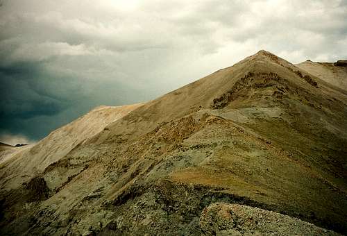
![West from Bear Creek Pass]() A view west from Bear Creek Pass. The weather wasn't great and neither is the picture, but you can still see the wild, lightly traveled country that is just all over the place out here.
A view west from Bear Creek Pass. The weather wasn't great and neither is the picture, but you can still see the wild, lightly traveled country that is just all over the place out here.


Comments
Post a Comment