Overview
![Ishawooa Mesa]() Absaroka majesty
Absaroka majesty
This trip report will not have any epic summit pictures or tales of heroic deeds done while climbing massive mountains, mainly because my climbing partner Doug and I didn't make any summits or climb any massive mountains. Obvious statements aside, we did set out on this trip with the intent of climbing one of the remote peaks in the rugged
Southwest Absaroka Range of northwest Wyoming, but we ended up having to turn back due to super slow progress in the deep snow and some definite avalanche potential. In spite of the fact that we failed in climbing anything, it was a great experience in a supremely beautiful place!
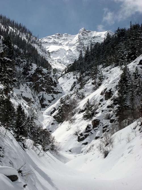
![Unnamed peak]() An unnamed peak from the Deer Creek Trail
An unnamed peak from the Deer Creek Trail
Doug was the one who first came up with the idea of trying Kingfisher Peak after a solo ice climbing trip he took in February in the Deer Creek drainage up the South Fork near Cody, Wyoming. The route to Kingfisher starts near the end of the South Fork road at the Deer Creek trail head at 6400 feet; the trail goes for about 11 miles to Deer Creek Pass at 10,400 feet, and then it's about a mile off trail to the summit at 11,035 feet. This looked pretty feasible considering that the overall snow totals for the winter were down a little bit and we'd been having relatively warm weather throughout the month of March. We only had two days for the trip due to differing schedules, so the plan was to camp just below the pass the first day and summit early the second day in order to be out by dark.
Day One
![Moonset over the South Fork]() Moonset over the South Fork
Moonset over the South Fork
On Wednesday, March 31, a big storm moved in over the mountains and deposited snow over much of the
Big Horn Basin down to elevations as low as 5,000 feet; the snow was supposed to let up Thursday night, and when we reached the trail head at dawn on Friday morning, it was a beautiful clear morning with temps in the mid-teens and about four inches of fresh snow on the ground. We figured we'd give it a go in spite of the new snow and see how far we got by early afternoon before making a decision about whether to try and go all of the way.
The trail gains about 1,000 feet in the first mile of switchbacks, so we were plenty warm within minutes of starting out. We enjoyed watching a couple of Big Horn sheep playing near the trail before rounding the corner that gives a great view over 8 miles back up the drainage.
![Big Horn sheep]() Big Horn sheep
Big Horn sheep![Deer Creek Valley]() The Deer Creek Valley
The Deer Creek Valley
This area has one of the greatest concentrations of frozen waterfalls to be found anywhere, and almost every small waterway that comes off of the steep, rugged cliffs was filled with spectacular ice. One drops well over one hundred vertical feet just below the first stream crossing, which we crossed on a solid snow bridge.
![Frozen waterfalls]() Awesome ice
Awesome ice
At about 7800 feet, the trail meets Deer Creek and crosses to the south side of the water and onto north side of the huge ridge that extends east from Kingfisher for about ten miles. The crossing wasn't too bad; Doug punched through the snow into the shallow water on the far side, but stayed dry thanks to his Scarpas. I avoided this section by entering and becoming entangled in a thicket on the south banks, which resulted in a few frustrated utterances by me and much laughter from Doug at my predicament!
![Crossing Deer Creek]() Doug crossing Deer Creek
Doug crossing Deer Creek
We switched to snowshoes soon after this once the snow depth starting reaching two feet in some places along the trail. Doug was a superman and broke trail for a couple of hours until lunch and then more after we found out that my shoes with short tails were worthless for breaking trail in the fresh powder. We encountered three fairly fresh avalanche debris fields that had come off of the ice in the gullies above, so the 12+ inches of new snow had definitely upped the slide potential.
![Avalanche field]() Avalanche field
Avalanche field
We had identified 2:00 p.m. as a turn-around time for bailing and getting out to the car that night; we found a good campsite at 1:45 and decided that since we were both feeling good and the weather was holding, we would try and continue on with the plan of camping at that place if we turned around later. About an hour later, our progress had slowed to less than half a mile per hour in snow that was three and four feet deep in places and the trail had led us onto the side of a slope that was about 35 or 40 degrees. We were still making steady but slow progress when we felt the snow go whoomph and drop us a couple of inches. There was a large fracture line well above us on the slope and a slab about 20x10 feet had broken loose, but it was thankfully still sitting on the hill. I backed up until I was behind the line and waited for Doug to reach the group of trees before I crossed and joined him. A couple of minutes later, while Doug was crossing the next open section, a similar slab broke audibly around him and moved about an inch downhill. We figured this was a sign, and considering that we still had at least another hour on the slope before we could get out of the avalanche danger, we decided to give up the ghost on the attempt and retreat to the campsite we'd found earlier.
![Doug at the end of our trail]() The end of the road
The end of the road
We reached camp at about 3:30 and stamped out a big area before assembling the tent and boiling water for tea and dinner. A few snow flurries moved through before the sun set, and we played some Texas Hold'em in the tent before settling in about 9:00.
![Camp]() Boiling water at Camp
Boiling water at CampDay Two
![Morning snowstorm]() Morning snow
Morning snow
We awoke to steady snow and about an inch of new accumulation on the tent; the valley was clouded in and it was pretty cold as we cooked our oatmeal and packed up camp. We were on the trail about 9:00, and we made quick progress down as the snowfall got heavier. There were several places where the fresh snow and wind had obliterated our tracks from the day before, but it wasn't difficult to stay on course.
![Snow and more snow]() The hike out in the snow
The hike out in the snow![Deer Creek Trail]() Me above the biggest waterfall on the Deer Creek Trail
Me above the biggest waterfall on the Deer Creek Trail
The snow bridges on the two stream crossings held us again and were much easier in the snowshoes, which we kept on until the top of switchbacks above the trail head. A larger group of sheep were hanging out near the top of the switchbacks, and we were able to cover the 6 miles out in just over three hours, reaching the car at 12:15.
![More sheep]() More sheep
More sheep
We enjoyed some big burgers and some excellent Red Lodge brews at the Proud Cut in Cody to bring the trip to a close. We're definitely planning on returning this summer to bag Kingfisher and some neighboring peaks when there's no snow!
![Carter Mountain]() Carter Mountain
Carter Mountain![Ishawooa Mesa]() Ishawooa Mesa
Ishawooa Mesa


Comments
Post a Comment