Commentary and Introduction
The Uinta Mountains, a vast range oriented east-west in northern Utah, offer spectacular and sometimes challenging backpacking, fishing and hiking opportunities. This wilderness area presents unique challenges to hikers wishing to stand atop one or more of the 20 highest points in the Beehive state. Having no 14ers about which to brag, Utahns must be content with 13ers. However, just because these mountain summits do not come as close to the heavens as many in the Colorado Rockies or the California Sierras, it does not follow that these “puny” peaks are pushovers or creampuffs or pieces of proverbial cake. Many of these 13ers offer uninviting if not downright boring profiles, profiles more resembling resting elephants rather than the daunting craggy outlines of, say, the Alps or the Tetons. Ansel Adams wouldn’t spend much time taking photographs of them. Kodak Moments may be few and far between. But don’t let the benign shapes lull you into a false sense of security.
Several of the more challenging aspects of these Uinta giants include longer-than-normal distances from the closest trailheads, no established trails leading to the summits and weather-related dangers in all seasons. Summers offer regular afternoon thunderstorms on their meteorological menu, and these storms can be as violent and unforgiving as a pack of rabid pit bulls. Bone-chilling temperatures and merciless winds combine to make winter travel into these remote locations not only miserable but downright dangerous; unplowed roads make already long distances to the peaks even longer.
Yet thousands willingly venture into the Uintas each year, primarily in the summer months, to enjoy the serenity, the solitude (except on weekend summit days for Kings Peak) and the broad vistas of the glacially dug basins and the quartzite-clogged humps and cliffs of the loitering mountains. Streams, ponds, marshes and lakes abound; conifer forests carpet the lower elevations. Mosquitoes take to the air like hoards of miniature kamikaze squadrons during late June and into mid-August just to test the mettle of those who dare to venture into these wilds.
There are a few of us who might label ourselves as peak baggers. Not to be confused with carpetbaggers, we seek those often elusive highest points on mountains, those sometimes disputed points which cartographers designate as being the “roof” of a continent, country, state or county. I don’t mind admitting that I am a peak bagger, but I hope I have not allowed it to become an obsession. All right, I admit that it is more than a hope or a wish; it’s a channeled craving for which I have created reins of reason.
My previous Uinta 13ers all have one thing in common: I have done them in a single day from the closest trailhead. With ZeeJay’s able assistance I was able to knock off three in a day; with Dave the Robot I bagged two toughies in a day. And once, solo, I bagged another two with a very long single-day effort, those being Mt. Emmons and South Emmons from the Uinta trailhead. Kings Peak is one I have done several different ways including a foray in the winter on skis which turned out to be an embarrassing debacle of sorts. I even did West Gunsight Peak in a single day on snowshoes, a report of which you can read as a trip report for the Kings Peak page on SP.
As this year began I was still facing the same task I had faced as 2012 began: I needed four 13ers to complete the run of the Uinta table. Yup, climbed not a single 13er in 2012. Bad, bad boy. Just didn’t focus and planned too much other climbing when the times had been right. So I made up my mind I would make a more refined effort in 2013; with planning and resolve I could somehow get at least a couple of those big buggers off my list of un-climbed 13ers.
The peaks which had eluded my lackadaisical efforts were those in the middle of the vaunted Kings-Emmons Ridge. I had picked off Kings and South Kings from the north, and I had conquered Emmons and South Emmons from the south. So that left just the four (or five according to David Rose in his book “Utah Thirteeners”) smack in the middle of this over-sized pachyderm-like chain of rock piles. I was resisting the urging of many to break my own “rule” and just backpack in, camp and then hit them from a high camp. Much easier in the grand scheme of things, they said. Perhaps they are right. But I wanted to see if I could continue the trend and say that I had done them all with blitzkrieg tactics.
Then I came across ZeeJay’s fine entry titled “The Northern 4 Peaks.” What a stroke of genius her report was. She is undoubtedly one of the foremost experts on the Uintas and has spent more time there, skiing and hiking, than anyone else I know. Her saga of a one-day march which allowed her to top four of the northern 13ers is wonderful reading. Her pictures are expansive and her short detailed descriptions are on the money. There it was – a template for allowing me to summit at least two of the missing 13ers in a single day.
My first order of business was to get additional information from her, and she was kind enough to supply it in rapid fashion. The second order of business was to see if I could find someone who would like to do it with me. ZeeJay had done it solo, and I thought I could probably do it unaccompanied, also, but having someone with whom to share the misery seemed a more inviting method. I have a good friend, Brent, who loves to hike in the summer but despises winter adventures in the mountains. Luck was with me the day I asked him what he thought about the idea of tackling the Northern Four. He threw his hat into the ring. Hooray, a partner in crime. And this in spite of his excruciating experience two years ago in doing Mt. Emmons when his inner fuel reserves hit an all-time low and he came back to our Uinta trailhead camp nearing exhaustion.
With maps and notes and continued encouragement from ZeeJay we made our plans to take three days for the adventure: (1) drive to the Henrys Fork TH and camp, (2) start the next morning at four o’clock, complete the round trip and sleep, (3) get up the third day, tear down our camp and drive home. Now all we had to do was find a decent weather window. We defined “decent” as a forecast indicating, at the worst, a slight chance of afternoon thunderstorms. We would not accept a 20% chance or anything higher. Being finicky like this caused us to postpone our departure by two days, and we were satisfied we had made the right choice.
Drive to the Henrys Fork trailhead and set up camp.
The drive to the trailhead was uneventful. There were big boomers – towering cumulus with darkened foreboding underbellies - over the Uintas as we cruised into Evanston, Wyoming, on I-80. Not to worry, we hike tomorrow! Familiar wind turbine clusters swung their white pinwheeling blades, all of them rotating lazily in rhythm with an afternoon westerly breeze. Construction delays outside of tiny Mountain Home were slightly aggravating but what’s a body to do?
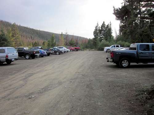
It was a Wednesday, so we figured we might have the trailhead to ourselves. Silly us! Not only was the main parking lot full but the overflow parking was filled and there were lines of parked cars on both sides of the road leading to the main lot. What the? But miracle of miracles, all four of the camping sites were still available; apparently everyone who had parked had decided to backpack in rather than do something stupid like try for Kings Peak in a single day!
![The Northern Four (5)]() Although we arrived on a weekday the main and overflow parking lots were full. However, all 4 picnic-tabeled camping sites were unclaimed!
Although we arrived on a weekday the main and overflow parking lots were full. However, all 4 picnic-tabeled camping sites were unclaimed!
License plates from West Virginia, New Mexico, Idaho, Arizona and many other states were evidence that a state highpoint was beckoning. We looked at the trailhead register and saw that 99% of the entries in the column labeled destination said “Kings.” I scrawled our entry and entered, dutifully, “Kings and 4 others.” In the column titled number of days I nearly laughed when I wrote “one.” All of the other entries in that column were either “three” or “four.”
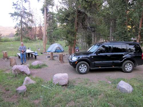
![The Northern Four (5)]() Car camping means just what it implies: get the vehicle as close as possible to the campsite and count your blessings!
Car camping means just what it implies: get the vehicle as close as possible to the campsite and count your blessings!
With our tent set up and our picnic table decked out with the comforts appropriate for car camping we attempted to settle in and go to sleep about 8 o’clock, twenty minutes before official sunset. That was a joke, but not because anticipation held our sleep at bay. No, another group pulled into the camping site 20 yards away and proceeded to laugh, guffaw, shriek and even sing until very, very late. A bit frustrating it was, and at one point Brent politely asked them if they could please tone it down a notch or two. Our GPS alarm was set for 3 a.m. and I believe with all my heart that I might have gotten four hours of shuteye before that little tweeting-twittering alarm began its appointed task. Brent claims to have maybe bagged two or two three hours of sleep. To turn a phrase, it was what it was. D-day had come; our lot was cast and this was no time for sissy wimps.
Starting the one-day trek and bagging Kings Peak.
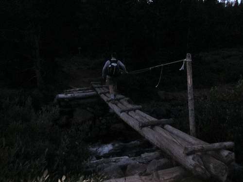
We were on our way by 4:05, headlamp beams penetrating the cool darkness enveloping the north end of the Henrys Fork basin. The trail parallels Henrys Fork Creek, climbing gently up from it and meandering here and there as it forges its way through lodge pole pines and over rocks and boulders firmly embedded in the ruddy dirt. Small tributaries dampen sections of the trail and a number of weathered wooden bridges, some as short as three feet, span particularly wet sections. We made good time in spite of the darkness, reaching Elkhorn Crossing in just over 2 hours. It was at this point that we both noticed the chilling air draining along the creek bed; frost was covering the spindly grasses and ground-level stones next to the trail. No wonder my hands felt like ice sculptures.
![The Northern Four (5)]() We are at Elkhorn Crossing a few minutes after 6 a.m. Basin drainage breezes feel very cold with the outside air temperatures near 35 degrees. This bridge is 100 yards upstream from the one which was washed out a couple of years ago.
We are at Elkhorn Crossing a few minutes after 6 a.m. Basin drainage breezes feel very cold with the outside air temperatures near 35 degrees. This bridge is 100 yards upstream from the one which was washed out a couple of years ago.![The Northern Four (5)]()
Up and out of the lowest part of the basin we begin to enjoy early morning views of the nearer Uinta 13ers.
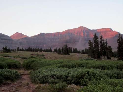
![The Northern Four (5)]() The finest beauty of the Uintas is often captured at sunrise and/or sunset. Shown here in early morning light, Henrys Fork Peak and Cliff Point hog the spotlight while Kings Peak is the pointy peak to the left of the photo.
The finest beauty of the Uintas is often captured at sunrise and/or sunset. Shown here in early morning light, Henrys Fork Peak and Cliff Point hog the spotlight while Kings Peak is the pointy peak to the left of the photo.
We were doing our best to keep pace with ZeeJay’s times. Just before crossing the creek at Elkhorn Crossing we were able to turn off our headlamps, and the gentle rays of a new day kissed the tops of several of the closer 13ers as we ascended up to the portion of the trail leading us past Dollar Lake and eventually to Gunsight Pass. With peach-warm velvet tones softening the east flanks of Henrys Fork Peak, Cliff Point, Mt. Powell, West Gunsight and Kings Peak the far-away mountains seemed to be saying in unison, “We’re not so bad. Come, have a closer look.” Now out of the lowest part of the basin, we reveled in the warmer air; the drainage breezes were gone. We quickened our pace and began spotting colorful tents here and there as we approached the treed Dollar Lake area and beyond. “Glad that someone else hauled those tents up here,” I mused.
Ah, Gunsight Pass and only a quarter of an hour behind ZeeJay’s time. But this relatively small time deviation was an omen of things to come, a somber reminder that not only is she a fast tenacious hiker but our times would probably always be a bit slower than hers. I immediately began calculating the additional minutes here and there and decided that if we made it back in 18 rather than 17 hours we would be extremely fortunate. As you will see, my estimate would be conservative but not laughably irrelevant.
![The Northern Four (5)]() Standing at Gunsight Pass we note that our elapsed time is 15 minutes longer than we had hoped. We'll take the Gunsight Cutoff route, a portion of which is behind us in this photo.
Standing at Gunsight Pass we note that our elapsed time is 15 minutes longer than we had hoped. We'll take the Gunsight Cutoff route, a portion of which is behind us in this photo.
Taking the so-called Gunsight Cutoff or Shortcut we scaled the imposing steep east flank of West Gunsight Peak by following a rocky trail marked 80% of the time with cairns, a few ornate but most of them banal and unpretentious in an ugly sort of way. This shortcut shaves off at least a mile compared with following a trail leading first into Painter Basin and then back up and northwest to Anderson Pass. At the top of the headwall we made a beeline across a gently sloping plateau toward the familiar knob delineating a point just north of Kings Peak’s summit. Taking this line meant bypassing Anderson Pass, and we hoped that the pass wouldn’t take it personally. We crossed a small brook, our final chance for fresh water, but at the time we didn’t need it. The rocks and slabs and boulders on the east face of Kings are quite stable and allowed us slow but steady and safe progress as we climbed up the 1,200’ of them. I had collapsed and stashed my trekking poles in my pack during our short break at Gunsight Pass and would not take them out until 4 o’clock that afternoon.
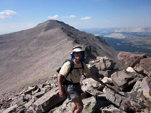
![The Northern Four (5)]() Now above the dicier part of the Gunsight Cutoff, Brent begins the direct route across this sloping plateau toward the east face of Kings. We will maintain this direct route all the way to the Kings summit.
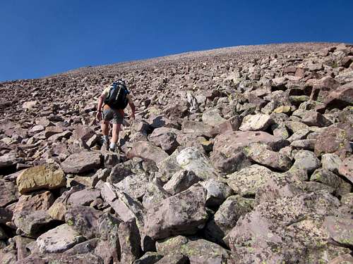
Now above the dicier part of the Gunsight Cutoff, Brent begins the direct route across this sloping plateau toward the east face of Kings. We will maintain this direct route all the way to the Kings summit.![The Northern Four (5)]() We reach the base of the Kings east face around 9:33 a.m. and know that we've got over 1,200' of these rocks and boulders to navigate over and around before reaching the Kings summit. The entire thing lends new meaning to the term "rocky road."
We reach the base of the Kings east face around 9:33 a.m. and know that we've got over 1,200' of these rocks and boulders to navigate over and around before reaching the Kings summit. The entire thing lends new meaning to the term "rocky road."
As we climbed the boulder-strewn east face of Kings we looked up and often saw the tiny figures of other hikers plying the ridge along the normal route to the summit from Anderson Pass, the highest pass in the Uintas. Brent and I were taking separate but parallel tacks toward the summit, a safety measure to prevent any inadvertent rock slide from endangering either of us. By the time we reached the summit three other enthusiastic younger climbers were celebrating, several were leaving and the family of three we had chatted with at Gunsight Pass was nowhere to be seen. They had taken the shortcut ahead of us but had opted to use Anderson Pass for their approach. Our direct path, although more strenuous in nature, had given us quite the advantage in terms of time-to-the-summit.
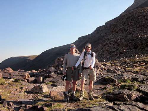
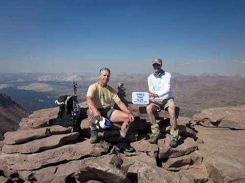
![The Northern Four (5)]() On the roof of Utah at about 6+20, still behind schedule but happy to have one peak, the highest, checked off the list. We take a short break prior to launching our quest to top out on the remaining three 13ers to our south.
On the roof of Utah at about 6+20, still behind schedule but happy to have one peak, the highest, checked off the list. We take a short break prior to launching our quest to top out on the remaining three 13ers to our south.
So there we were, on the roof of Utah, thinking to ourselves, “Ah, the thrill of victory, the grisly terror of knowing that our day was not even one third finished!” Yes, Kings Peak was the grand prize because it was the highest peak we would climb all day; but more waited for us and we would see hundreds of thousands more boulders and become a little more fatigued with each summit. We had hiked only 12 miles and knew that about 18 more miles lay ahead of us. It was a little bit like sitting at the dinner table and getting to consume a scrumptious dessert first, then realizing that those cold stringy green beans still had to be eaten. Yes, some of the work was done but the lion’s share awaited two travelers who would now leave behind the company of other hikers and who would be on their own for the next nine hours.
South Kings Peak, Painter Peak and Trail Rider Peak.
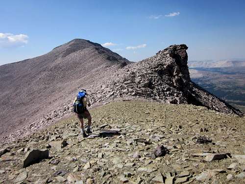
![The Northern Four]() This is the view as one leaves the comforts of Kings Peak and heads toward South Kings Peak. The boulders were stable 95% of the time.
This is the view as one leaves the comforts of Kings Peak and heads toward South Kings Peak. The boulders were stable 95% of the time.
Finding the ridge line on this gargantuan King-Emmons Ridge is quite easy. In a white-out it would be murderous, but on a clear bluebird day like we were experiencing it was simply a matter of looking generally in a southerly direction and taking a bead on the saddle between the current summit and that of the next one. Descending the potpourri of helter-skelter boulders was for the most part straight forward and without serious danger. Some of the stones would, of course, tip one way or the other, and on the steeper grades caution was a must. We were quickly reminded that this kind of hiking was mentally taxing because one could never just relax and glance heavenward while strolling merrily along. One lapse in concentration could result in a sprained ankle or worse.
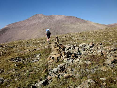
![The Northern Four (5)]() We are at the first of three short saddles between Kings and South Kings Peak. Can you see the big false summit 2/3 of the way toward the summit of South Kings Peak?
We are at the first of three short saddles between Kings and South Kings Peak. Can you see the big false summit 2/3 of the way toward the summit of South Kings Peak?
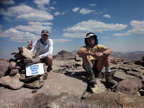
The way to South Kings Peak was easy and ate up a little more than three quarters of an hour. At this summit we found a nicely crafted waist-high cairn and next to it a golden-hued survey marker. I set up my small tripod to which I had fastened my Canon ELPH digital camera, pressed the shutter release button for the ten-second delay and hastened to position myself next to Brent for the second summit photo of the day. Then a small disaster struck in the form of a gust of wind which tipped over the tripod and camera and banged the camera’s protruding lens mount against a flat piece of quartzite. I repositioned the camera, took the picture and then found that the lens would not retract automatically when I turned the camera to the OFF position. In fact, it now would not re-extend, either, and a caution on the LCD read “lens error” and the camera was in effect shutting down for the day. I fiddled with the mechanism a couple of times, all in vain. It was a small metallic corpse, an instrument whose most noble purpose would now be to act as ballast. Well, that was a disappointment. There would be no more pictures to document our adventure. I suppose worse things could have happened, but this setback was an unsettling thought which dogged me throughout the remainder of the day.
![The Northern Four (5)]() We have now "conquered" our second 13er of the day. Our joy is tempered by a gust of wind which blew over our camera set-up, damaged the camera lens and rendered the remainder of our hike "picture-less." Refer to ZeeJay's fine report of the Northern 4 Peaks for excellent pics of the remaining peaks on our agenda.
We have now "conquered" our second 13er of the day. Our joy is tempered by a gust of wind which blew over our camera set-up, damaged the camera lens and rendered the remainder of our hike "picture-less." Refer to ZeeJay's fine report of the Northern 4 Peaks for excellent pics of the remaining peaks on our agenda.
But onward and upward, or downward, as the case was. The next objective was a “summit” but controversial as a peak since it has less than 100’ prominence. David Rose calls it Gemini Two but most purists simply call it an intermediate bump between South Kings Peak and Painter Peak. We hit it anyway since it was positioned neatly along the general ridge line leading to Painter Peak. A portion of the section between this questionable peak and Painter Peak turned out to serve up the most fun of the entire day. It was a section of ridge which was a maze of small pillars, craggy blocks and Lego-like pinnacles separated by cracks, gaps and chasms of varying widths, the entire conglomeration positioned rather precariously next to the precipitous east face of the ridge. The terrain was so deliciously different and therefore such a welcome change from the humdrum nature of all those previous boulders that we nearly shouted for glee about the opportunity to jump small mini-canyons and pick our way through this high-altitude playground. Especially fun were the gaps which required us to stand on one edge, lean forward and let our extended hand find the protruding wall on the other side by literally “falling” to find the wall, then half leaping, half jumping to the safety of the other side. It was not dangerous but it is undoubtedly intimidating to certain groups of people who lack a sense of humor regarding death wishes.
All too soon this amusement park ride was over and it was back to the same old grind: boulders, tippers smacking, a few feet of scrambling, and more boulders. Here and there small clumps of hardy wildflowers tried their best to portray summer strength, fading though it might have been. On this segment we found many tottering plate-like rocks, and when one stepped on them they made eerie sounds as they tilted and clanged against adjoining neighbors, the sounds reverberating down into dark labyrinths between the underlying jumbles of sleeping stones. Painter Peak was soon ours, and we knew we had only one more peak to conquer before initiating a long descent and undertaking the still-longer grind northward toward our waiting tent.
On a protracted day such as this, food and water become an issue for which one must plan carefully. We knew that we would be filtering water on our return leg, but we needed to make sure we had enough to get us to the stream down in the Trail Rider Basin. I had taken two liters, Brent four. In addition I had an 8-ounce bottle of Odwalla Superfood and a 12-ounce bottle of Naked Red Machine. Brent had about 16 ounces of a special smoothie blend he had concocted at home along with two gigantic chicken sandwiches and some granola. I had taken two bananas, an apple, three Luna bars, two Snickers bars and two peanut butter/honey sandwiches. For good measure I had squirreled away a small plastic bottle filled with M&M peanut candies which we called vitamins. One can never have too many of them. Our rations turned out to be adequate for our journey. I might mention in this context that each of us had also taken an extra pair of fresh hiking socks “just in case.” We didn’t need them.
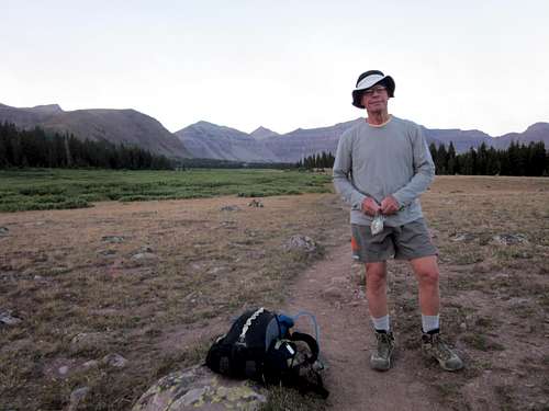
The ridge leading to Trail Rider Peak, our final 13er of the day, was not particularly steep but seemed never-ending. Many minor false summits caused us to turn first right and then left to re-adjust our way to the gently curved summit. Once there we luxuriated with a 20-minute break, a small victory celebration for knowing that we had topped the requisite peaks and now had only to descend to find Trail Rider pass and then follow the trail back to Gunsight Pass and then head for home.
Leaving the Kings-Emmons Ridge and heading for "home."
The initial grade of the east ridge leading down off the summit of Trail Rider Peak was steep and the boulders seemed more often precariously perched than on the main ridgelines up above. About half way down the 1,450’ drop the grade lessened but the boulders became smaller in size. It was a toss-up: either have nice big boulders with steep pitch or smaller less stable ones with gentler grades. Pick your poison. We knew one thing: if we never saw another boulder for two or three weeks it would be soon enough.
The trail we sought was plain as day, a light brown scar etched into the hardened soil and marked with a cairn befitting royalty. After wasting about 25 minutes because of a silly navigation error, we made a sharp left-hand turn and were soon descending on switchbacks down into the southern reaches of Painter Basin where we would, according to ZeeJay, find a nice clear stream from which to filter water. She was right, and we welcomed the diversion of filtering water before resuming our way toward Gunsight Pass, a small but discernible V about 3 miles to our north. Our watches told us that getting there before dark was now a foregone conclusion, and this made us shout for joy.
Before filtering water we purposely deviated from the trail to take a more direct tack toward Gunsight Pass, a bushwhacking exercise ZeeJay recommended. And it worked perfectly; we were able to easily avoid muddy sections, bogs and marshes, hopping on rocks across two more streams. We were making excellent time and my estimate of 7:30 for the pass soon became 7:00 and then was moved up to 6:30. At long last we saw humans, other hikers on a bona fide trail for crying out loud! Yup, that was the trail leading up to the pass, and it meant for us the end of bushwhacking and the beginning of familiar ground. We were parading northward and now each of the conquered peaks slumbered to our left, like stony planets stoically awaiting the next wave of alien visitors. A huge bank of cumulus clouds had formed fortuitously in the western sky, thus shielding us from the slowly setting afternoon sun.
The remainder of the hike was routine. We arrived at the pass before 6:30 and now knew that we would be fording Henrys Fork creek at Elkhorn Crossing in daylight or at least twilight. Our spirits rejuvenated by our earlier-than-hoped-for arrival at Gunsight Pass, we sped along the path we had last seen more than 12 hours before. We had been there with the rising sun and now we were there with the setting sun. Thus the sunrise and its counterpart were opposing but in a sense matching bookends to a successful day. Just beyond Dollar Lake we met a trio of ardent hikers, big hulking backpacks weighing them down, and they had the temerity to ask us if we had “summited Kings.” We laughed and told them they didn’t want to know what we had done. But upon their urging we told them, and they were jubilant, each of them insisting on high-fiving us before bidding us a fond farewell.
Our pace after Elkhorn Crossing slowed, darkness and fatigue exacting their toll. Now was not the time to stumble or turn an ankle. Thus we ended up returning to the trailhead register board just after eleven o’clock, signing in with muted enthusiasm and slogging to our quiet camping spot. The car was still there, the picnic tablecloth was still covering the south end of the table and the tent was upright. Life was good. And our trek, our saga, our journey was basically over. The good Lord had blessed us with safety and stamina. It felt somehow almost surreal to unshoulder our packs and put them away!
Strangely, neither of us felt hungry, so we cleaned up a tad and shoe-horned our tired bodies into the patient sleeping bags which had been waiting for nearly 21 hours. The waxing moon cast inky tree shadows across our campsite; it felt wonderful to assume a position 90 degrees away from vertical. Sleep came easily.
The following morning was scripted tightly and we played our roles like ardent members of the Screen Actors Guild. The motto of the morning was simply this: take it easy, clean up the camp site at our own leisurely pace and drive safely back to Salt Lake City. This we did. Can we recommend this trip for others? With hearty gusto we answer with a resounding, “You betcha!”
Our Stats - no world records here but plenty of satisfaction that we made it safely.
(These times are total elapsed times, not individual legs.)
Camping site to Alligator Lake trail split – 0+55
To Elkhorn Crossing – 2+06
To Dollar Lake camping area – 2+58
To Gunsight Pass – 4+13
To Kings Peak summit – 6+23
(The following times are for individual segments.)
Kings Peak to South Kings Peak – 0+53
South Kings Peak to 13,306 (disputed 13er) – 0+57
13,306 to Painter Peak – 0+32
Painter Peak to Trail Rider Peak – 0+48
Trail Rider Peak to intersection with Trail Rider Pass trail – 1+10
Trail Rider Pass to Gunsight Pass – 2+14
Gunsight Pass to camping site – 4+47
Total break/summit time – 1+45
Total time for round trip – 19+05
Comments
No comments posted yet.