
|
|
Area/Range |
|---|---|
|
|
40.75320°N / 110.3592°W |
|
|
13387 ft / 4080 m |
|
|
Overview
This is a spectacular and high ridge in the Uinta Mountains. The high ridge is 14 miles long and extends from Flat Top BM to Anderson Pass and using the same standards that are used for the Colorado 14’ers, this ridge route has no less than eight 13’ers. This is the highest continuous ridge in Utah, one of the highest in the United States, and certainly the highest in the United States outside Colorado.The peaks that will be covered on this page will be the ones between Flat Top BM and Kings Peak. On this section of the ridge, by using the 300 foot prominence rule, used to rank the Colorado 14ers, there are nine “ranked” 13’ers as well as two "un-ranked" ones. "South Emmons" is ranked on some list and has 270 feet of prominence.
The peaks are from north to south: Kings Peak, South Kings Peak, Peak 13,306 (un-ranked); Peak 13,387 (“Painter Peak”); Peak 13,247 (“Trail Rider Peak”); Peak 13,287 (“Roberts Peak”); Peak 13,068 (“North Emmons”); Mount Emmons; and Peak 13,170 ("South Emmons").
Peak 13,306 is listed on some peak list, but it lacks sufficient height above the saddle by most criteria.
Besides the 13ers, this ridge extends for several miles south over Peak 12,826 ("Owl Peak"), the Lost BM and Flat Top BM. Flat Top BM is a ranked 12er, while Owl Peak is ranked on some list.
This is a fantastic ridge run, but it is also very prone to thunderstorms and there are no low passes between the peaks. I have been to the ridge various times, and on one trip in August 1997, did the entire ridge run. Unfortunately, the normal afternoon thunderstorms thwarted my plans, and I dared not stand on the summits of Peaks 13,387 and 13,247, though I did complete the entire ridge. The two peaks mentioned remain the only 13’ers in Utah that I haven’t actually summited.
One thing that makes Utah's 13'ers different, then say the Colorado 14'ers, is that the distances from the nearest roads are usually much greater for the Utah 13'ers. Some of the peaks on this page are forty miles round trip from the nearest road!
The Uinta Mountains are one of the few mountain ranges in North America that run east to west rather than north to south. Within the Uinta Mountains are about 2000 lakes, and some 900-1000 are full of trout. Along with the San Juans in Colorado, the Uintas have more contiguous area above timberline than any other area in the Continental United States. This is a beautiful area with many lakes, meadows, wildflowers, and some rugged peaks. Solitude is usually easy to come by once you leave the popular fishing holes behind. Kings Peak is a very popular climb, but the rest of the peaks on this page see few ascents.
Utah's 12,000+ Foot Peaks With 200+ Feet Prominence
Utah's 12,000+ Foot Peaks With 300+ Feet Prominence
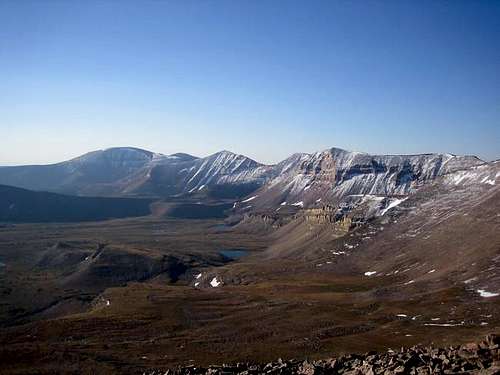
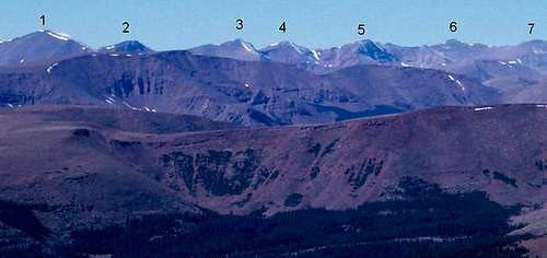 Kings-Emmons Ridge as viewed from the summit of Marsh Peak. September 30, 2005.
 The names of the peaks in the photo are below:
1 = Mount Emmons
2 = “North Emmons”
3 = “Roberts Peak”
4 = “Trail Rider Peak”
5 = “Painter Peak”
6 = South Kings Peak
7 = Kings Peak
Photo of Entire Ridge
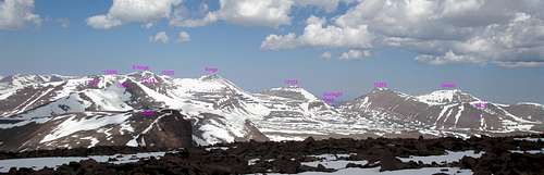
 Kings-Emmons Ridge as viewed from the east and the summit of Marsh Peak.
1 = Flat Top Benchmark
2 = “South Emmons”
3 = Mount Emmons
4 = “North Emmons”
5 = “Roberts Peak”
6 = “Trail Rider Peak”
7 = “Painter Peak”
8 = South Kings Peak
9 = Kings Peak
10 = “Henrys Fork Peak”
11 = Mount Powell
12 = “Gunsight Peak”
13 = Gilbert Peak
Names of Peaks
Like most peaks of the Uinta Mountains, even the higher ones, most of these peaks have no names. The names in the brackets are names I and others have given them for peak lists that have been created (dating back to 1990), and usually, simply the nearest named feature (i.e. lake, basin, or pass) to the peak was used tag the name on it, simply for the sake of the lists with so many un-named peaks.For years only one guidebook ever mentioned these peaks(Utah Mountaineering Guide; 1st, 2nd, and 3rd editions), and it referred to them briefly as simply the Kings-Emmons Ridge, so this is the only published name by which most of the peaks were ever referred to (South Emmons, for example, had a published name) until another guidebook came out a few years ago.
David Rose in his 2004 book lists different names for these and other peaks, but many people hesitate to use the names in his book since some of them attempted to change long-standing (and published) names of mountains that were known for decades (such as Henrys Fork Peak). Most of the individual mountain pages will probably mention the alternate names.
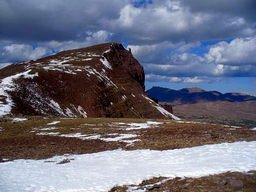 "North Emmons" is one of the several peaks on this ridge without official names.
Getting There
Uinta River Route:Note: These directions were updated as of November 2009 by SP member ZeeJay:
From the intersection of Highway 121 and Highway 40 in the town of Roosevelt in the Uinta Basin, drive west on 200 North (Highway 121). Stay on Highway 121 as it quickly bends to the north. Most junctions are marked with signs, but they are very hard to read in the dark. At mile 9.9, just after the actual mile marker 10 at a stop sign, at the hamlet of Neola go straight towards Uintah Canyon. At mile 16.7 continue straight. At mile 18, turn right to Uintah Canyon. At mile 21.9 turn right. At mile 22.2 turn left just after the bridge. Park at the trailhead at mile 25.6.
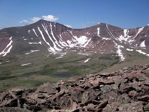 Roberts Peak and Trail Rider Peak from the east.
Swift Creek Route:
First drive to the town of Duchesne, which is along US Highway 40. From Duchene, turn north onto State Highway 87. Follow State Highway 87 until it joins with State Highway 134 (this is where state Highway 87 heads due east instead of continuing north) between milepost 15 and 16. Follow State Highway 134 north to the little town of Mountain Home. Where State Highway 134 begins to head due east at Mountain Home, Continue north on the Moon Lake Road. After five miles, turn east on the Yellowstone River Road and to the Yellowstone River Power Plant. Continue along the Yellowstone River road to the trailhead at the end of the road, passing the Yellowstone River Dude Ranch and two campgrounds along the way.
Dry Gulch Trailhead:
From the Yellowstone River Power Plant mentioned above, drive north along the Yellowstone River Road to the first major road heading east (right). With a map in hand, follow this gravel road east to Dry Gulch. From Dry Gulch, turn left and follow the road north through Dry Gulch to its end.
Routes Overview
The below is meant to be an overview only, so for more details, see the route pages.You could access this ridge from the North or South Slope of the Uinta Mountains, but access from the south is much easier and more practical. All routes will be described as a part of the ridge run and it is assumed that you will want to bag Kings, South Kings, and Emmons (and maybe even South Emmons) on the ridge run.
This is indeed a spectacular ridge run. Using the same standards that are used for the Colorado 14’ers, this ridge route has no less than eight 13’ers. This is the highest continuous ridge in Utah, one of the highest in the United States, and certainly the highest in the United States outside Colorado.
Briefly put, you will climb Kings Peak from the Uinta River, Dry Gulch, or Swift Creek and follow the ridge all the way to Mount Emmons, where you will descend either the Uinta River, Dry Gulch, or Swift Creek routes back to your vehicle. The routes usually take 4-6 days, assuming you have good weather. See the route pages for much more detail.
Uinta River Route
This is the easiest route to do the ridge run. From the trailhead, the route follows the trail north along the Uinta River to the Chain Lakes Trail and then to the Chain Lakes Basin. From there, there the route goes to Atwood Lake Basin, up to Kings Peak, and then south along all these peaks on this page and to Mount Emmons. From there, you descend Mount Emmons back to the Chain Lakes Basin and back to the trailhead.
 "Painter Peak" as viewed from the east.
Swift Creek Route
From the trailhead at the Swift Creek Campground, this route follows the trail north to Timothy Lakes. From there, it is recommended you take the highly scenic alternate route over Bluebell Pass, Milk Lake, and to Anderson Pass. This includes many miles of off-trail travel, but the going isn't that tough and the scenery is fantastic. The route then climbs Kings Peak, and then follows the ridge all the way back to Swift Creek and over all these peaks on the page to Mount Emmons.
 Kings-Emmons Ridge as viewed from Mount Emmons
Dry Gulch Route
This is the Granddaddy of all the ridge runs. If you like your physical medicine strong, and like complete solitude for days, then try this one. This route is very seldom used and the trails marked on the map bear no resemblance to reality. The area has several long faded trails and a few old logging roads, but no marked trails. To complicate things, sometime before 1997, a huge storm caused a blow-down of several of the trees around the area south and east of Bollie Lake, which obscured what old trails there were. The route description will be rather brief as you must be able to route-find on your own to follow the route. A GPS comes in very handy in the forest.
This route will visit Mount Emmons first (it is harder to find the route from above than below, so I would recommend Emmons first, which is the opposite direction of the rest of the ridge runs). From the trailhead the route goes to Heller Lake, and then route-find over into the drainage that is west of Jefferson Park. From there, you must go cross country to Bollie Lake. From there, the route climbs to Flat Top Benchmark (12,194 feet). Mount Emmons summit is reached in another 6 miles along the ridge. You will climb over several highpoints along the way. From Emmons, you climb over all these peaks on the page to Kings Peak. You can then return via this or another route. Consider this trip to be the “Uinta Mountains Ultimate Weight Loss Program”!!
Other Routes
There are still many other routes available. You could approach the area from the north and Henrys Fork or China Meadows, but this would be one seriously long hike if the entire ridge is traversed. From the south and east you could approach the area from the West Fork White Rocks area. Also from the south and west, you could go right up Yellowstone Creek. The only reason I have not added the route is because I consider it quite a bit less scenic than the Swift Creek route because you spend so many miles below timberline. Going up the bench west of Yellowstone Creek past Swasey Lakes and Five Point Lakes and to the Upper Yellowstone Basin is a very scenic route, but then you would need some sort of car shuttle after traversing the ridge all the way south to Mount Emmons.
There is one really scenic and nice alternative, but it would require a very long car shuttle. If you climbed Kings Peak from Henrys Fork on the north and then traversed the entire ridge south to Mount Emmons, you could exit by way of the Uinta River or Swift Creek Routes. This would be an awesome trip, but would require a car shuttle of several hundred miles since no roads cross the main core of the Uinta Mountains. You could have one group start on the south and one on the north and switch keys halfway between to make the car shuttle much easier, but this would take a lot of planning.
 Kings Emmons Ridge as viewed from West Gunsight. September 17, 2005
Red Tape
No permits are required. Normal wilderness rules apply.When To Climb
Mid-July through Mid-September is the normal hiking season. In winter the road is opened to within 4 miles of the Swift Creek Trailhead. This is the only practical way in for a winter climb.Interestingly, this ridge has been climbed in winter, at least from Kings Peak to Trailrider Peak/Peak 13,287. It was in December 1971/January 1972 by Mike Kelsey. Mike is a super-strong climber and did this and Gilbert Peak in six days. This is the only winter traverse I know of for the ridge, but if you know of any others, please post here. Most climbers will need much more time than six days to do the traverse in winter!! (Also interesting is that this winter trip was also the first known traverse of the ridge in any season).
 Kings Emmons Ridge in July.
Camping
There are campgrounds at both the Swift Creek and Uinta River Trailhead. No reservations are needed. There are also many informal campsites near Dry Gulch.There are many backcountry campsites along the trails. Some of the best ones for a are mentioned in the route desciptions.
Mountain Conditions
Click Here for Weather Forecast for Central Uinta MountainsHere are some average highs and lows from the 13,123 foot elevation (4000 meters) in the Uintas (about the same altitude as the summits):
| MONTH | HIGH | LOW |
| JAN | 11 | -4 |
| FEB | 13 | -2 |
| MAR | 16 | 1 |
| APR | 24 | 8 |
| MAY | 32 | 15 |
| JUN | 42 | 22 |
| JUL | 52 | 29 |
| AUG | 50 | 28 |
| SEP | 42 | 21 |
| OCT | 31 | 12 |
| NOV | 19 | 5 |
| DEC | 14 | 0 |