
|
|
Mountain/Rock |
|---|---|
|
|
36.77100°N / 118.55°W |
|
|
Hiking, Mountaineering, Trad Climbing |
|
|
Spring, Summer, Fall |
|
|
9146 ft / 2788 m |
|
|
Overview
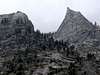
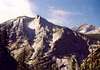
Located in Kings Canyon National Park, the Sphinx stands as a Sentinel, over 4000 vertical feet above the canyon floor. Situated at the very top of Kings Canyon the monolith overlooks the confluence of Bubbs Creek and the South Fork of the Kings River. It's not clear who came up with the name, but the formation appears on maps as the Sphinx, as far back as the early 1870's and no doubt the name was given because when viewed from the right angle, the two summited formation has a striking resemblence to it's Egyption namesake.The highpoint of the formation is the easily reached southern summit which forms the body of the Sphinx, the lower, north summit, is more difficult to reach and leans out over the canyon forming the head. The first recorded ascent of the lower summit is July 26th 1940 by Art Argiewicz abd Bob Jacobs. Their route is rated 5.2 (upgraded to 5.6 in the latest Secor guidebook)and climbs the "south side" after rapping to the notch from the southern summit. Only one other route is reported, according to the "Peaks Passes and Trails" (R.J. Secor), The North Buttress 5.7, climbs the north buttress of the north summit in two pitches.
 |  |  |  |
Getting There
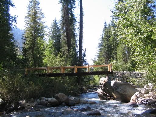
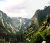
From Fresno take highway 180 east to Cedar Grove and continue another 6 miles to the trailhead at Roads End. From the parking lot, head up the Paradise Valley trail 2 miles of flat easy walking to Baily Bridge, where you cross over the bridge taking the Bubbs Creek trail. The next two miles head uphill swithbacking up a couple thousand feet. At the footbridge cross over, taking the Sphinx Creek trail a couple miles until you are south of peak 9,721', and head cross country to the rock or you can head directly uphill at the first opportunity where you can cross the creek, after the steep switchbacks (about a mile above the Sphinx creek bridge). In the spring the creek will be un-crossable, in which case you will have no choice but to stay with the Sphinx Creek trail until it crosses the creek.
Once at the notch, it's easy 3rd class to the last block, then it's just a couple of 3rd class moves to the top of the south summit.
Vertical gain is about 4700 feet from the trailhead to the top and about 6 miles each way.
 |  |  |  |  |
Red Tape
Admission to Sequoia Kings Canyon National Park requires a $20.00 per vehicle entrance fee, this fee will allow access for a period of 7 days. Other options available are the annual SEKI pass for $30.00 or the America the Beautiful Pass. These passes are available for purchase at Park entrance stations or online. For information click hereWilderness permits are required for overnight visitors. Available from the Roads end permit station, located at the trailhead and opens at about 7:00 am during the summer. Bearproof food canisters are required to get a permit and are available for rent at Roads end. Day hikers do not need a permit.
Permit info.
Bear info.
When To Climb
April through November. Kings Canyon is closed during winter.Camping
Lots of good backpacker campsites to choose from. The areas on either side of the Sphinx Creek bridge at Bubbs Creek are real nice and there is a NPS bear box on the west side of the bridge. Or you can find a spot closer to the rock, in fact there is a good campsite right at the notch of the Sphinx and peak 9721'.Also Car camping is available in the Cedar Grove area at four NPS campgrounds
Bob Burd - May 19, 2009 4:04 pm - Hasn't voted
North vs. SouthRob, You've mixed up the two summits. The South summit is the easier, highest one. The lower North summit is the tricky one. Also, Secor has updated the rating to 5.6 which seems to match more closely with the available TRs.
Rob - Jun 17, 2009 2:19 pm - Hasn't voted
Re: North vs. SouthThanks, I fixed it. Also changed the 4th to 3rd class for the higher summit, since I read in your TR, that you thought that's what it is, and your probably right! I'm gonna go back there again sometime to do the "Prow" and maybe some new stuff.
Noondueler - Jun 25, 2014 2:08 pm - Voted 10/10
I heard thatJohn Muir named it "The Sphinx".