
-
 5872 Hits
-
 73.06% Score
-
 3 Votes
|
|
Route |
|---|---|
|
|
46.36541°N / 12.55325°E |
|
|
Hiking, Scrambling |
|
|
Summer, Fall |
|
|
A long day |
|
|
Class 3 |
|
|
Hiking by marked paths, easy climbing (UIAA I) |
|
|
Overview
This is not only a route on Monte Pramaggiore, but a beautiful round tour which takes you first on a high panoramic summit and then over many notches and saddles through the most beautiful parts of the upper Val Cimoliana. The first four sections are exactly the same as on the route, which describes only the ascent on Monte Pramaggiore.
Rating The Tour (By Hiking Standards)
0. General. From 1163 m to 2479 m. Mostly comfortable paths, but also some steep and exposed passages. The summit ascent is an easy climb (loose slabs, covered with scree require a lot of attention), UIAA I. The whole round tour is well marked. Gear: Only good shoes and poles.
1. Effort. Cca. 1900 m, 11 h.
2. Power. 3 - medium (Only Monte Pramaggiore summit ascent: some pulling up while climbing UIAA I).
3. Psyche. 3 - medium (Only Monte Pramaggiore summit ascent: not very exposed, but a mistake likely fatal).
4. Orientation. 2 - easy (Only on summit ascent searching for best passages). The grading system for hiking and scrambling routes is here.
Getting There
See the main page how to get to Meluzzo (reachable by car).
Route Description
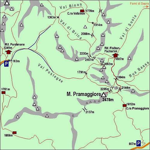 The upper Val Cimoliana area
In Val Postegae

In Val di Guerra
From Meluzzo, 1163 m, you continue by the main valley, cross the alpine meadow and pass Casera Meluzzo, after which the road starts to cross big sand fields, some kind of Cimoliana's Concordia. Going eastwards you reach the well marked crossroads and continue in the same direction into Val Postegae (No. 362 and 366). The cart-road goes by the creek in a SE direction. On the altitude of some 1280m the cart-road transforms into an ordinary marked path, which soon starts ascending through the forrest on the northern side of the valley. You quickly gain altitude, then cross a nice water stream and continue through the forrest in the eastern direction. Finally the path starts turning NE and you reach the beautiful alpine meadow, where ex Casera Val dell'Inferno stood. Towards the NE Val di Guerra lies and the path No. 362 goes through it on Passo del Mus. But that's not our goal. On the meadow we turn sharp right (good marked) and follow the marked path No. 366 towards Monte Pramaggiore. Below the vertical walls of Croda del Sion we comfortably go up the valley, the landscape is very beautiful and when we reach the last larch trees we can all the time enjoy the beautiful panorama towards the West. By a nice grassy ridge we approach the basin below Monte Pramaggiore, where the path goes towards the left and soon ascends Forcella La Sidon. This is the exit of a steep ravine, which comes from the north, and through which also the ferrata comes up. From there only a short crossing of (steep) slopes is needed and we reach Forcella Pramaggiore, 2295m. This is the key point where finally all approaches from valleys join and only the summit slope is awaiting you.

M. Pramaggiore summit

In Val dell'Inferno
From Forcella Pramaggiore you first follow a short ridge, but when it reaches the summit slopes, the path (still barely seen) turns a bit into the NE slope, away from the main NE ridge. Over slabs, crunchy steep terrain and some easy rocks you do some crossing and also a few turns up (you can follow marks), then you climb a few meters of more solid slabs and continue again towards the left by a similar unpleasant terrain. After some 20 meters marks direct you more directly upwards, the terrain is still loose and steep and you hardly wait to reach the main ridge. There some easy climbing (UIAA I) is needed to overcome rocky steps, but at least you can hold at something. The summit ridge soon brings you to the top of Monte Pramaggiore. 4 hours till here. By the ascent route you first carefully descend to Forcella Pramaggiore, where you turn right (eastwards) down over grassy slopes. Don't descend on the Pramaggiore alpine meadow, but after a steep descent over grassy slopes keep left (path No. 363) and cross to Forcella Rua Alta, 2144 m. Cross the saddle and continue by crossing steep scree slopes until the path reaches a distinct ledge, uses it to cross a steep rocky face and exits on the other side on a grassy ridge above Passo di Suola. Descend down on the pass, 1994 m.

Above Val di Suola
From Passo di Suola follow the comfortable path down towards Rif. Flaiban-Pacherini, but only to the altitude of some 1850 m. On the left you see great vertical walls, ending with the famous Torrione Comici. You need to cross the slopes just below the wall of Comici tower and reach a well seen path which goes from the hut on the notch behind the tower. If careful you will not lose altitude unnecessarilly, perhaps you will even be able to follow a weak trail. When reaching the path (it has No. 362) go by it up on Passo del Mus, 2063m. Some 7 hours till here. On the pass you will see the inscription that on Torrione Comici ferrata Cassiopea climbs. Do it only if you are ready for the hardest ferratas! It is said to require climbing around UIAA III-IV, so you need the set for ferratas.

Above Passo del Mus
From Passo del Mus you probably will not take the first chance to descend down in Val Cimoliana. You rather take the path No. 369, going further towards the NW. Across the slopes of Punta del Mus it ascends first on Forcella Fantulina Alta, 2107m, and a few minutes later on Forcella dell'Inferno, 2175 m. A great new view towards the North opens! Now we are standing on top of Val di Brica and we need first to descend into its upper part. Below the funny Mus di Brica, 2067 m, we cross towards the right and reach the next crossroads on good 1950 m. The recommendation is: Continue over the next pass into the next valley! So we keep right, cross the broad screes below the vertical walls of Cime Fantulina and Punte Fantulina and through dwarf-pines ascend the last saddle, Forcella Val di Brica, 2088 m. Again a wonderful new view opens - the broad green meadow of Canpuros surprises us.

Canpuros meadow
The path No. 369 takes us down on the meadow, where we shall certainly stop at a nice water source, winding over it. The place is dreamy beautiful, it looks that it is abandoned as a pasture. On the next crossroads we turn left, finally we must descend into the valley. Over meadows and a valley step we descend on the next meadow, where Rif. Casera Valbinon stands (1778 m). From there to the parking place the path No. 361 will take us. But it's still a long way to go.

Campanile Gambet
First the path leads us down through the forrest. When reaching the creek bed, we continue by it or just above it. The path is deteriorated and probably being a bit tired we need to take some additional care. The valley lowers only slowly. The next big crossing is on 1363m, where into the main valley two side valleys bring their paths. It's Val di Brica from the left and Val Monfalcon di Forni from the right. We continue down by the main valley. The path crosses a few water streams, gets occasionally completely lost, so we need to follow ciarns and rare marks. And there's still the 'Concordia' to cross. In this part of Val Cimoliana (Val Meluzzo) mountain creeks and avalanches brought down millions of tons of rocks and stones, so the path is really hard to maintain. Follow the ciarns. The path turns much towards the south, but you can cross the rocky plane also directly. Some searching of best passages is inevitable. So finally you reach the meadow of Meluzzo and the big parking place below Rif. Pordenone.