In the European Southern Alps despite progress there are still many areas of true wilderness. The one I'm describing in this overview is in the Western Julian Alps. Only a part of this group, again the western one is nowadays an unprecedented wilderness, where the tours are one or two degrees more demanding just because you are completely alone there and in some cases it's hours to the nearby at least fairly civilized point.
Unfortunately, I was not much visiting those areas. I only collected some published information, but gradings of tours difficulties are very subjective and far from standardized. Have in mind that almost only good experts are visiting those areas. So, what may be easy for them, may be already far beyond someone else's capabilities. Only for some routes I'm giving difficulty grades on the Swiss Hiking Scale (T1-T6). Click on map features to explore!
The Nature Of Mountains
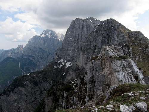
Jovet BlancMonte Cimone, Mucul and Ciuc di Vallisetta
The western part of Jof di Montasio / Montaž group is a distinct crest with some strong side crests and ridges. While Monte Cimone / Strma peč is reaching 2379 m, and the most desired summits are around 2000 m, the hamlets and small villages are all below 800 m of altitude. West of the broad Altipiano di Montasio, there are no bigger alpine meadows or pastures, some modest stables which were on the slopes 100 years ago have almost completely disappeared. It's now only dense forests, dwarf pines and bushes, very steep grassy slopes and wild ravines. And all that is on lower areas interrupred with wild crags and in upper areas with rocky crests and walls.
While on the southern side grassy slopes are reaching the summits and crests, the northern sides are even wilder. Even steeper, rocky all the way down to Dogna and on many places overgrown with dense dwarf pines. Only Monte Cimone is "open" for hikers, there are two bivouacs and three marked trails. Bivouacs are there due to the fact that such long tours can almost not be done in one day.
In The Past
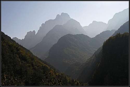
Cimone from Raccolana Valley
It's almost forgotten how some 100 of 150 years ago life in the valleys of Raccolana / Reklanica and Dogna / Dunja was. Yes, people were poor, very poor, on the edge of survival. Before migrating away, they were almost exclusively shepherds and (wild) hunters. From those times it's known that they had reached almost all the summits west of Monte Cimone / Strma peč and also Jof di Miez and Clap Blanc. The shepherds from Dogna found a very demanding passage for their sheep herds (Semide dei Agnei), which were led on the southern slopes of the crest.
Those people were climbing very exposed, short sections of up to todays UIAA III degree difficulty, but if possible, they were using natural passages - extremely steep grassy slopes, exposed ledges and wild ravines. With modern equipment, we have today only a little advantage in that terrain, perhaps only in belaying. They were of course not doing any harder climbing routes.
Getting There
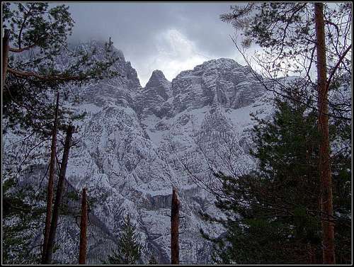
Montaz from Dogna
The valleys of Dogna and Raccolana are reachable from the Tarvisio - Udine highway.
In Dogna, no village or settlement is located in our mountain group. They are all on the other side of Dogna creek, but are serving as trail heads for here mentioned routes.
In Raccolana, there are some small villages just by the road, running through the valley on Sella Nevea, and two nice villages are higher on the S slopes of our group. Those are Patocco / Potok and Chiout Cali. Mountain roads to reach them are very narrow.
The third possible trail head is on the very eastern edge of our area. That's the big parking place on Pecol, reachable from Sella Nevea.
Trails In The Lower Areas
Before outlining the higher areas of our Wild West, lets just shortly mention some trails which can serve to get higher towards the pathless area around the summits:
In Dogna valley. While the road into Dogna runs across the northern slopes, across the southern slopes all the time above the creek Sentiero Umberto Pacifico runs (No 651). It's not some tourist trail at all. On some places it's demanding, can also be ruined by avalanches or landslides, but well marked and picturesque. From Dogna village in the valley mouth, till Sella Somdogna it's at least 5 h. From this trail two marked routes go up on Monte Cimone - see the SP page of that mountain.
In Raccolana valley. Across the S slopes of our group the so-called Via Alta (High Trail) runs. It connects the village of Patocco and the Altipiano of Montaž. The trail is very long, because it's winding a lot to go around many ravines and across many side ridges. The W part of it was much destroyed in 2013 by a forest fire, and it looks that one other part, near Rio Pilz, is still officially closed. So, again, no easy tourist trail, but a long, demanding traverse. You can also reach this trail from Chiout Cali village.
Easy Summits On The Very West
Monte Cimone, the highest summit, is also not particularly demanding (T3), see descriptions on its page. The other two are:
Monte Jama, 1168 m. To its panoramic meadow a quick and easy ascent (1 h 10 min) can be done from Patocco, but more fine is a round tour from Raccolana village.
Cuel de la Bareta, 1522 m. This very panoramic summit was heavily fortified during the World War 1. Today, the most reccommendable ascent (3 h) comes on it from Cadramazzo in Val di Ferro. The trail is very nice, but also very narrow and exposed. The trail from Patocco village is not much longer, but was destroyed by 2013 fire and is not well maintained, so it may be one degree more demanding.
High Summits West Of Monte Cimone
Monte Cimone, Mucul and Ciuc di Vallisetta
Two summits can be reached by some kind of steep trails or at least traces, marked by rare dots. Those are Cima Robinia, 1704 m, and Monte Jovet, 1814 m. The normal ascent on Cima Robinia goes by the ravine of Rio Livinale and then by the overgrown S slopes, on Monte Jovet traces go over its S slopes.
Jovet Blanc, 1939 m, is hard to reach. Those who attempt it, are reporting the route from the south. From Via Alta, they first go past the ex Stavoli dai Sbrici, then on Forca de la Puartate (notch) and towards the NW on the summit.
Ciuc di Valliesetta, 2089 m, is also very demanding. From Stavoli dai Sbrici explorers go over its steep southern slopes, then in the steep, grassy channel between it and the neighbouring Mucul, 2054 m, and finally on any of the two summits.
Jof di Goliz, 2182 m, can be reached in an easy climbing descent (UIAA I degree) from the E, from the summit of Monte Cimone. That can be less demanding than those steep grassy slopes of its W neighbours. The W crest (towards Mucul) is then much more difficult.
Just one more illustration - The misterious Semide dei Agnei passage: Shepherds of Dogna brought their sheep herds from the valley by all those rugged, steep slopes up till below Cima Robinia and Jof di Miezdi. It's hard to know where and how long it lasted, because today the trail from Patocco village around all those mountains and down to Dogna is closed and ruined. But from below Jof di Miezdi the only passage further was across the wild slopes above Sfonderat ravine. Hundreds of meters of abysses below and a passage of today's UIAA III had to be mastered - with lambs in the herd. Over the most difficult passage they probably had a small wooden bridge. Then the equally difficult slopes of Jovet Blanc had do be masterd, and they reached Forca de la Puartate, 1857 m. From there, they went on Pian de la Cjavile, the steep juicy meadows on the southern side of the crest. Every year twice that route was done.
Jof di Miez
Jof di Miez, 1974m.
That needle (1974 m) stands just before the huge western face of Jof di Montasio / Montaž, that's why it was much neglected. Reached first by hunters, then by Julius Kugy it's today one of the most difficult summits in the area. From Sentiero Umberto Pacifico the normal ascent route goes till the end of Rio Saline, where you must choose the proper ledge up (they say, the middle of three) - crumbly, steep, exposed. Above animal traces can bring you on the sumiit ridge and the highest point. If all goes well, the difficulties don't exceed UIAA II degree, but the tour is very long. The neighbouring Clap Blanc, 1657 m, is only a bit more easy, but of no value for Jof di Miez ascent.
Clapadorie and Rio Saline
Clapadorie gorgeAmazingly wild place,...
The first gorge, actually a deep, wild canyon, is the wildest ravine in the whole Julian Alps. Long, with steep, wild, up to 300 m tall walls, practically impassable. Actually, the summit of Montaž is just above it, but more than 1500 m higher - it rises from Dogna valley end almost 2000 m. Today nobody climbs there. It was climbed by details, other sections were detoured. Mira Marko Debelak, one of the best Slovenian feminine climbers, descended with her partner from Forca dei Disteis and the adventure (described in Alpine Journal) lasted a whole day.
Riop Saline is only a little less wild and between the two gorges there's the crest of most impossible limestone needled - Curtissons, Cresta di Lance. It is assumed that until now only one insane party climbed it - the tour was graded UIAA V - and later nobody else challenged those extreme, friable butchers knives.
Parents refers to a larger category under which an object falls. For example, theAconcagua mountain page has the 'Aconcagua Group' and the 'Seven Summits' asparents and is a parent itself to many routes, photos, and Trip Reports.

 1856 Hits
 78.27% Score
 9 Votes