
-
 12840 Hits
-
 73.06% Score
-
 3 Votes
|
|
Route |
|---|---|
|
|
40.69730°N / 121.5802°W |
|
|
Hiking, Scrambling |
|
|
Summer, Fall |
|
|
Overview
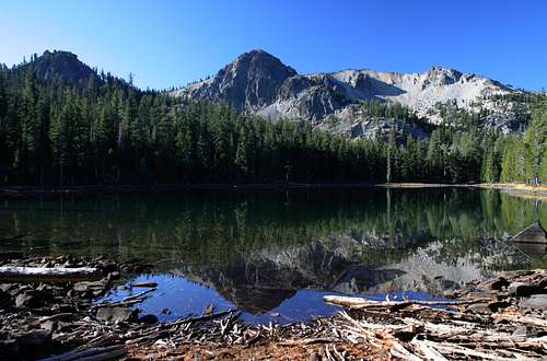
 Crater Peak seen from Everett Lake
Although relatively small compared to most California wilderness areas, the Thousand Lakes Wilderness compresses an abundant number of excellent features into its compact area. High peaks reaching above the tree line, rugged cliffs, gorgeous glacial lakes, cinder cones, and old growth forests are all highlights of this seldom-visited area. The Thousand Lakes Valley Trail has two distinct components. The first is the loop that circles the heart of the Thousand Lakes Valley. The second part is long spur that departs the loop climb up to the Crater Peak rim. The loop and spur are doable in a single trip that manages to collect many of these elements into one splendid journey as one travels from dense forests, through a lake field glacial valley and the massive remnants of a volcanic crater to the extinct volcano’s rim, where one is treated to spectacular views of northern California. To top it off, this route provides access to three peaks exceeding 8,000 feet.
The spur to the crater rim and the loop can be done in either order. This can be determined by preference or by convenience according to which trailhead is used. Both the Cypress and Tamrack trailheads make convenient entry points for the Thousand Lakes Trail. The Cypress is closer to the spur while the Tamarack is closer to Eiler Lake, the premier destination on the loop. For the purposes of this page, the trip from Cypress to the spur, followed by the loop in returning to the Cypress trailhead.
Route Description
 Red Cliffs seen from Everett Lake
The trail from Cypress trailhead to the crater rim is 6 miles long and climbs 3,500 feet. From the trailhead, the route quickly crosses the normally dry Eilier Gulch. Once across the dry creek bed the trail swings south and begins to climb the eastside of the gulch. The grade is moderately steep but is not difficult and the trail is well maintained. After 1.5 miles the trail reaches a junction. Proceed to the right. If one stays to the left, large Eiler Lake is reached in 0.75 miles, and the base of Eiler Butte is another 1.0 mile further. The junction also serves as the beginning of the off-trail route to the summit of 7,845 foot Freaner Peak. This peak is a large shield volcano and has excellent views into the interior of the Thousand Lakes crater from its summit.
Proceeding from the junction, the trail continues through the forest and reaches another junction in 0.3 miles. Continue to the right. A third junction is reached another 0.25 miles further. Again, continue to the right. Shortly after the third junction, the trail begins to switchback up a glacial moraine. After a little less than 0.5 miles the trail levels off and straightens out. The trees thin significantly and the crater rim begins to come into view. Although it has straightened out, the trail continues to climb at a steady but reasonable grade. A mile from the top of the swithbacks the route passes the Upper Twin Lakes. These small pools may dry up late in a dry year, but are generally the first water along the route. The Red Cliffs are prominently in view at this point and another 0.25 miles past the small lakes, the trail reaches Everett Lake. Here the Red Cliffs loom ominously above the lake. Although Magee Lake, which lies 0.25 miles further up the trail is just as attractive as Everett Lake, the north shore of Everett provides what may be the best campsite in the Thousand Lakes Wilderness. Watching the sunrise on the towers beyond the lake is quite memorable.
 Looking north toward Mt. Shasta from the crater rim
Although a trail continues along the shoreline of Magee Lake, the junction with the route to the crater rim is located at the north end of the lake. The sign has been knocked down so it may prove difficult to spot. If one reaches the end of the lake, one can either backtrack and find the junction or head due west from the lake, crossing a small drainage. This trajectory will eventually intersect with the main trail.
From Magee Lake the trail continues to climb steadily. Although there are sporadic groves of trees, the path is generally open and views of the Red Cliffs and the crater are excellent. After 0.75 miles the trail enters into the crater, but since the breach in the crater wall is nearly 0.25 miles wide, the passage into the crater is not as dramatic as one might expect. Nonetheless, the views from the interior of the crater are excellent. One can observe Crater Peak, Magee Peak and the Red Cliffs. Another 0.5 miles further into the crater, the trail beings its final ascent, swithcbacking steeply up the southern wall of the rim.
Once the rim is achieved, it is only a short distance further to the junction with the Magee trail. From here, the views are spectacular, taking in most of the California Cascades, including Mt. Shasta and Lassen Peak. The Trinity Alps, the North Coast Range and the distant Warner Mountains are also visible. From the junction, one can follow the rim eastward to the summit of the Red Cliffs or to the north, climbing Magee and Crater Peaks.
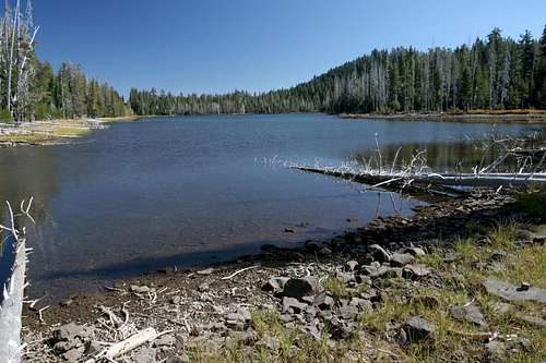
 Thousand Lakes high peaks from Barret Lake
When time to return, depart the crater rim, pass Everett and Magee Lakes and descend the switchbacks at the beginning of the spur trail. Once done with the switchbacks and back at the junction, turn right, rather than returning to the Cypress trailhead. About 0.25 miles from the junction, another junction is reached after crossing Eiler Gulch for the last time. To the left the trail returns to the Cypress trailhead again. Continuing straight will lead directly to Eiler Lake and a shorter and less interesting variation of the loop. Instead, turn right and continue on the main loop of the Thousand Lakes Trail. It is another 0.75 mildly descending miles to Barrett Lake, passing a small pond en route. The lake has descent views of the Red Cliffs. Another mile beyond Barrett Lake, the trail finally reaches another trail junction, this time with the trail coming from the Tamrack trailhead. This is where one would begin the loop if utilizing that trailhead.
The junction with the Tamarack trail is right at the base of Eiler Butte, amongst a collection of unnamed lakes. If one desires to climb the butte,this is not the place to do it. Turn left at the junction and skirt the base of Eiler Butte for 0.5 miles, passing a few more unnamed lakes. Finally, still skirting the base of Eiler Butte, the trail reaches Eiler Lake, the largest in the Thousand Lakes Wilderness. This is the point where an ascent of Eiler Butte is most feasible. Simply head up the side of the butte through the forested area. There are also numerous campsites in this area.
 Looking back toward Eiler Butte from the west end of Eiler Lake
From the junction at Eiler Lake, the trail continues along the lake's south shore for 1 mile. At 0.9 miles, at the west end of the lake, there is yet another junction. This one comes from the shortcut from the spur. Stay straight along the lake shore for another 0.1 miles before leaving the lake behind. Proceed another 0.8 miles to the junction with the Cypress trail, thus completing the loop. This section of trail passes broken up lava flows that flank the base of Freaner Peak, which overshadows this whole area.
Map
 Thousand Lakes Valley Trail
Getting There
 Much of the trial passes through the territory seen from Eiler Butte
 Cypress Trailhead
From Highway 89 just north of the Forest Service's Hat Creek Work Station, head west on Forest Road 34N19, which is also road 26. Once on the road climb to the south and then it will cross a ridge and head west. At approximately 8 miles, turn left on Forest Road 34N60. Proceed to the road's end at the trailhead. The road is signed to the trailhead.
Tamarack Trailhead
On Highway 89 south of the Honn Campground, head west on Forest Road 34N25. This road climbs up a few switchbacks before leveling off and heading south. After approximately 5.5 miles, turn west on Forest Road 34N25L. Proceed a short distance to the trialhead. The road is signed to the trailhead.