Overview
When Seattle-area climbers say they are going to “climb Tiger Mountain”, they typically mean a hike up West Tiger 3 (2557 elevation), which has a half-dozen heavily used trails to the top from trailheads along I-90 and in Issaquah. It’s a bit of a surprise that, with over 1600 SPers in Washington state, no one has bothered to document Tiger here before; probably because Tiger sometimes seems more like a city park than a mountain, and is really just a hike. Nevertheless, Tiger is probably the most heavily used 2000 vertical feet of hiking in the state, being a favorite conditioning hike for Seattle metropolitan area climbers. Tiger Mountain is a ridge located in the western the foothills of the Washington Cascades, just east of Seattle. Tiger’s main ridge runs WNW/ESE about 6 miles, with summits being (from east to west) Tiger Mountain (3004), West Tiger 1 (2948), West Tiger 2 (2757) and West Tiger 3, (2557). There are two summits to the south of the main ridge, Middle Tiger (2607) and South Tiger (2028).Tiger Mountain is bounded by I-90 on the north, Washington State Highway 18 on the southeast, Issaquah Hobart Road on the southwest, and the city of Issaquah on the west. The land is administered as the
Tiger Mountain State Forest by the Washington State Department of Natural Resources (DNR).
Getting There
![North Side of West Tiger from Tradition Lake]() West Tiger Mountain from north side of Tradition Lake (powerline easement)
West Tiger Mountain from north side of Tradition Lake (powerline easement)The main parking area for Tiger Mountain is the Highpoint Trailhead, located near the Highpoint Way exit (Exit 20) of I-90, just east of Issaquah. Make a 180 degree right turn from the eastbound exit onto a frontage road that ends at the paved trailhead parking lot in a high-tension powerline easement. This 80-100 car parking lot was developed in the late-1980s/early-1990s, improved in the summer of 2007, and subsequently fully paved. It is typically overflowing on weekend mornings. The portion of the road prior to the gate is used for parking both by those who do not have the Discover Pass as well as those going up the Cable Line route or trails further east on the mountain. You may also see cars parked nearer the I-90 interchange, for hikers accessing the High Point Ridge trail. There is a signboard at the parking lot trailhead with a trail map.There are several other trailheads. One is located just south of Issaquah High School, and another near the highway maintenance yard near Preston (west of Exit 22 on another frontage road). The trailhead just off Highway 18 at the east end of the mountain is used mostly by
mountain bikers using the east portion of the mountain. This is actually the closest and quickest trailhead to Tiger Mountain proper. The
Poopoo Point hang gliding and paragliding launch spot is located at the west end of the mountain, and is accessed by roads from the southwest.
West Tiger 3 Trail Network
![Trail Map 0807]() West Tiger 3 Trails, including new (spring 2007)main trail alignment
West Tiger 3 Trails, including new (spring 2007)main trail alignment There is an extensive network of formal and informal trails on Tiger Mountain. Some of these follow old logging roads and old logging railroad grades (an information sign east of the educational shelter near the parking lot claims the Tiger Mountain cog railroad was one of the steepest in the country when in operation in the first half of the 20th Century). The three most heavily used trails from the trailhead (520') to the West Tiger 3 summit (2557') are the main West Tiger 3 Trail (WT3), the Cable Line, and the Nook/Section Line Trail.The most popular of these is the
West Tiger 3 Trail(WT3) to summit. This is the green line on the accompanying map. Although signed as 3 miles, it may be somewhat less than 3 miles. The WT3 trail is well-signed at all intersections. Follow signs from the parking area. In a couple hundred yards the graded path turns sharply west (to become the Bus Trail, which loops around Tradition Lake and passes the remains of an old bus), but the WT3 trail continues straight (south) at this point and continues past another junction that heads east (a return loop of a much longer hike, the full Tiger Mountain Trail). The WT3 trail follows an old logging road up. At 1200 ft elevation is another junction. Continuing straight at this point traverses about 1/2 mile to the talus “caves”, the WT3 trail turns left up the mountain. Just before point 1323 the WT3 trail turns right and follows a new (spring 2007) track beginning at a junction/switchback. Bearing left at this junction gets you to the Cable Line trail in 50 yards. The DNR has shut off use of the loops of the old trail east of the Cable Line. Higher up, at 2000 ft elevation the Railroad Grade can also be used to switch between the main trail and the Cable Line. Above the Railroad Grade, the new WT3 Trail mostly follows the old track, but it was re-graded and improved up to nearly the point where the trail crosses the Cable Line, just a few hundred yards below the summit. The trail continues southeast from the summit of West Tiger 3, crossing trails to the east and southwest side of the mountain, and reaching the end of the road network near the summit of West Tiger 2 in less than 1/2 mile. The view from West Tiger 3 disappeared behind the growing forest in the 2000-2010 period, but the summit area of the entire mountain (ownership retained by Weyerhaeuser) was logged in 2021, and the views returned. Trails through the clearcut have been re-established. You can still see Seattle and views of Mounts Rainier and St. Helens to the south have been restored. The panoramic photo here was taken in the 1990s.
![Tiger Mountain Panorama to West]() Panorama from point south of West Tiger 3 summit - clearer picture, when available, will show Olympic Mountains.
Panorama from point south of West Tiger 3 summit - clearer picture, when available, will show Olympic Mountains.Two trails used extensively by climbers visiting Tiger for training are the
Cable Line Trail and the
Nook / Section Line Trail, which are just to the east and west respectively of the main WT3 trail. The
Cable Line Trail literally follows the track of a buried cable laid in the 1960s, and paralleled by a second line in the 1980s, to provide power to communications towers on West Tiger. A bundle of these cables were torn up by a windfall in 2002, near 2000' elevation just after the crossing the old WT3 trail. The Cable Line Trail is marked as the red dashed line on the accompanying map. It was mostly overgrown by the early 1990s, but as more and more Seattle-area climbers started using Tiger in the evenings during the week for training, the Cable Line became more of an informal, unofficial trail. An old road just 50 yards east of the gates accesses the start to the Cable Line Trail at the high tension power line crossing. Look for the big boulders blocking the old roadway. From the power line easement, the trail goes essentially straight up to the West Tiger 3 summit, climbing the 2000 vertical feet 1.5 miles. Its a great workout! A number of years ago the DNR considered closing the Cable Line Trail to hiking due to casual hikers finding their way onto it by mistake, as it used to coincide with and cross the WT3 Trail at several points on its way to the summit. Climbers eager to retain the trail/non-trail as a workout resource convinced the DNR that signage warning the unwary were sufficient to keep the way open for those using Tiger for conditioning, and the new WT3 minimizes the opportunity to get onto the Cable Line accidentally. More recently the signs were toted to the near the summit of WT3.
The other frequently used conditioning hike to the WT3 summit is the
Nook/Section Line Trail, which is to the west of the main trail. This is the blue line on the accompanying map. To get to the beginning of the Nook Trail, bear right on the graded trail where is splits from the WT3 trail just south of the trailhead. This section is signed "Bus Trail", named for the old bus several hundred yards further to the west. About a hundred yards after leaving the WT3 junction (and well before reaching the bus!), just past a small bridge, the well-signed Nook Trail starts up through the forest, gently at first, then traversing west (right) at a "Y" with the connector trail past the Talus Rocks over to WT3. The traverse intersects with the Section Line Trail (actually an old logging road) that switches back east (at this point it is signed as an "Unmaintained Trail"), bends west past the turn-around end of the old logging road, and soon starts climbing at a more determined angle more or less straight up the mountain. Although not as short as the Cable Line Trail, the Nook/Section Line Trail still reaches the summit in less than 1-3/4 miles, and generally provides a bit more terrain variety and better footing than the Cable Line. It is more of a trail, whereas the Cable Line is little more than a scar!The
Tiger Mountain Trail (or TMT) is a longer way to get to West Tiger 2 and 3. The trail traverses to the east for about 2.5 miles before heading up to the Railroad Grade. The portion of the TMT east of High Point Creek actually descends, so you get more elevation gain than the more direct routes. Note that as of the storms of January 2009 the eastern loop of the TMT requires crossing a severely damaged bridge that is nominally "closed" crossing the east fork of the creek, and higher up a substantial washout of the section on the Railroad Grade just west of the east fork bridge that requires some bushwhacking on unstable ground to pass. A way-trail is developing around the latter obstacle, but it is currently fairly difficult terrain by Tiger Mountain trail standards. The TMT attains the main ridge of the mountain between Tiger 2 and Tiger 3, and then continues southeastward roughly across the top of the main ridge.A TMT alternative that cuts off several miles and avoids the above-mentioned current disruptions is what I always referred to as the
High Point Ridge Trail. For a long time this was an unofficial trail that comes down a beautiful ridge from the Railroad Grade, and is shown on the map as a dashed line. Since it was infrequently used, the ferns caressed your thighs along the upper portion, and in several spots it was somewhat difficult to follow. All that will now change. It is evidently sanctioned, and is referred to as the
K3 Trail on new trail signs and the Green Trails map.We will eventual add trail descriptions the longer
High School/Section Line and
Poo Poo Point Trails.
Red Tape
Tiger is administered as the 14,000 acre Tiger Mountain State Forest by the Washington State Department of Natural Resources (DNR) and adjoining City of Issaquah land. The West Tiger Mountain/Tradition Plateau Natural Resources Conservation Area (NRCA) encompasses the northwesterly 4,500 acres of the mountain. The balance is State Forest Trust Land, administered for the benefit of schools, counties, and local services through timber and communication tower revenue. The Washington State Discover Pass is required for parking beyond the gate for the Tradition Plateau/West Tiger Mountain Trailhead. This gate which is closed at dusk (sometime not -- this seems to be less strictly adhered to recently). This may or may not be a problem for late evening hikers. Most such folks park on the pavement if they are hiking in the evening, but if you are caught after dark and find the gate closed, check it out closely because in the past it has not actually been locked, so you MAY be able to get out! Now and then the person who unlocks the gate oversleeps, so some mornings the gate may not be opened until 8:30a.m. or so, although usually it is unlocked well before then.PLEASE NOTE THAT THE FRONTAGE ROAD, ALTHOUGH USED EXTENSIVELY FOR PARKING, IS A HIGH CAR PROWL AREA. There have been several serious incidents of car break-ins in the past, even during broad daylight. PLEASE DO NOT LEAVE VALUABLES IN YOUR CAR, as this is what makes trailhead crime worthwhile for those low-lifes who engage in such larceny.
Camping
CAMPING IS NOT ALLOWED IN THE TIGER MOUNTAIN STATE FOREST. CAMPFIRES ARE ALSO PROHIBITED.
What About the Cave(s)?
The USGS identifies a "Cave" at around 1200 ft near the west end of the Talus Rocks cross-over trail. The cross-over and the Nook Trail was, at one time, referred to by some as the Cave Trail. The large talus rocks in this area do have some nooks under the up-hill side, but by most measures no one would call them a "cave", and would-be spelunkers will be sorely disappointed. The trail junctions off the WT3 and the Nook Trails are both well-marked, and this makes a good loop hike for those looking for a shorter sub-wilderness hike than going all the way to the summit.
Links
Issaquah Alps Trail Club is a volunteer organization that acts as custodian of the trails and mountaintops of the Issaquah Alps, consisting of Tiger, Cougar, and Squak Mountains near Issaquah, as well as Taylor Mountain, Rattlesnake Ridge, and Grand Ridge. The "alps" were named as such by Harvey Manning.
Washington Trails Association - During the winter and spring there are frequently trail condition reports posted here for Tiger.
Wikipedia Photomap of Tiger Mountain Tigers in Washington?
Perhaps it was named for someone named "Tiger", but it seems evident that the name derives from the fact that "Cougar Mountain" already had that name and "wild cat", "puma", "mountain lion" and "bob cat" weren't nearly as romantic sounding. Cougars are occasionally seen on Tiger Mountain. The last reported
cougar shooting was in 1999, but sightings are reported nearly every year, and occasionally warnings are posted at the trailhead. Wildlife on Tiger is reasonably abundant. I've seen deer, raccoons, squirrels, chipmunks, owls (a nice Great Grey Owl recently), frogs, lizards, and seen or heard many types of birds. Certainly the woods are full of others -- bears are occassionally sighted.Flora is also abundant and varied. My favorites are the trillium, which appear in spring, and on some of the lesser used trails I enjoy the ferns caressing my calves. The mountain is not without the obvious signs of the impact of man, but it is a well-loved forest resource, as testified by the cleanliness of the trails in spite of being practically-speaking a metro-area park.

 West Tiger Mountain from north side of Tradition Lake (powerline easement)
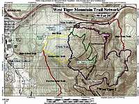 West Tiger 3 Trails, including new (spring 2007)main trail alignment
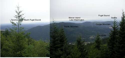 Panorama from point south of West Tiger 3 summit - clearer picture, when available, will show Olympic Mountains.