
-
 26375 Hits
-
 80.49% Score
-
 12 Votes
|
|
Route |
|---|---|
|
|
45.84420°N / 6.90754°E |
|
|
Ice Climbing |
|
|
Spring, Summer |
|
|
Most of a day |
|
|
D |
|
|
Overview
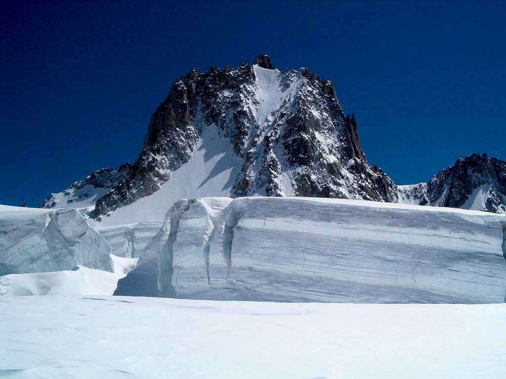
Tour Ronde North face
The Tour Ronde 3792 m is a snow-capped mountain located on the Italy-France border in the Mont Blanc massif. The summit offers a truly magnificent panorama on the majestic peaks in the surroundings, as the Monte Bianco with the Brenva wall, Mont Maudit, Mont Blanc du Tacul, the granite peak overlooking the Valleé Blanche, the Dent du Geant with Rochefort and the Grandes Jorasses and many others.
It is a very popular peak along the Normal route and the ice climbs, in reason of its highly panoramic position and speed of access. The routes can be climbed starting early in the morning from Courmayeur with the first ascent of the Entrèves - La Palud cable car, but the overnight stay at the Refuge Torino is recommended for optimal acclimatization
Getting there
The Tour Ronde is conveniently reachable from Courmayeur on the italian side of the massif. For a correct acclimatization is advisable to stay overnight at the shelter, the Rifugio Torino. Also possible climb this route starting from the Refuge des Cosmiques on the French side, but it involves a far more longer approach.
Getting to Courmayeur
- From Turin and Milan: follow the A5-E25 Motorway and exit Courmayeur, reaching the hamlet of La Palud m. 1370 - From France: through the Tunnel of Monte Bianco - From Switzerland: through the Great St.Bernard Tunnel or the Great St.Bernard Col or via Chamonix and Tunnel of Monte Bianco
From Courmayeur to Rifugio Torino
From Entrèves - La Palud take the cable-car leading directly to Rifugio Torino (exit second station, the first one is the middle Pavillion station, the third one is Punta Helbronner). Info: Funivie del Monte Bianco
Approach
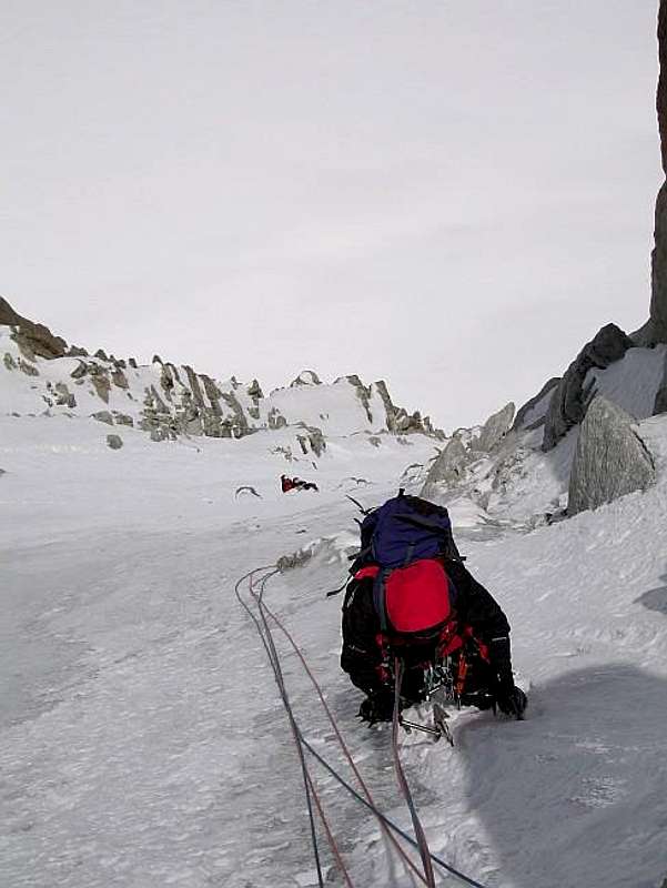
From the Rifugio Torino head NW towards the impressive Glacier du Gèant crossing the Col des Flambeaux 3407 m. From here you descend following an obvious track passing under the Col de Toule and always traversing in the W direction to the mouth of the Combe Maudit located just below the North Wall, characterized by a wide end crevasse.
Generally the track is very obvious, be careful, after the Col des Flambeux, not to head in the S direction towards the Col d'Entrèves 3517 m where it starts the Normal route.
Route Description
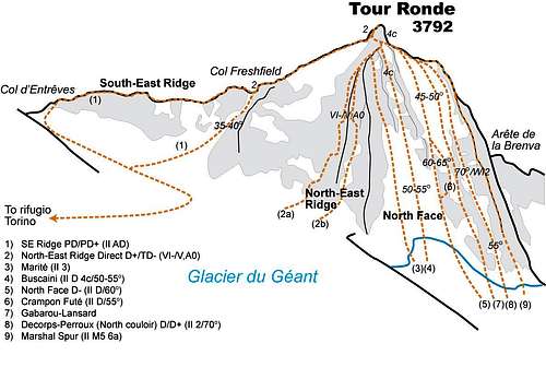 Tour Ronde topo. Drawn by Ari...
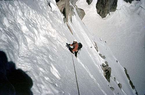
The North Face classic route (Gonella-Berthod) runs in the middle of the wall and it's about 400 m high (10 to 12 pitches) with ice continuously up to 60° with an average of 52°. In the middle the face narrows to an icy couloir and then opens again for the upper slopes. It is here that it steepens up to 60°. It is best to stay at the right side close to the rocks to get good belays. The summit (Statue of the Madonna with the summit book) can be gained by climbing directly to the top (on rock, IV, 30 m) or going left of the rocks and joining the Normal route on the South-East ridge.
The wall can be divided into three different and easily identifiable sections:
Part I - After the bergschrund (one of the most difficult stretches of the climb), climb for about 120 meters with a slope of about 50 °, heading towards the base of the gully clearly visible on the right. It is possible to protect yourself by using spikes with lanyards on the right of the ascent line;
Part II - the Canalino. At the entrance to the bottleneck there is a stop beyond which there is often live ice for about 150 meters with a slope of about 60 ° and mixed sections.
Part III - You are exactly on the vertical of the crest where the Gervasutti Canal ends, climb up the uniform slope, without moving too much to the right or to the left, for about 150 meters with a slope of 55°.
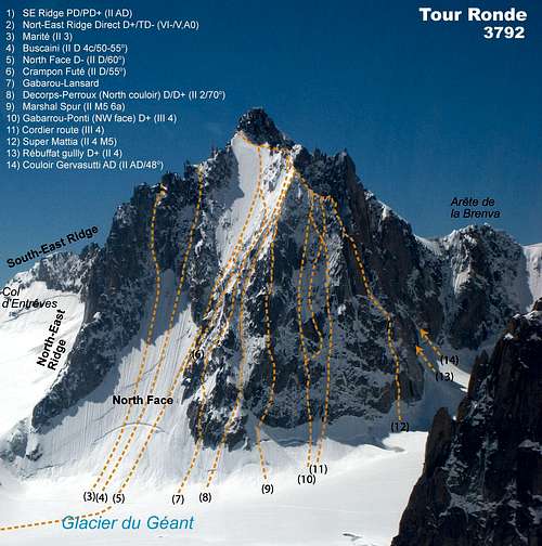
Other routes on the North-Face are:
1- Voie Buscaini D (II) Length: 350 m - First ascent: Gino Buscaini, 19.8.1959
2- Crampon Futé D (II) Length: 350 m
3- Gabarrou-Ponti W2, 70° Length: 350 m - First ascent: Patrick Gabarrou and René Ponti 25.6.1978
4- Couloir Decors-Perroux II, 2 Length: 350 m - First ascent: P. Decorps and G. Perroux, 1.12.1978
Descent: the descent along the Normal route on the South-East ridge is rather long. See here the report on SP: South-East Ridge (normal route) Easier and faster, there are other two possibilities: the descent on the adjacent East slope or the descent on the steep but short gully that descends from the Col Freshfield (see up the topo). Both are generally to be preferred if in good condition (only with low temperatures and good snow), otherwise it is better to follow the Normal route on the ridge
Essential Gear
Crampons, 2 ice axes, rope,several ice-screws and other safety equipement
Red Tape
No fees and no permit required
Hut
- Rifugio Torino m. 3375 – C.A.I. Sez. di Torino
Camping
Several comfortable camping places in Val Veny and Val Ferret
When to climb
The best season is spring and early summer.
Meteo
Meteo Regione Valle d'Aosta
Meteo Chamonix
Meteo Chamonix
Guidebooks and maps
"La chaine du Mont Blanc" Guide Vallot n. 1 route n 125
"Neige, glace et mixte Le topo du massif du Mont-Blanc: Tome 2, De l'Envers des Aiguilles au bassin de Tré-la-Tête", François Damilano, JM Editions, 2006
"Mont Blanc Massif" vol I - Griffin Lindsay, Alpine Club 1996 ISBN: 0-900523-57-3
- Maps - Meridiani Montagne “ Monte Bianco” map 1:30.000 - Swiss Topo 292 Courmayeur
sbumbolo - Jun 5, 2006 1:18 pm - Hasn't voted
Interesting Route's detailsI did it with Bruno Arrigo and alpine guide Corrado Gonthier on June 2nd 2006. Because of the snowy conditions, we did the approach skiing from Rif. Torino and climbed with ski touring shoes. Overall duration : 5h Rif. to Rif. We’d make the first belay (sling on rock) just before the icy couloir and the second just after the icy couloir (you’ll find two nails on your right at the exit of the couloir. Aniway don’t trust too much on these two nails). Once in the couloir, we’d kept the right side because the ice was better. Corrado put one ice-screw in the couloir (with Tbloc) and slings on rocks with Tbloc on the upper slopes (eg : two for the crossing at the end of the upper slopes).
paulbracey - Aug 3, 2014 8:50 am - Voted 9/10
Awesome Route!We climbed this route the last week of June, 2014, hiking in from the Torino hut. We found that a couple of pickets were handy and made the passage through the bergschrund a bit safer with all that rotten snow to get up through. The pickets didn't get used after that, but ice screws were handy. The climbing was never difficult, but it is a pretty long way up - 8 pitches (if we counted them correctly) - and fairly exhausting. It is a good idea to familiarize yourself with the descent route (the normal route on the East Face) as it is not readily apparent and may take some poking around to be sure you're going to end up where you expect. It really is a spectacular climb. Highly recommended! Cheers!