
|
|
Trailhead |
|---|---|
|
|
40.47564°N / 105.46056°W |
|
|
Larimer |
|
|
Summer |
|
|
7800 ft / 2377 m |
Overview

Trailhead & Parking lot
This trailhead, located in the Roosevelt National Forest, provides access to the NE portion of RMNP and sections of the Comanche Peak wilderness. Two trails begin here. The Bulwark Ridge Trail, which skirts the Comanche Peak Wilderness as it heads NNW toward Signal Mountain and the South Fork of the Cache La Poudre. The North Fork Trail follows the NF of the Big Thompson to it’s headwaters near Hagues Peak and Icefield Pass in Rocky Mtn Nat Park. Another trail, the Stormy Peaks Pass Trail splits off to the north from the NF Trail 7.4 miles from the TH. Most destinations accessed by this trailhead require approaches of 10 miles or more.
Trailhead facilities - Large dirt parking lot/ pit toilet/ no water.
Directions
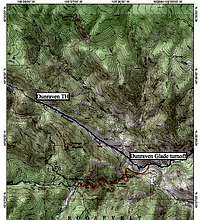
Trailhead Map
From Glen Haven - 2.1 miles east on Larimer County Road 43 then left onto Dunraven Glade Rd.
From Hwy 34 at Drake - North on Larimer County Rd 43, 6.1 miles, then right onto the Dunraven Glade Rd.

Dunraven Glade Rd turn-off
Proceed 2.2 miles on the Dunraven Glade Road to the Trailhead.
Destinations

Start of the North Fork Trail
Notable peaks accessible from this trailhead would include:
Signal and South Signal Mtns via the Bulwark Ridge Trail
Mummy Mtn via the North Fork Trail
Hagues Peak via the North Fork Trail
Rowe Peak via the North Fork Trail

Mirror Lake
This trailhead can also provide access to:
The west sides of the National Park and the Mummy Range, including the upper reaches of the Cache La Poudre River, Mirror Lake, and Comanche Peak. via the North Fork Trail, then cross country over Icefield Pass to Mummy Pass
The South Fork of the Cache La Poudre and Pingree Park. via the Stormy Peaks Pass Trail
Camping Options
None available near the trailhead.
Maps
Trails Illustrated - Rocky Mountain National Park
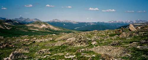
Looking west from Icefield Pass
USGS Quads
Glen Haven
Estes Park
Crystal Mountain
Pingree Park
Comanche Peak
Red Tape
No entrance or parking fees
Backcountry campsites in RMNP must be reserved in advance. A fee is charged per reservation. The Trails Illustrated map shows backcountry site locations. See link below for more detail.
No reservations required for backcountry camping in Roosevelt NF or the Comanche Peak Wilderness. See link below for more detail.
Links
RMNP Backcountry camping info
Comanche Peak Wilderness Rules & Regulations
Roosevelt National Forest