
|
|
Route |
|---|---|
|
|
36.53890°N / 118.2492°W |
|
|
Scramble |
|
|
Most of a day |
|
|
Class 3 |
|
|
Approach
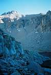
The start of the traverse is reached from the Meysan Lakes trailhead just off the Whitney Portal Road. Hike through the Whitney Portal campsite and across some back roads to the start of the Meysan Lakes trail that climbs all the way up the canyon. From the upper Meysan Lake climb either the Class 2-3 chute next to the creek or the Class 3 snow chute(the next chute North). Once on the saddle scramble up to the base of the Mount LeConte cliffs. Descend down the west side of the ridge 100ft and then climb up into LeConte's Northwest chute. Climb this chute, pass over the infamous waterfall pitch, until a clearly ducked ledge leading South is seen. This is the start of your traverse.
Time to climb is from the Meysan Lakes trailhead.
 |  |
Route Description
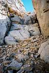
Enter the first ledge approximately 10ft above where it rounds the corner. Follow this traverse through one small chute and around another corner. You will then come into a wide chute that allows one to descend down some slippery gravel. Drop down the chute 150ft to a ledge just below a large pillar(as seen in the picture). Traverse South along ledges, passing over two more buttresses until you enter a large Chute that ascends up to the North Notch of Corcoran. This chute splits twice as you climb up, stay to the right side. As you near the top a large chockstone is visible 15ft above the ground, pass underneith this stone and continue traversing South. Soon a small pillar of stone is encounted, climb up and down some steep class three along right(west) side of these rocks. Traverse around the base of the west side of Mount Corcoran until one reaches an open chute that leads up the South slope of Mount Corcoran. Scramble up this chute to the summit, the register is just underneith the rock on the very top. For the entire route follow the ducks and cairns that have been built along the way. These are your key to finding the way.
 |  |  |  |
Essential Gear
In normal summer conditions no technical gear is required. Good route finding is all that is needed. In the early season the waterfall pitch can be covered with water and/or ice and may require additional tools. Winter ascents often require ice axe and crampons.
Miscellaneous Info
If you have information about this route that doesn't pertain to any of the other sections, please add it here.
PellucidWombat - May 19, 2004 3:17 am - Voted 10/10
Route CommentPerhaps you should emphasize that both buttresses crossed before heading up to the chockstone are both large and continue across the traverse. When I did the route and crossed the first buttress, I saw a second smaller truncated buttress that partially divided two chutes. The farther chute was wide and forked twice, but there was no chockstone! After descending and then crossing a 3rd buttress (2nd continuous one), I was then in the right chute to ascend.
I also took some photos that can help clarify this vague description of where to begin ascending. I'll post the photos soon.