Miscellaneous Details
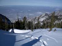
![Early Morning in Bells Canyon]() Morning in Bells Canyon
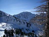
Morning in Bells Canyon![North Thunder]() Upper Lip of Bells
Upper Lip of BellsThe Team:
Myself
Grizz
Peak Climbed: North Thunder Mountain Route: Bells Canyon to Northwest Ridge Date: December 30, 2006 Start Time: 7:07 am Summit Time: 2:43 pm Begin Descent: 2:57 pm Return to TH: 6:04 pm Trailhead Elevation: 5,119 ft. Summit Elevation: 11,150 ft. Round Trip Distance: ±10 miles Elevation Gain: 6,031 ft.
The Hike
![A Glimpse of the Peak]() A Glimpse from our Lunch Break
A Glimpse from our Lunch Break![North Thunder]() Lone Peak from our Lunch Break
Lone Peak from our Lunch Break![Summit Ridge]() Nearing the Summit
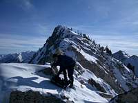
Nearing the Summit![On the Summit Ridge]() Grizz Closing In
Grizz Closing In![North Thunder]() Off with the Snowshoes
Off with the Snowshoes![Summit Register]() Summit Register
Summit Register![On the Descent]() West Face Descent
West Face Descent![Descending into Thunder Bowl]() Headed Down
Headed DownAs this hike began I held little hope of summiting any peaks. Grizz and I were headed up Bells Canyon with a somewhat vague itinerary; North or South Thunder Mountain seemed the most likely objective, but either one would involve a long tedious day, with snow and avalanche conditions undoubtably influencing our route. Although South Thunder would involve a slightly longer approach, it seemed less exposed to avalanche hazard and would probably be more of a 'sure thing'. On the other hand, a winter ascent of the more obscure North Thunder would be so much more satisfying. But still being stuck in the tail end of a week-long head cold I had little expectations beyond a nice day of snowshoeing, hopefully reaching at least as far as Upper Bells Reservoir. So it was with these vague plans that we headed up the Bells Canyon trail shortly after 7:00am, still nearly dark but with enough light from the nearby city to make headlamps unnecessary. Not that Grizz had a choice, since he'd forgotten to bring his headlamp. We made good progress up the packed snow of lower Bells Canyon trail. Keeping our hydration bladder hoses from freezing proved the most challenging aspect of the hike at this point. At roughly the 7000-foot elevation the snow began to deepen so we made a brief stop to strap on snowshoes. After making the gradual turn southward we crossed to the east side of the stream, doing our best to follow the general route of the normal summer trail. Arriving at the open meadow area at approximately 8,000 ft., and a first glimpse of North Thunder, we stopped to evaluate our route. Rather than continue following the general path of the normal summer trail to Upper Bells Reservoir, we decided to take a more direct route up the steeper slopes to the left of Bells Cleaver, which would place us at the lower end of Thunder Bowl and the base of North Thunders west face. This plan effectively eliminated South Thunder mountain as a possible objective for the day. Breaking new trail at this point we began working our way up the gradually steepening slopes, swapping turns at the fatiguing trail breaking duty. We turned our avalanche beacons on and began paying careful attention to route selection as we moved through potentially hazardous areas. Our plan was to reach the small flat meadow area at the lower end of Thunder Bowl, but having never entered the bowl from this approach we were making our way by trial and error. Despite having both been in Thunder Bowl a number of times, things didn't appear quite right, and we struggled to make sense of where we were in relation to where we wanted to be. Continuing onward and upward we finally arrived at the crest of a slope, where our geography suddenly became clear. "Fuck!" We'd somehow managed to work our way considerably to the east of where we wanted to be, finding ourselves on the northwest ridge of the peak, several hundred vertical feet above Thunder Bowl and the route we'd planned to follow to the summit. We were certainly closer to the summit than we'd realized, now only 800 vertical feet and 1/3-mile away, but this was a case where proximity was not necessarily a good thing. The door had seemingly slammed shut on our chances of reaching the peak; "Guess we're not summiting today", Grizz commented. During previous hikes into the area I'd actually looked up and casually studied this ridge, thinking it would be interesting to check out sometime, but on a winter day with the hours until dark running short, this was not the time to be investigating new routes. Feeling defeated we dropped our packs and took a leisurely lunch break on the sunny ridge. After finishing our lunches we packed up and prepared to descend when Grizz decided to take a "quick peek" a short distance above. I commented that the only thing which would get us to the top would be a "nice sloping snow ramp leading to the summit ridge". Yea, right... Although our legs felt somewhat stiff from the extended lunch break, we were pleased to find the going to be relatively straightforward, so we stubbornly continued plodding upward. Reaching another small crest in the ridge we were greeted with a sight we could hardly believe; a nice sloping snow ramp leadin to the summit ridge. Amazed at our apparent good fortune we excitedly began moving up the slope, daring to hope that perhaps we would not be defeated on this day. As we neared the top of the snow slope and began to encounter deep snow fatigue set in, and once again we began to consider calling it a day. "Lets go just a little bit further" was repeated several more times, until we suddenly found ourselves on the summit ridge, the majority of the elevation gain behind us now. With the summit now clearly in sight we'd crossed an imaginary threshold and knew there would be no turning back now. We continued on snowshoes until the ridge became increasingly rocky then stowed them on our packs for the final scramble, arriving at the summit at 2:43 pm, some 7.5 hours after beginning our day. On the summit we dug through snow to locate the summit register which had been placed there by Grizz himself a number of years prior. As North Thunder only receives a dozen or so visitors each year, we were determined to document this relatively rare winter ascent. We took a few photos and attempteed a couple of phone calls, but the chilly wind and late hour urged us to begin our descent. Rather than retrace our somewhat improbable ascent route, we instead began our descent down the south ridge, soon dropping onto the steep west face of the peak. From this point we made a long northward traverse across the face, then descended down a steep slope to the lower end of Thunder Bowl, reversing the general direction of our originally intended ascent route. A bit more routefinding near the bottom of the bowl and we were soon able to locate our ascent tracks from earlier that day, at which point it was all over except for the long walk out. We descended through the last sunlight of the day, then passed through a thick layer of fog in lower Bells Canyon, before finishing the last mile in the dark, following our shadows from the nearly full moon at our backs. We arrived back at our vehicles in just under 11 hours roundtrip. It had been a long and strenuous day, but with a successful ascent of an infrequently climbed peak, on the next to last day of the year, we couldn't have been more satisfied.


Comments
Post a Comment