
|
|
Area/Range |
|---|---|
|
|
41.97938°N / 118.22307°W |
|
|
Hiking |
|
|
Spring, Summer, Fall, Winter |
|
|
8506 ft / 2593 m |
|
|
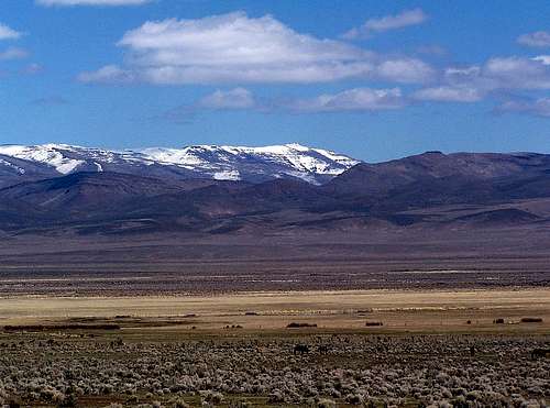
The Most Remote Mountain Range in Oregon
Beyond the driest basins and the highest fault escarpments of Southeast Oregon is the Trout Creek Mountains uplift. Hidden behind a series of foothills along the east side of the Pueblo Valley is a high elevation plateau cut by deep willow lined canyons. These verdant canyons are the distinguishing characteristic of the aptly named Trout Creek Range. Running from the high ridges in the south to the deep valleys of the north are the three fish and beaver laden forks of Big Trout Creek, Little Trout Creek, and the East Fork of Trout Creek. Not high volume streams, most creeks here will run year round fed by springs high along the canyon sidewalls. The side and headwalls are the crests of Mahogany Ridge, Center Ridge, and a lower middle ridge known simply as "The V", all of which are mountains in themselves. Along the canyon walls are random outcroppings of basaltic rimrock laced with shallow caves where you will find marmot burrows and roosting chukars. In many places along the canyons are tight groves of quaking aspen, usually a strong indication that meltwater springs underlay the terrain. Atop the high inner ridges are blankets of mountain mahogany, whereas the drier outside ridges have typical growths of bunchgrass and sagebrush with a few random juniper. As a whole the uplift is dissected by deep canyons along its north and west faces, while the east face is the unassuming East Ridge, a 7000 foot unbroken crest which connects the highest point in the south to the highest point in the northern part of the mountain range. In the south this highpoint is Orevada View; an 8500 foot mountain with three-thousand feet of prominence. Orevada View is essentially the escarpment of the Trout Creek Mountains, and also comprises the bulk of the ranges south border.Like Hart Mountain the Trout Creek Mountains are a large uplift, however this range is tilting slightly to the north and more radically carved by its aforementioned canyons. The Trout Creeks are bordered by the Willow Creek Basin to the North, the Oregon Canyon Mountains fault block to the east (a westward tilting range). To the south across the Kings River Valley is the Nevada range, the Bilk Creek Mountains; and in the west is the Pueblo Valley a deep and narrow basin.
Seen below, the East Ridge with snowcapped Steens Mountain in the background

 Big Trout Creek Beaver Dam
Trout in the Trout Creek Watershed
In Southeast Oregon only a handful of streams can be found that do not dry up in the summer, and very few of these sustain populations of trout and beaver. Some of the streams of the Northern Great Basin harbor endangered populations of Lahontan Cutthroat Trout; unfortunately with the introduction of Rainbow Trout in the 1940's the Lahontan is considered extinct in the Trout Creek Watershed. In the past Trout Creek was known for its large population of healthy Rainbows, but extensive cattle grazing has damaged banks, streambeds, and much of the habitat in general. In recent years land swaps with the BLM has helped to protect some of the creek sides and headwaters, however still expect to encounter cattle at any elevation in the Trout Creek Mountains. ODFW document regarding Lahontan Trout in the Great Basin
Peaks of the North Trout Creek Range
In the north there are only a few named features above the 7000 foot level of the Trout Creek Mountains, most dominant of these is the Mahogany Ridge with a 7162 foot summit at its southern base. Flat-topped Mahogany Ridge travels seven miles in a north to south direction. A rough 4x4 track travels along the summit plain of the ridge, and is accessed from the south end of the Trout Creek Mountain Road.Slightly lower Center Ridge also has a very rough 4x4 road running the length of it, which can be accessed from Little Trout Creek in the north. This ridge has an unmarked highpoint which is roughly 7100 feet. Like Mahogany Ridge, Center Ridge has scattered blankets of Mountain Mahogany across its top and Quaking Aspen in and around rimrock circumnavigating the linear ridge.
Highest of the north-south ridges is the East Ridge with several points above 8000 feet. Midway down the East Ridge is the highpoint of Chick Benchmark at 7879 feet. Furthest north along the East Ridge is the unmarked Trout Creek North Point at just above 7000 feet. This northernmost 7000 footer is an attractive hiking destination for when roads are either snowed in or too muddy to travel. (Trout Creek North Point is seen in the image above left).
List of Peaks:Map of North Area
Chick BM - 7879
Mahogany Ridge - 7162 feet
Center Ridge - 7100 feet
Trout Creek North Point - 7020 feet
Seen below, the north point of Mahogany Ridge

Peaks of the South Trout Creek Range
The highest region of the north leaning Trout Creek Mountains can be found along the southern edge of the fault block. The monarch of the range is Orevada View at 8506 feet. This highpoint is essentially a south facing fault escarpment dropping nearly 4000 feet into the Kings River Valley to the south. While Orevada View has a summit in Nevada, much of the peak crosses into Oregon to the north.A couple miles further north along the East Ridge is Black BM at 8203. Not really a mountain, this is a highpoint along the East Ridge overlooking Sherman Field and the highest named Trout Creek summit in Oregon. Black Benchmark can be walked to from the Trout Creek Mountain Road. Note: Information for Black BM taken from topo map, the name of this location is very difficult to read, and may in fact be called Blacke BM. Without actually seeing the benchmark, for now it will be referred to as Black BM.
The absolute southernmost mountain in the range is Holloway Mountain at 7636 feet. There are really no roads close to Holloway Mountain, the most feasible access is probably from the Kings River Valley in Nevada. Finally, Red Mountain can be found along the western ridge at 6989 feet and is just above the Trout Creek Mountain Road where it reenters the Pueblo Valley. Red Mountain standing alone on the west side of the range has a primitive 4x4 road to the summit of it that would make for a nice morning hike. Red Mountain has a little more than 500 feet of prominence which makes it one of the most prominent peaks in the range.
 Orevada View 3K Prominence Peak
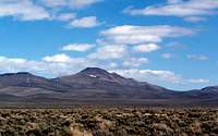 Red Mountain
Orevada View - 8506 feet
Black BM - 8203 feet
Holloway Mountain - 7636 feet
Catlow Peak - 7631 feet
Red Mountain – 6989 feet
Table Mountain - 6308 feet
Buttes of the Willow Creek Basin
 Whitehorse Butte
 Flagstaff Butte
List of Peaks:Map of Willow Creek Area
Buckskin Mountain – 6093 feet
Whitehorse Butte - 6076 feet
Flagstaff Butte - 6029 feet
Willow Butte - 5439 feet
Weather and Logistics
Hiking can be done year round in the Trout Creek Mountains, although many of the inner peaks maybe difficult to access due to poor road conditions. From Little Trout Creek most of the north highpoints can be reached with a day hike even in winter when snow will be deep on the plateau. The majority of the roads above 6000 feet will be drifted in until late spring, so reaching the highest southern points will be difficult until early summer. Mahogany Ridge
Maps of Trout Creek Range
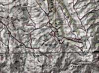 South Trout Creek Map
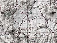 Willow Creek Basin Map
 North Trout Creek Map
Getting There
 Center Ridge and Pueblo Mountain
The Trout Creek Mountains are located directly east of Denio in Southeast Oregon, and extend a short distance into Northern Nevada. Several roads travel into the range, both spur off of the Whitehorse Ranch Road which is located 13 miles north of the Nevada / Oregon state line, or 8 miles south of Fields. Travel 15 miles up the Whitehorse Ranch road to where it leaves the Big Trout Creek Canyon and opens up into a yawning basin, here you will find the Trout Creek Mountain Road.
The Trout Creek Mountain Road travels up Little Trout Creek along the north end of the uplift to the East Ridge, then along the summit plateau south to Sherman Field. This road climbs steeply from the Willow Creek Basin gaining 2000 feet in three miles. you will travel along the East Ridge to Sherman Field where the road then doubles back north eventually down Oreana Creek and into the Pueblo Valley. A number of very rough 4x4 roads can be found that lead in and out of the Trout Creek Mountains, but with the distance from established cities its risky to travel these without a couple spare tires.
Camping
There are no camping areas in the Trout Creek Mountains; however in the Willow Creek Basin to the north is the Willow Creek Hot Springs. This is a small developed campground with a vaulted toilet and an open hot spring tub. The road is smooth enough you could carefully drive a sedan into this campground just a mile off the graded Whitehorse Ranch Road. There is no shortage of undeveloped campsites along many of the creekside roads, especially along Little Trout Creek. Most of these camps have been established by hunters throughout the years, and have been marked on the South Creek Range Map. When camping in this area, be aware of campfire restrictions, and limit the cutting down of aspen as there aren’t many of them out here in the High Desert, and you might incite the ire of an angry little beaver.Red Tape and External Links
Several of the canyons belong to local ranches that will not tolerate trespassing. Stick to the roads and high country, if you'd like to explore property behind fences check with property owners first.Some BLM information can be found for free at Fields Junction.
The Burns BLM can be reached at (541) 573-4400.
The Vale BLM can be reached at (541) 473-3144
BLM Page
Barbara Bond book 75 Scrambles In Oregon
Andy Kerr book Oregon Desert Guide 70 Hikes
 Looking east towards The Oregon Canyon Mountains
Oregon Canyon Mountains

The Oregon Canyon Mountains are a subrange of the Trout Creek Mountains located a short distance east of the Trout Creek Range Proper. Hiking and Peakbagging are rare here, the lone notable summit here being Stevenson BM the range highpoint at 8027 feet. The hidden gem of the Oregon Canyon Mountains is Whitehorse Creek and the deep canyon it has carved through the heart of the Oregon Canyon Mountains.
