
-
 66035 Hits
-
 95.35% Score
-
 52 Votes
|
|
Area/Range |
|---|---|
|
|
41.38241°N / 120.22038°W |
|
|
Hiking, Scrambling |
|
|
Spring, Summer, Fall |
|
|
9892 ft / 3015 m |
|
|
Overview
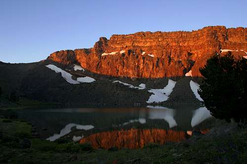
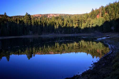
Warren Peak and Patterson Lake aflame at sunrise
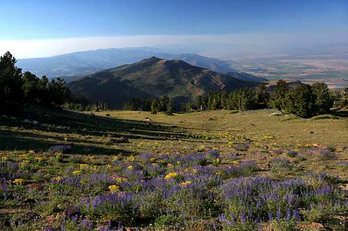
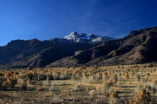
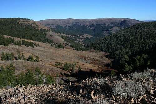
Guarding the northeasternmost corner of California, the Warner Mountains are an isolated mountain rampart. Its peaks stand out as if giant merlons and its lakes seem to be filling spectacular crenellations. These mountains offer some of the grandest scenery, and most unusual terrain and generally unvisited wilderness that northern California has to offer. Indeed, the Warners seem as though they are a range too far, further from a major population center than nearly any other mountains in California. Yet for those who venture into this unusual mountain fastness, many delights await. Chief among them are the spectacular mountains themselves: high peaks, sheer cliffs, gorgeous lakes and ample solitude. Added to this are beautiful creeks and waterfalls, lush meadows loaded with spectacular wildflower displays and some of the finest fall color to be found anywhere in California. Unusual volcanic tuff formations add bizarre variety. A journey into the Warner Mountains will not fail to make a lasting impression on those who put forth the effort.
The Warner Mountains lie at a number of points of transition. Geographically, the range is the point of demarcation between the basin and range topography that characterizes the Great Basin Desert, which lies to the east, and the Modoc Plateau to the west, an area related to the Cascade Range. Botanically, the Warners mark the transition from flora of moister regions to the plants populating desert mountains. Notably, sagebrush and aspen, ubiquitous in the mountains of the Great Basin, coexists with lodgepole and white pine more commonly found in the nearby Cascades and Sierra Nevada. The Warner Mountains are also marked by a political transition. Most of the range, including its highest peaks and most rugged topography, is found within California, though a significant portion of the range extends into southern Oregon.
Lenticular clouds form near Eagle Peak, highest point in the Warner Mountains
For those venturing into the Warner Mountains, the primary destination will be the South Warner Wilderness, the only wilderness area in the range. It is here that the most highly developed trail system exists as well as the most spectacular scenery. Ten lakes exist within the wilderness boundary (though only five of them are really worthy destinations). Chief among these is extraordinary Patterson Lake. Most of these lakes can be visited as part of the premier backpacking trail in these mountains, the Summit Trail Loop. This route follows the crest of the Warners before dropping down below the top of the ridge and scalloping in and out of the many drainages that mark the eastern part of the range.
The Warner Mountains are one of those semi-legendary ranges, a place that few have heard of and far fewer have been to. For those fortunate enough to explore the range, they will most likely have it to themselves (the lone exception to this is Patterson Lake, which would still be unvisited by most standards). It is a lonely, majestic place that promises excellent solitude, incredible and often unusual scenery, and the allure of mysterious mountains seldom seen.
History
Squaw Peak observed from the flanks of Warren Peak
The Warner Mountains are named after Williams Henry Warner, an engineer who was killed in the mountains by Native Americans in 1849. He was surveying passes for possible railroad routes through the mountains. While no rail route was ever constructed, a major wagon trail, the Lassen-Applegate Trail, passed through the mountains from 1846-1850. After this period the Lassen-Applegate Trail began using a different route though some wagon trains continued to pass through the mountains. One such train was crossing the mountains in 1855 when Paiutes fell upon the party and killed the entire group in the midst of the celebration at having entered California. The pass through the Warner Mountains that was used by the wagon trains was named Fandango Pass in honor of this event (the name is intended to recognize the festivities of the party during which the massacre took place).
In response to the Fandango Massacre, the Army sent General George Crook (of future Apache War fame) to pacify the Paiutes. This was in the early stages of the Snake War, a conflict against the Paiutes and Shoshone centered in the Snake River Valley. Crook had a fort built near the Warner Mountains in southern Oregon and named the camp Fort Warner. The camp served as a logistical center for the Army for the duration of the Snake War, but was abandoned in the 1870’s.
Emerson Peak and North Emerson Lake from Cole Peak
In 1912 gold was discovered in the Warner Mountains and numerous mines appeared throughout the range, the most activity was focused around the Mount Vida area. Some claims in this portion of the range remain active. By the time the mines had played out, logging had become the largest enterprise in the range. This industry began to fade out in the 1950’s and the land was left to return to its wild state.
In 1964 a 70,000 acre parcel at the southern end of the range became the South Warner Wilderness, a member of the freshman class of wilderness areas when the law was first passed. Today small mining and logging operations continue in the Warner Mountains, but they are generally minor and unobserved by the few people who venture into these mountains.
Regional Geography
Dusenberry Peak from the Surprise Valley
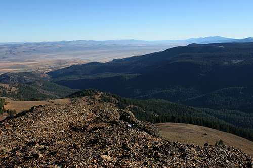
Lying at the junction of two great regions of the American West, the Warner Mountains are an unusual juxtaposition of the alpine and the arid. To the east lies the Great Basin, which stretches from southeastern Oregon and southwestern Idaho across the state of Nevada and into western Utah. The waters tumbling down the Warner’s rugged eastern escarpment are destined never to reach the sea. Rather, they will feed the three massive, intermittent alkaline lakes that lie at the feet of the Warners in the Surprise Valley. To the west stretches the Modoc Plateau, a vast, flat expanse punctuated by cinder cones and low, rounded volcanic ranges. Numerous wetlands are found throughout this region that is an adjacent cousin to the Cascade Range. Waters flowing off of the west side of the range contribute to the Pitt River, which eventually find their way to San Francisco Bay.
Other mountain ranges are found to the north and south of the Warners. North of the range, in Oregon one find the Drakes Peak area. Further north, the same faulting action that produced the Warner Mountains created several massive rim uplifts. Most notable of these is the impressive Abert Rim. Calebeoc has developed an excellent page on these areas and the greater southeast Oregon region. At the southern end of the mountains, the range flattens and fans out, eventually dissipating into a series of low ridges and broad valleys.
The True Pacific Crest
Looking north along the crest and eastern escarpment of the Warner Mountains
An interesting and unrecognized feature of the Warner Mountains is the presence of the true Pacific Crest. The crest begins in Mexico and divides the waters flowing into the Pacific with those that flow to the east. This divide pass along the spine of the Warner Mountains, its eastern waters doomed to the Great Basin while its western waters feed the Pitt River, a tributary of the Sacramento. North of the Warners the Pacific Crest veers west and merges back into the main crest of the Cascade Range. The Pacific Crest Trail flows this divide north, through the Sierra Nevada Mountains and into the Cascade Range. However, north of Lassen Volcanic National Park, the trail deviates from the Pacific Crest. Rather than following the true divide for the waters, the trail passes into the Klamath Mountains, and follows along the divides between the Sacramento, Trinity, Shasta, Scott, Salmon and Applegate Rivers before once again heading east and reconnecting with the true Pacific Crest. If the trail had followed the true divide between the great watersheds, it would have passed along the summit of Warner Mountains and not passed through the numerous subranges of the Klamath Mountains.
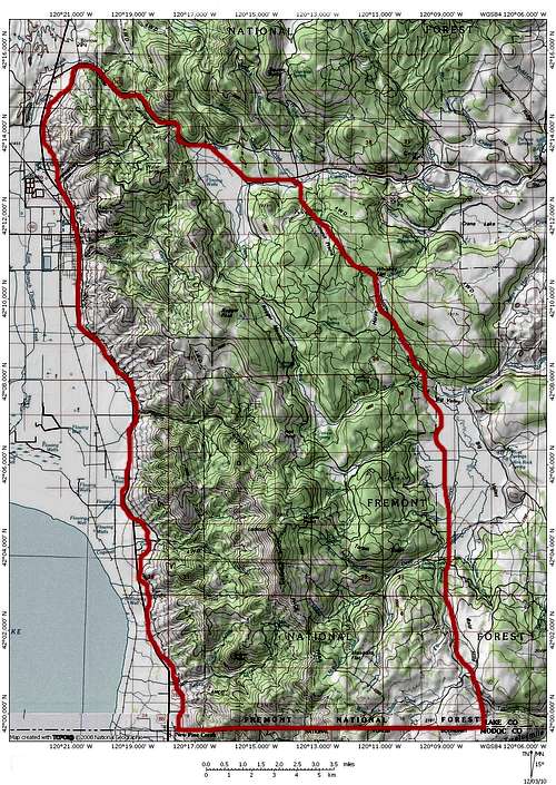
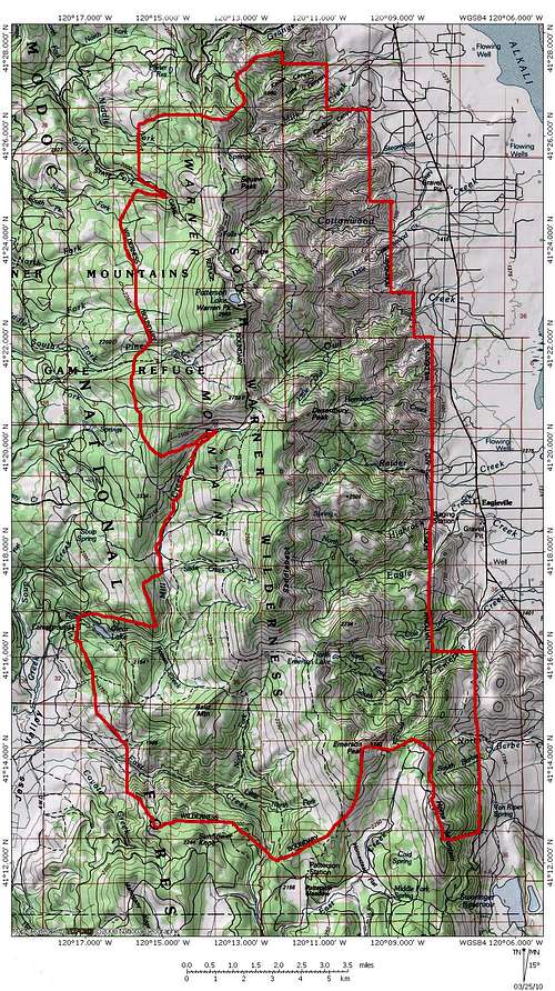
Warner Mountains Map
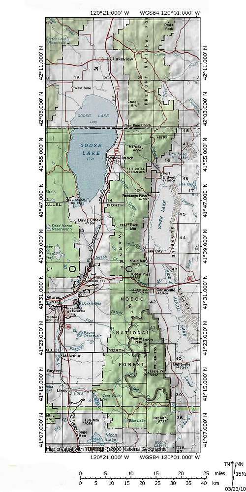
Click to enlarge
Range Topography
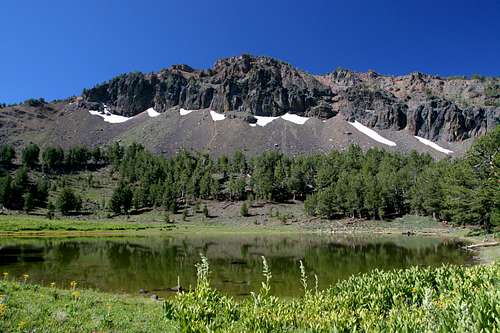
Warren Peak and Patterson Lake
Like most of the mountain ranges in North America, the Warner Mountains are oriented along a north to south axis. They extend nearly 80 miles, from the Red Rock Valley in California to Warner Canyon, which lies immediately east of Lakeview, Oregon. At its widest point, near Eagleville, the Warners are only 15 miles wide. Two passes, Fandango and Cedar bisect the range and provide the only reasonable opportunities to cross the mountains by car.
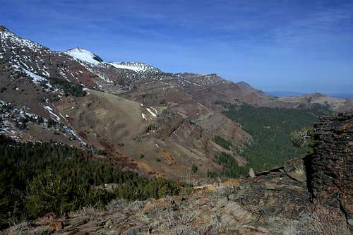
The Warners are a classic fault block mountain range. Like the Sierra Nevada and the Oregon Cascades, the Warners have a long, gradual western slope and a sheer eastern escarpment that drops off dramatically from the summit of the ranges highest peaks. Viewed from the Modoc Plateau to the west, the Warners look mild and rounded, little more than large renditions of hills found throughout northern California. However, looking east from the Surprise Valley, these mountains are rugged and foreboding.
The range lies to the east of the Cascade Mountains. The vast tableland between the Cascades and the Warners is referred to as the Modoc Plateau. It is composed of layers of volcanic flows and periodic volcanic uplifts. Lava Beds National Monument contains the best examples of these, although numerous locations boast similar features, such as the Ahjumawi Lava Springs. Large lakes and wetlands are found throughout the region. The largest lake, Goose Lake is nearly as big as Lake Tahoe and straddles the California-Oregon state line at the foot of the Warners. The western slope of these mountains also feed the Pit River, one of California’s longest rivers and one of only three waterways to transect the Cascade Range.
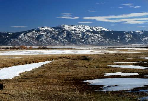
East of the Warner Mountains in California is the Surprise Valley. The eastern edge of this massive chasm is within the borders of the state of Nevada. The Surprise Valley is what is known as a Graben. This is a rift valley that is formed by two plated being pulled apart. Both the Warners and the Hays Canyon Range, which forms the eastern wall of the valley in Nevada, are still slowly rising while the valley floor continues to slowly sink. Three massive alkaline lakes, Upper, Middle and Lower Alkali Lakes are found in the Surprise Valley. Though often dry, it is not uncommon for them to fill up. The valley is home to numerous cattle operations and has a well established hot springs resort.
Volcanic, Not Volcanoes
Volcanic strata visible on Mount Bidwell
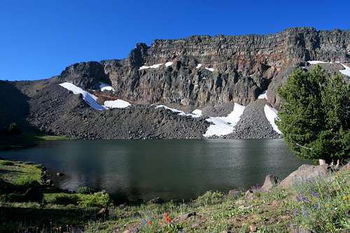
While the Warner Mountains are composed of volcanic rock, they are not volcanoes. As stated previously, they are classic fault block mountains. The rock of the range is similar in composition to that which lies beneath the topsoil of the Modoc Plateau to the west. This area was covered by a series of successive lava flows. Evidence for the flows is seen in the numerous strata can be observed in canyons and certain other parts of the plateau, particularly at the Lava Beds. However, unlike the rest of the region, a massive fault uplifted the Warners, breaking apart the layers and pushing them upwards. This is visible in many areas on the eastern side of the Warners, but the cliffs above Patterson Lake are one of the best examples of this. Layers of at least 11 lava flows can be seen accreted together in the cliffs. Other good places to observe the volcanic strata are in the highest cliffs of the Owl Creek Basin and on the flanks of Mount Bidwell, at the far northern end of the California section of the Warners. Crane Mountain in Oregon also exhibits this phenomenon.
The Northern Terminus
Crane Mountain in Oregon, near the northern terminus of the range
There is some ambiguity about precise location of the Warner Mountains' northern terminus. Many believe the range ends at the Oregon border. While this does seem somewhat arbitrary, it is not entirely without reason, since the highest, most rugged and characteristic parts of the range are only in California. Namely, the only lakes to be found in the Warners are in California. More importantly, it is in California that the range’s eastern escarpment that abuts the Surprise Valley is found. This is one of the distinguishing characteristics of the Warners.
Others believe the range extends far into Oregon and includes the Drake, Light and Twelve Mile Peaks area. Although these peaks are composed of similar rock as the Warners and have similar flora, they are not part of the same fault up lift. This is visible in the extension of terrain beyond these peaks to both the east and the west, lacking a dramatic escarpment so definitive of the rest of the Warner Mountains.
After much discussion with Forest Service personnel, it seems the verdict is that the Warners do extend into Oregon, but terminate south of the Drake Peak area, at the valley traversed by Oregon Highway 140, the Warner Highway. This leaves Crane Mountain as the only major Warner Mountains peak that is in Oregon.
It was pointed by CalebEOC that while the Drakes Peak area seems to be connect to the Warners, these mountains actually appear to be an ancient, blown out shield volcano, similar to Gearhart Mountain. This solution seems to hold water, since the Drakes Peak is on the same fault line as the Warners but is not a result of the fault uplift.
 The Oregon Warners
Peaks
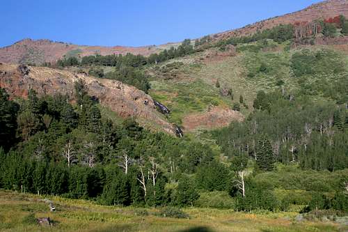
Warren Peak and the Cottonwood Basin from Squaw Peak
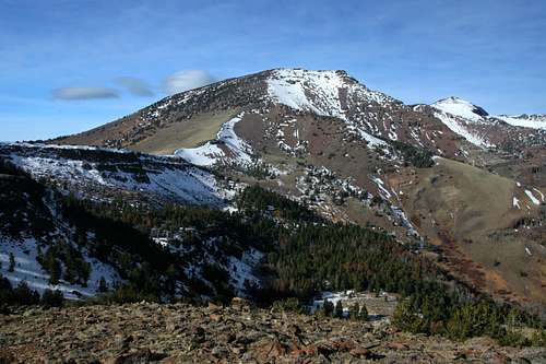
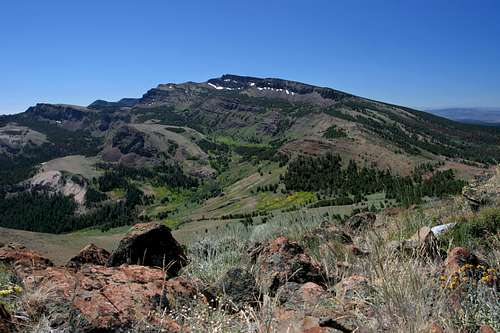
Most of the peaks in the Warner Mountains climb to over 7,000 or 8,000 feet. Three named summits exceed 9,000 feet. The highest of these is Eagle Peak, which attains an elevation of 9,892 feet. This massive mountain has 4,000 feet of prominence. Nearly as tall is 9,710 foot Warren Peak. Though not quite as high as Eagle Peak, this behemoth is easily the most impressive mountain in the range. Chief among its characteristics are the enormous cliffs that mark its northern flank and gorgeous Patterson Lake, which lies at their base. This is without doubt the most spectacular spot in the Warners (though other locations put up strong competition). The last named summit that exceeds the 9,000 foot mark is Dusenberry Peak, which is 9,097 feet high. Other peaks fall just shy of this elevation, notably Cole Peak (8,971 feet) and Emerson Peak (8,989 feet). Though several hundred feet shorter than the aforementioned peaks, Squaw Peak is one of the most prominent summits on the crest of the Warners when viewed from either the east or west sides. Crane Mountain, the highest point in the Oregon portion of the Warner Mountains reaches an elevation of 8,456 feet.
A couple interesting notes about the peaks in the Warner Mountains should be pointed out. First is that Mount Vida is the northernmost peak in California that is part of the Sacramento River watershed, which is the largest in the state. Secondly, the Warners possess two peaks that are county highpoints. Eagle Peak, the highest point in the range is the tallest peak in Modoc County. Further south, Hat Mountain is the highest summit in Lassen County.
Lakes
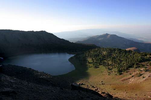
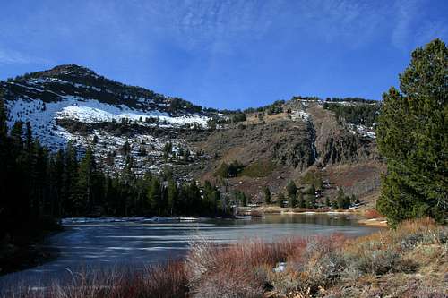
Cottonwood Lake
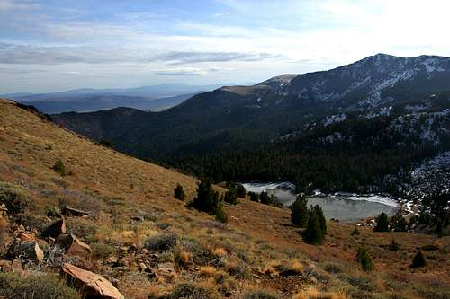
Unlike most mountain ranges in the Great Basin, the Warner Mountains have numerous lakes. The highest concentration of these is found in the South Warner Wilderness. Patterson Lake is the chief among there in terms of depth and beauty. Nearby Cottonwood and Linderman lakes are attractive but shallower. The Mosquito Lakes are shallower still and not particularly attractive. At the southern end of the wilderness area, North and South Emerson Lakes feed Emerson Creek. The northern lake is one of the nicer spots in the Warner Mountains. On the west side of the range and lower in elevation is Clear Lake, which is the only body of water in the South Warner Wilderness that is easily accessed by car. It is the largest lake in the wilderness. In addition to these, there are a few unnamed lakes found in the Pine Creek Basin.
Outside of the wilderness area, a few more lakes are to be found. Chief among these is Blue Lake, a 160 acre gem found in the extreme southern end of the range. Nearby Lost Lake is also a worthy destination. At the northern end of the California section of the range, two more lakes await. Cave and Lily Lakes are the northernmost natural mountain lakes in California.
South Warner Wilderness
Squaw Peak and Patterson Lake from Warren Peak
As previously noted, the South Warner Wilderness is the only protected wild area in the range and was one of the 1964 Wilderness Act’s freshman class. The South Warner Wilderness remains one of California’s most remote and least visited wilderness areas. As the name implies, the area is found at the southern end of the range. It contains 70,614 in an area 18 miles long and 8 miles wide. This is the highest and most rugged portion of the Warner Mountains. It is here that the eastern escarpment, in many ways the defining characteristic of the entire range, is at its most dramatic. There are 7 named peaks and 10 lakes are found within its borders. Nearly 100 miles of trail penetrate the wilderness. The highlight of these is Warner Crest Trail, which traverses the highest portions of the wilderness. Combining this trail with the Squaw Peak and Owl Creek Trails creates a spectacular 45 mile loop that travels above top of the range and then passes below the crest rim through the rugged, eastern drainage basins. Most of the lakes are passed and the highest peaks are close to the Crest Trail. Few venture into the wilderness. Most who do are locals or shepherds, the preponderance of whom seem to be from Peru.
Access to the wilderness area is found at six trailheads. In the north, Pepperdine Camp offers access to the Summit Trail and the Squaw Peak Trail. On the west side, the Pine Creek, Soup Springs and Mill Creek Falls trailheads all lead to the Summit Trail. The Patterson trailhead marks the southern terminus for the Summit Trail. The only maintained access from the east side of the range is through the Emerson Trail. All of these trailheads save Pine Creek are found near Forest Service Campgrounds.
South Warner Wilderness Map
Click to enlarge
Getting There
Getting to the Warner Mountains is a long but fairly straightforward proposition. From nearly everywhere in California, one needs to get Highway 299 and head east to Alturas. Access to the mountains begins from here. If coming from the Tahoe area, the eastern Sierra, or Reno, head north on Highway 395 to Alturas. If coming from Oregon both Highways 140 and 31 provide easy access to Lakeview and the northern end of the range, as well as Highway 395 and points south. If one desires to drive to the Surprise Valley and the eastern side of the Warners, Highway 299 is the only paved route across the range.
Red Tape
Waterfall feeding Cottonwood Meadow
Although the South Warner Wilderness is the only official wilderness area in the range, normal wilderness rules and ethics should be applied in all parts of the mountains. Be conscious of occasional private property inholdings, particularly in the old mining districts around Mount Vida. A free wilderness permit is required for overnight stays in the South Warner Wilderness.
Modoc National Forest (California section)
800 West 12th Street
Alturas, CA 96101
(530) 233-5811
Winema-Fremont National Forest (Oregon Section)
1301 South G Street
Lakeview, OR 97630
(541)947-2151
Camping
Lily Lake in the northern Warner Mountains
As with most parts of National Forests, there is abundant dispersed camping throughout the Warner Mountains. In the California portion of the range, there are 12 campgrounds maintained by the Forest Service. Five of these service the South Warner Wilderness and function as primary trailheads for this area. Campgrounds are found at both Cave and Lily Lakes, in the far northern end of the range. Fandango Pass hosts one campground while two more are found in Cedar Pass. One additional campground is accessed from the west side of the mountains and is found between the two passes. The eat side of the range is graced by one lonely campground on Emerson Creek. At the southern end of the Warner Mountains, a final campground is on the shores of Blue Lake. One Forest Service campground is maintained in the Oregon portion of the Warner Mountains, southwest of Lakeview.
This map gives the locations of the campgrounds found in the California portion of the Warners.
When To Go
Summer has spectacular wildflower displays throughout the Warners. October is also an excellent time to go, since the abundance of aspens means awesome fall colors. Many creeks flow year-round, but the presence of lakes assures the availability of water. The Warner Mountains is often buried in snow until mid-June. The hiking season generally lasts from then until October. The road to most of the trailheads are not plowed and impassable in winter. Access is difficult before the temperatures increase.
Current Conditions
Current NOAA / National Weather Service Forecast for Eagle Peak (southern section of range)
Current NOAA / National Weather Service Forecast for Crane Mountain (northern section of range)
Additional Information
The Surprise Valley and southern Warners from Mount Vida
North Emerson Lake
Water
The Warner Mountains are blessed with abundant water sources. Numerous creeks as well as the lakes provide ample opportunity for hikers and backpackers to refill their supply. The only drawback to the Warners is the presence of sheep and cattle that are put out to roam in the lower elevations for the summer. Consequently, all water in the range should be filtered.
Print Resources
There is an extremely limited amount of literature on the Warner Mountains. It is likely that this page on Summitpost represents the largest repository of beta available for this range. Nonetheless, fragments of can be obtained from occasional hiking books. Most of these focus on descriptions of the Summit Trail.
Maps
The Forest Service provides maps for both Modoc National Forest and Fremont National Forest, which contains the California and Oregon portions of the range, respectively. In addition, the Forest Service prints an good trail map for the South Warner Wilderness.
Logistical Centers
The best place to obtain supplies, wilderness permits and other goods is in Alturas, California and Lakeview, Oregon. Nearly all services are available in these small communities. Limited services are available in Cedarville, California, which is the largest community on the eastern side of the Warner Mountains.
A Note On Taxonomy
Squaw Peak rises beyond Cottonwood Creek
The Warner Mountains are something of an entity unto themselves, not falling neatly into any one taxonomical category. The range is related to the Cascade mountains, but is nonetheless separate from them. The same goes for Oregon’s basin and range region. While the northernmost part of the range does extend into the Beaver State, it is still part of the Sacramento River Watershed and an appendage of a greater California range. In spite of this, the range will be linked to both the California Cascades and Southeast Oregon Basin and Range pages. This is done for purposes of ease of finding the page and the peaks therein.
External Links
-Modoc National Forest
-Winema - Fremont National Forest
-Map of Sacramento River Watershed, including the Warner Mountains and the true Pacific Crest.