
-
 3090 Hits
-
 79.04% Score
-
 10 Votes
|
|
Route |
|---|---|
|
|
46.49021°N / 11.61840°E |
|
|
Hiking |
|
|
Summer, Fall |
|
|
A long day |
|
|
Hike and Scramble |
|
|
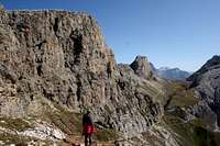
Overview
 Looking into Bärenloch from Grödner Höhenweg Looking into Bärenloch from Grödner Höhenweg |
Like its near namesake Bärenfalle, the route through Tschamintal and Bärenloch at its end is a very strenuous undertaking. Nominally the route ends at Tierser Alpl Hut but you can hike along the Grödner Höhenweg trail above the Tschamin Gorge towards the Schlern / Sciliar Plateau and on to its summit, Petz / Monte Pez. As an alternative the Maximilianweg Ferrata is an even more difficult option.
The hike through Tschamintal is an easy stroll until you reach the cauldron at its end. This far it is a popular hike for flora lovers as the meadows of Schafleferalm are famous for their wildflowers in late spring / early summer. Beyond the character changes to an alpine ascent, which is protected by loose cabling in the most difficult sections. Above Bärenfalle the route changes character again and turns into a Grödner Höhenweg or alternatively into a via ferrata, which combine after Roterdspitze from where it is an easy stroll across the plateau towards Schlernhäuser / Rifugio Bolzano and Petz / Monte Pez.
This route can be combined with Bärenfalle into a very strenuous round trip.
Getting There
 Monte Viodo above Tschamin Gorge
The trailhead is at Weisslahnbad (Bagni di Lavina Bianca) in Eggental. You can reach it as follows:
- Take Brenner Motorway A22 to the exit Bozen / Bolzano Nord
- Switch to SS12 northward until you reach Blumau / Prato Isarco
- Switch to SP24 for a little more than a kilometre, then follow the signs to Tiers / Tires
- Drive through the village to the end of the road at Weißlahnbad / Bagni di Lavinia Bianca
Route Description
 Schaflegeralm at the end of Tschamintal
- General:
- Start altitude: 1200m
- Summit altitude: 2563m
- Prevailing exposure: S
- Type: Hike
- Protection: There are some loose cable in Bärenloch
- Start altitude: 1200m
- Effort: 4 - 1500m elevation gain
- Power: 3 - Long and Strenuous
- Psyche: 2 - Some exposure on the trail between Tierser Alpl and the Schlern Plateau
- Difficulty: 2 - Very steep ascent through Bärenloch
- Orientation: 1 - Marked and easy.
From the parking lot at the end of the Weißlahnbad / Bagni di Lavina Bianca road descend towards the Tschamin Creek and cross it. Follow the wide track into the gorge. It climbs steeply and runs along the south slopes above the gorge with occasional views to the torrent underneath. After a while the path levels while the gorge quickly rises to the same level, making room for a dense but beautiful forest.
 |  |  |
Here you will find occasional clearings the largest of which belongs to Schaflegeralm, a summer pasture for the local cattle. From the left and right the mountains of the Schlern / Sciliar and Rosengarten / Catinaccio Groups draw close forming an immense cauldron with a beatiful meadow at its base.
 |  |  |
The trail now branches: the right hand path heads up to Grasleitenhütte in Rosengarten / Catinaccio while the left hand path leads to the steep gully of Bärenloch. The walls draw even closer as the path heads into the gully, quickly gaining elevation. There is a short protected section, which negotiates polished slabs. Some very steep switchbacks lead out of the gully into the cone-shaped upper part of Bärenloch. Quickly the path leads to Grödner Höhenweg, which heads from Tierser Alpl / Alpe di Tires to Schlern / Sciliar. Turning right you get to the hut and the start of the Maximilianweg Ferrata (see route page) but for the regular route turns left.
 |  |  |
It is a hiking route high above the gorge you came with one or two slightly exposed sections, where it negotiates terrain steps. Going is easy and you quickly reach the upper part of the Schlern / Sciliar Plateau, east of Roterdspitze / Cima di Terrarossa, where Maximilianweg joins. Actually you can climb the mountain easily from this side. From the junction a broad path crosses the plateau leading to the intersection with Touristensteig close to Schlernhäuser / Rifugio Bolzano. Another few easy metres take you onwards to the highpoint Petz / Monte Pez.
Essential Gear
 Within Bärenloch
Hiking gear if you skip Maximilianweg, if not you need ferrata gear (helmet, harness, y-shaped self belaying ferrata set).