
-
 12544 Hits
-
 84.27% Score
-
 18 Votes
|
|
Mountain/Rock |
|---|---|
|
|
39.21330°N / 105.1203°W |
|
|
Douglas |
|
|
Hiking, Scrambling |
|
|
Spring, Summer, Fall, Winter |
|
|
8882 ft / 2707 m |
|
|
Overview
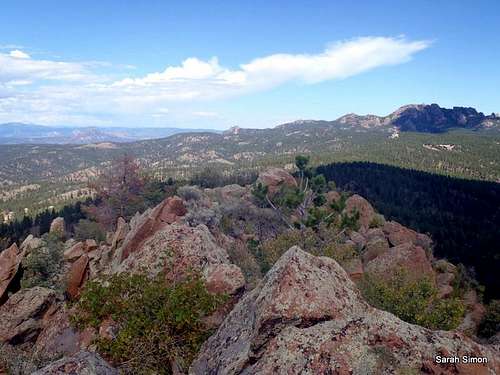
North from Turtle Mountain summit
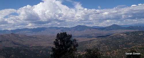
Turtle Mountain is a beautiful little mountain nestled on the western edge of the Rampart Range. It’s a pleasant, rugged little surprise, covered in dense forest but capped but a rocky jumble of granite gables. From the neat, rock-strewn summit plateau, views abound of neighboring Rampart Range peaks. Pikes Peak and Almagre Mountin make quite the statement to the southeast, while the Tarryall Mountains seem surprisingly close to the west. The gnarled, weathered Devils Head raises itself frighteningly to the immediate northeast.
This peak is a reminder that good things often come in small packages. It offers a lot of bang for the buck: A bit of bushwhacking, some easy scrambling and bomber views, all very close to Colorado Springs, Woodland Park and southern Denver. Despite the proximity of Turtle Mountain to the popular Rampart Range Road area, few visitors make it to the summit. Enjoy the solitude.
Rank: 3006th highest peak in Colorado
Prominence: 382 feet
USGS Quad: Dakan Mountain
Planning Map: Trails Illustrated #135 (Deckers | Rampart Range)
Rank & Prominence: Lists of John
Getting There & Red Tape
West from the summit of Turtle Mountain

Almagre Mountain and Pikes Peak
Devils Head from Turtle Mountain
This peak is sandwiched between Rampart Range Road (FS 300) to the east and CO 67 to the west.
CO 67: This approach offers more by way of cross-country navigational challenges and also have private property issues.
Rampart Range Road: This is the most direct approach to Turtle Mountain. The area sees heavy motorized recreation use and is subject to seasonal closures (typically between November and April, depending on conditions).
There are no user fees to access this area and no permits are required.
- Do not litter and dispose properly of human waste.
- Much of Rampart Range Road is a “no shoot” zone. That means: Shoot only in designated target ranges.
- Operate motor vehicles only on designated roadways.
- For everyone’s safety, the National Forest officials segregate street legal, licensed motor vehicle traffic from OHV traffic. Adhere to posted placards managing this traffic. (In plain English: Keep your Jeep off the trails and keep your dirt bike / quad runner off the roads.)
Note the detailed route from Rampart Range Road via the Trout Creek Trail (#649) in the left hand column!
Camping & Lodging

East from summit plateau

West-northwest from summit

Flower in granite

On the summit of Turtle Mountain

Turtle Mountain Summit Register

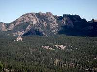
Thunder Butte from Turtle Mountain
Rustic camping in “unofficial” campsites is available throughout the Rampart Range Road area, right off the main road and spur dirt roads off of it. These campsites are available on a first-come, first served basis and provide no services (they are entirely rustic). Most are dry campsites and will require water to be hauled in for cooking and bathing.
Be forewarned that the proximity of this area to the urban I-25 corridor means that crowding can be an issue, especially in the summer, and that unsavory characters are known to frequent this area. Be prepared for heavy ATV use, large crowds, drunkenness and casual firearms usage.
The National Forest Service operates three general-use campgrounds in its Manitou Park Recreation Area. The Manitou Park Recreation Area is located about 5 miles north of Woodland Park along Hwy 67. Below is information about these campgrounds as provided by the Forest Service.
South Meadows Campground: Site has 64 camp sites with parking areas up to 30' long within the 8,000' elevation. Camping season is year round with a user fee of $15.00/per night/per site. The camp-ground has paved roads. Limited sites are reserved by calling 1-877-444-6777. Reservations may be made 240 days prior to arrival and there is a reservation fee. There is also a 2-night minimum stay if your reservation is for Friday or Saturday nights.
Colorado Campground: Site has 81 campsites with parking areas up to 30' long within the 7800' elevation. Camping season usually begins late May and runs until early September. The user fee is $15.00 per night/per site. This campground has paved roads. Limited site reservations can be made 240 days prior to arrival by calling 1-877-444-6777. There is a reservation fee. There is also a 2-night minimum stay if your reservations are for Friday or Saturday night.
Painted Rocks Campground: Area has 18 campsites with parking areas up to 30' long within the 7800' elevation. Camping season usually begins in May and runs through early September. A user fee of $13.00 per night/per site is charged. Limited sites are reserved by calling 1-877-444-6777 and can be made 240 days prior to arrival. There is a reservation fee.
HOTELS
A few simple hotels (many family-run) are available in Woodland Park (elevation 8,465 feet) along with several RV sites and cabins. For more information visit The Greater Woodland Park Chamber of Commerce Visitor Information page.
Weather & Seasons
 | •IMPORTANT: This section of FS 300 (Rampart Range Road) is closed from roughly 1 December through 1 April annually. Exact closure dates can vary year-to-year, so please check with the Forest Service (Pike National Forest) prior to heading toward Turtle Mountain during the transition period. •During the summer months and into early fall, the Rampart Range Road area is very, very busy. It is a popular area for OHV enthusiasts and target shooters. While Turtle Mountain is relatively secluded in its own little nook, expect to climb with the background noise of ATVs and live fire. •In the fall, the days would be cooler and crisp, the aspen turning golden and the likelihood of afternoon thundershowers decreased significantly. |  |