
-
 15333 Hits
-
 81.18% Score
-
 13 Votes
|
|
Mountain/Rock |
|---|---|
|
|
48.07234°N / 121.44248°W |
|
|
Snohomish |
|
|
Scrambling |
|
|
Summer, Fall |
|
|
5840 ft / 1780 m |
|
|
Overview
There are a few different Twin Peaks in Washington state; this is the one up the Mountain Loop Highway just east of Mt. Dickerman. To the north is Mt. Forgotten and Stillaguamish Peak. The South Fork Sauk River is to the east and Barlow Pass is to the south.It is a double summited peak, although they must be fraternal twins because they don't resemble each other. There is some debate as to which peak is taller (see picture below). The easiest solution is to climb both beaks. Besides, you can't really claim to have climbed "Twin Peaks" without climbing both. The following route will take you up to the saddle between the two peaks. The East Peak is an easy scramble from here, the West Peak is a more involved class 4 scramble. Both peaks are quite exposed; the west more so than the east. The West Peak summit is a narrow flake, sheer on both sides.
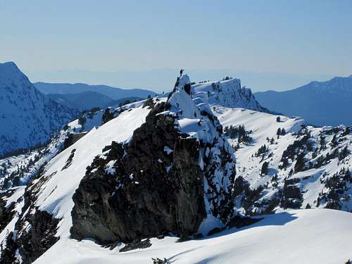 Which is taller? See discussion here.
Getting There
Drive the Mountain Loop Highway about 25 miles east from Granite Falls (just after the Ice Caves trailhead). After crossing Perry Creek, turn left onto Perry Creek Road #4063. Stay left at the fork in the road. It is only one mile from the highway to the trailhead.Hike the Perry Creek/Mt. Forgotten trail to the falls at 2 miles where the trail crosses the creek and begins heading uphill towards Mt. Forgotten meadows. The route begins here at the falls.
Route Description
From Perry Creek Falls, the route follows Perry Creek up the valley to the east. The easiest way of accomplishing this is to just follow the stream bed which is dry in late summer. From the falls, the brush is very heavy up the stream bed for 100 yards or so. It may be easier to follow the trail across the creek and uphill for a short distance, then cut down into the stream bed when you can see it is clear of brush. The other option is just to stay in the woods above the creek the whole way, but there are large patches of devils club along the way. The stream will lead you right into a large basin at the head of the valley.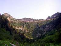 The route up the basin.
There is a cliff band most of the way around and you want to head left up the forested slope roughly following a stream bed. At one point you may see a small mine above you, you want to be right of this. Follow the steep and brushy forested slope straight up (east) to about 4700', where you will come to large cliffs.
 The steep slope.
Head straight up snow or loose rock to the saddle between the two peaks. The east peak is a scramble to the left here. To climb the west peak, go right and start scrambling straight up from the saddle (more on the south side). It is about 60' and fairly easy. You can work your way west a little bit to make it easier. At the top of this you will find yourself at an angled slab with an impressive view of the summit.
The tall narrow tower in front of you is easily bypassed on the left by a narrow (and very cool) ledge under an overhang. On the other side of this things get trickier. Carefully scramble up the loose gully immediately to the right to the notch between the tower and the summit. Scramble up to the left and to the summit flake. From here it is a short but very exposed class 4 scramble to the top. There is not much room on top, perhaps only for one of two people. Be cautious of a large balancing rock that is rather tipsy. The summit was infested with flying ants when I was there. There isn't much to work with for protecting yourself (many of the larger rocks are loose), so be careful coming back down.
Follow the same route down.
 West Peak from the East Peak. You can see most of the route here.
External Links
US Forest Service road & trail conditionsMt. Forgotten trail, Deer Creek Rd #4063
Trip Report from October 2003
Trip Report from May 2000