
-
 317184 Hits
-
 99% Score
-
 95 Votes
|
|
Mountain/Rock |
|---|---|
|
|
48.11179°N / 121.11295°W |
|
|
Download GPX » View Route on Map |
|
|
Snohomish |
|
|
Hiking, Mountaineering, Scrambling |
|
|
Summer |
|
|
10541 ft / 3213 m |
|
|
Overview

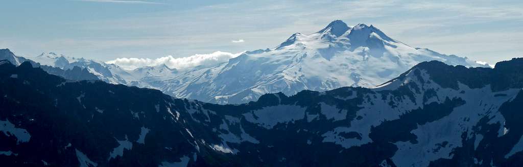
Glacier Peak from the North
Glacier Peak is one of the five volcanoes of the state of Washington, and is the highest mountain in Snohomish county. It has 7498 feet of prominence and ranks 5th highest on the Bulgar List (Washington Top 100). It is located in the North Central part of the Cascades which it has a wilderness named after this mountain which is called the Glacier Peak Wilderness. The Native Americans once called this peak Takobia which would translate to "The Great Parent". This peak is classified as a stratovolcanoe (Composite) which there has not been any major activity in 300 years. This peak goes unnoticed by much of the people of the Northwest due to it being so far in the crest of the Cascades, its distance from the nearest town, and the fact that its access roads have been washed out making all the approaches to its base a long hike in. Glacier Peak can be seen from many locations along the Mountain Loop Highway, North Cascades, Highway 2 area, and many other high points through out the state. But this peak is often hidden from view from many low land areas which is another big reason it goes unnoticed by many. The summit offers amazing views of many of the great peaks of Washington, as well as a view of seeing far across the state.
Evidence of volcanic activity is clearly visible in the pyroclastic flows, ash deposits, and multiple hot springs. As Washington State's most remote volcanic peak, Glacier Peak is completely surrounded by wilderness. Access requires at minimum 10 miles of hiking just to reach a "base camp".
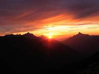
 Sunrise Over GP Sunrise Over GP |
 Sitkum Spire Saddle Sitkum Spire Saddle |
 Standard Route Standard Route |
 Glacier Basin Area Glacier Basin Area |
 The Summit The Summit |
 Glacier Peak from Red Mountain
Routes
South Side via Gerdine and Cool Glaciers: This is currently the standard route up Glacier Peak considering that it's perhaps the easiest way up with the least amount of distance. This route travels over both the Gerdine and Cool glacier which a rope is recommended for this route. The first part of the route is on well maintained trail to White Pass and still trail like until you arrive at Glacier Gap. The slopes to Glacier Peak are moderately sloped almost all the way to the summit.
| Route Name | Duration | Difficulty (alpine grade) | Elevation Gain | Approach |
| Sitkum Glacier | 2-3 days | I | 8200 | White Chuck* |
| Scimitar Glacier | 2-3 days | II | 8200 | White Chuck* |
| Kennedy Glacier | 2-3 days | 8200 | White Chuck* | |
| Frostbite Ridge | 2-3 days | 8200 | White Chuck* | |
| Chocolate Glacier | 3+ days | 8900 | Suiattle* | |
| Cool Glacier | 3+ days | I | 8900 | Suiattle* |
| Disappointment Peak Cleaver/ Gerdine Ridge |
3+ days | I | 8200 | White Chuck* or N Fork Sauk |
* White Chuck and Suiattle approaches are not currently accessible. See Approaches section for details.
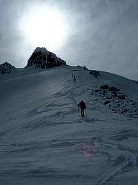
Standard Route
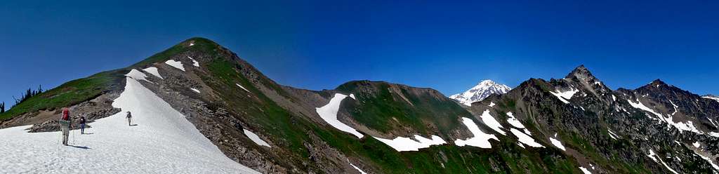
The trail starts out as a gentle hike through the woods which in summer time can have the feeling like a jungle because of the heat, humidity, large trees, and the vegetation that sometimes grows over the edges of the trail. After about 2 miles you reach a junction, be sure to go left (straight), the junction to the right goes up to Pilot Ridge and Johnson Mountain. For much of the traveling the trail remains relatively flat until you are 5 miles from the trailhead which this is where the Mackinaw shelter is. This is a great place to take a break, filter water, or camp depending on how you plan your trip. Immediately after the shelter the trail begins a series of switch backs up the valley, every time I've been though this spot it was always hot during the summer time. As you get higher, you get views of Sloan Peak, Cadet, Mount Johnson, Indian Head, White Mountain, and many other peaks come into view. After traversing the slope of White Mountain you eventually are at White Pass which is about 9 miles (5409 feet high).
 Approaching Glacier Peak from White Pass
From White Pass go left to traverse the East Side of White Mountain, in summer time there is a climbers path that goes over the ridge which goes back into Snohomish County. From here head down into the basin which you can either traverse the bottom of Kololo Peaks or go right through the basin which is recommended when snow covered to save the effort of traversing.
 Glacier Peak in the Morning
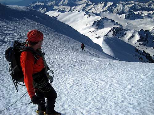
 Traveling on the Gerdine Glacier
 Looking Down from the Summit
Always Remember that 80% of all mountaineering accidents happen on the way down. So even though this mountain is not very technical, watch out for rock fall, crevasses, and watch for bad weather.
More coming later...
Approaches
From the West Side Many of the West side access points to Glacier Peak have closed recently due to massive flooding that occurred in October 2003. Hardest hit were the White Chuck and Suiattle River trails. See the following sites for more info:
Seattle P-I Report
| North Fork Sauk River Trail #649 | |
| Distance | 8.2 miles hike one way to White Pass (~5 miles due south of Glacier Peak Summit) |
| Current Status |
Sloan Creek Road is accessible during normal summer season. Check Road Report for latest conditions. |
| Access | Drive the Mountain Loop Highway 16 miles east of Darrington. Turn left on Sloan Creek/North Fork Sauk Road #49. Park at the North Fork Sauk Trailhead at 6.7 miles. |
| Notes | This is considered to be the best approach currently into the area, though it puts you well south of the objective. This is a good choice for climbers doing the Disappointment Peak/Gerdine Ridge and White Chuck/Gerdine/Cool Glaciers Routes. |
| White Chuck River Trail #643 | |
| Distance | 7 miles hike one way to intersection with Pacific Crest Trail on Glacier Peak's West side. |
| Current Status |
White Chuck Road closed indefinitely at 1.4 miles due to bridge washout. |
| Access | From Mountain Loop Highway 10.5 miles east of Darrington, follow White Chuck River Road 11 miles to road end and trailhead. Before the 10/03 flooding, the White Chuck River Trail was the shortest and most popular route into the area. |
| Notes | Prior to the 10/03 flooding, this was the approach of choice for most climbs including Sitkum Glacier, and Kennedy Glacier. It is now likely that the trail will need to be completely rerouted. |
| Suiattle River Trail #784 | |
| Distance | 14 miles hike one way to Vista Ridge Camp (by way of Milk Creek Trail) |
| Current Status |
Suiattle River Road closed indefinitely due to bridge washout. |
| Access | From Highway 530 north of Darrington, take Suiattle River Road #26 to the road end and the trailhead. |
From the East Side
| White River Trail | |
| Distance | 14 miles hike one way to White Pass (~5 miles due south of Glacier Peak Summit) |
| Current Status |
White River Road is accessible during normal summer season. Contact the Lake Wenatchee Ranger station at (509) 763-3103 for road conditions. |
| Access |
Take the White River Road # 6400 NW from the Lake Wenatchee Area to the road end. |
| Notes | This is an East-Side alternative to the North Fork Sauk approach. |
Getting There
As of July 2013 the road is fully accessible to the trailhead.
Directions to the North Sauk Trailhead (Standard Route):
From Seattle: Drive North on I-5 until you get to Arlington which you take a right at exit 208 onto highway 530. The highway briefly takes a left in down town Arlington onto highway 9 which a few seconds later be sure to turn right back onto highway 530 east to Darrington. From Darrington turn right onto the Mountain Loop Highway (South) for 16 miles which on your left you will see Forest Road 49. If you went past the Bedal bridge, you have gone too far. From here it is around 7 miles of driving on gravel road, near the end be sure to take a left turn which takes you to the trailhead
From Granite Falls: Head east onto highway 92 until you get near the end of the road which here you see many signs on a post. Be sure to take a left here onto the Mountain Loop Highway for about 37 miles. After passing the Bedal bridge take a right onto Forest Road 49 which takes you all the way to the North Sauk Trailhead. But be sure to take a left around 7 miles from the turn off from the Mountain Loop Highway.
For easy directions from your location to the trailhead, check it out on google maps which all you have to do is put in your address.
Red Tape
 A Northwest Forest Pass is required to Park at all of the trailheads for Glacier Peak. The good news is that there are no fees nor permits required for climbing or camping on or around Glacier Peak. Recreation passes can be found at Ranger Stations of the Pacific Northwest, local sporting goods stores, and of course online from Discovernw.org.
For up to date information on Glacier Peak be sure to contact the Darrington Ranger Station.
| Ranger Station | Phone Number | Address | Operating Hours |
| Darrington Ranger Station | (360-436-1155) | 1405 Emens Avenue North, Darrington, WA 98241 | Monday-Saturday 8 a.m. - 4:30 p.m. |
| Verlot Public Service Center | (360-691-7791) | 33515 Mountain Loop Hwy, Granite Falls, WA | 8 a.m. - 4 p.m. |
Camping
There are quite a few options for camping along the way to Glacier Peak. There is camping at the trail head, Mackinaw Shelter, near White Pass, Glacier Basin, and even on Glacier Peak itself. The most commonly used camping places are Glacier Gap and a quarter of a mile from White Pass to the South.
If attempting the Sitkum Glacier route, several fantastic campsites exist in "Boulder Basin", which is accessed via a steep climbers track off of the Pacific Crest Trail.
If attempting the Sitkum Glacier route, several fantastic campsites exist in "Boulder Basin", which is accessed via a steep climbers track off of the Pacific Crest Trail.
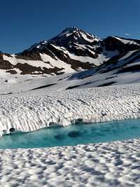
 Near White Chuck Glacier Near White Chuck Glacier |
 Camping at White Pass Camping at White Pass |
 White Pass Below White Pass Below |
 Glacier Gap Glacier Gap |
When To Climb

GP during September
Mountain Conditions
For Weather information check in with the Noaa Forecast.
For Avalanche forecast's check in with the North West Avalanche Center.
For the current Road Conditions for the standard route to Glacier Peak check with the Forest Service for information about the North Sauk trailhead conditions.
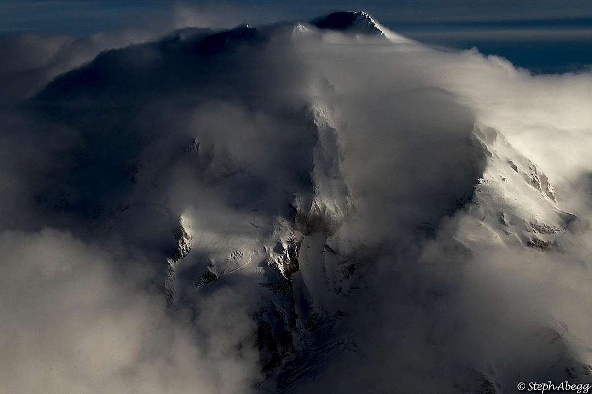
![Glacier Peak Enshrouded in Clouds]() Glacier Peak Enshrouded in Clouds
Glacier Peak Enshrouded in Clouds
For Avalanche forecast's check in with the North West Avalanche Center.
For the current Road Conditions for the standard route to Glacier Peak check with the Forest Service for information about the North Sauk trailhead conditions.
 Glacier Peak Enshrouded in Clouds
Gear to Bring

Drink Plenty of Water

The Gear to Bring
For the Cool Glacier (Standard Route from the South) be sure to bring:
- Ice Axe
- Crampons
- 2 Snow Pickets
- Glacier Rope
- Tent/Bivy
- 3 Days of Food (average time for Glacier Peak)
- Filter/Water Tablets
- Sleeping Pad
- Sleeping Bag
- Glacier Glasses/Goggles
- Sunscreen
- 2-3 Nalgene Bottles (1 Liter Each)
- Camera!
Topographic Maps
 Trailhead (Topo Map 1) Trailhead (Topo Map 1) |
 Mackinaw Shelter (Topo Map 2) Mackinaw Shelter (Topo Map 2) |
 White Mountain (Topo Map 3) White Mountain (Topo Map 3) |
 White Chuck Glacier (Topo 4) White Chuck Glacier (Topo 4) |
 Glacier Peak Summit (Topo 5) Glacier Peak Summit (Topo 5) |
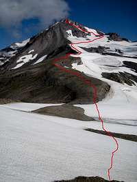
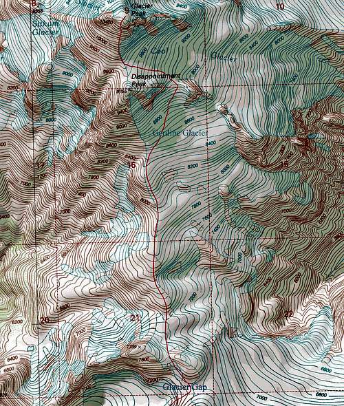
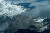
 Sitkum Glacier Topographic Map: Route Drawn out by Daniel Arndt
Experience and Training

Glacier Peak Headstand
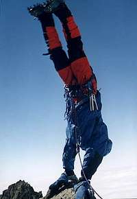
Looking Down
It is advised that you know basic crevasse rescue including z-pulley and self rescue with prusiks or ascenders. If you do not have any of this experience there are many organizations and clubs to learn this. One of the many organizations you could join is The Mountaineers. Before attempting this mountain you should be comfortable with using a ice axe, crampons, and going up semi steep snow slopes. This is not the place for an inexperienced hiker/climber.
For those who are experienced but need partners be sure to post on Nwhikers.net, CascadeClimbers, or here on SP's Plans and Partners Section. Be sure that your going with experienced partners, I've climbed with people who pretend they know what they are doing which endangered everyone on the team.
Like many mountaineers, for my training I climbed many mountains in the area to stay in good shape for this peak. A few peaks for training I would recommend would be Mount Baker, Eldorado Peak, and even Mount Rainier. For those who cannot get into the mountains I would recommend getting into running/jogging, cycling, walking around long distances around town with a pack, what ever gets your legs in good shape for this one.
Wildlife and Flowers
Glacier Peak has many different flowers and wildlife in the area, although on the mountain itself the flowers are limited due to its rugged environment.
 Showy Jacob's Ladder Showy Jacob's Ladder |
 Glacier Peak with Flowers Glacier Peak with Flowers |
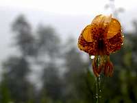 Tiger Lillie Tiger Lillie |
 Marmot Marmot |
Aerial Photography
 Frostbite Ridge Frostbite Ridge |
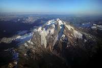 West Side West Side |
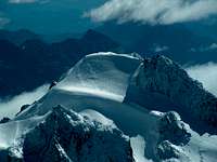 Glacier Peak's Summit Glacier Peak's Summit |
 Access to Glacier Peak Access to Glacier Peak |
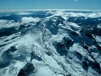 North Face North Face |
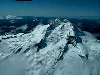 East Face East Face |
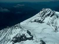 Standard Route Standard Route |
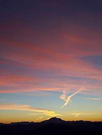
Alpenglow, Sunset, Sunrise
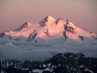 GP from Mt. Maude GP from Mt. Maude |
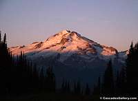 From Minor's Ridge From Minor's Ridge |
 View of Bonanza View of Bonanza |
 Boulder Basin Sunset Boulder Basin Sunset |
 From Cowboy Mountain From Cowboy Mountain |
 Dawn on Glacier Peak Dawn on Glacier Peak |
 Sunset on the Way Sunset on the Way |
 Mount Baker to the North Mount Baker to the North |
 Sunrise Panorama from 9,000 Feet: July 8, 2010
External Links
- White Chuck/Gerdine/Cool Glaciers 9/2/2012 - A modern trip report of the standard route with plenty of eye candy