

-
 4604 Hits
-
 77.48% Score
-
 8 Votes
|
|
Route |
|---|---|
|
|
46.57099°N / 13.21643°E |
|
|
Via Ferrata |
|
|
Summer, Fall |
|
|
Half a day |
|
|
medium hard ferrata |
|
|
The Name

Northen views from the ferrata
Josef Uiberlacher was a well known alpinist from Hermagor, also the president of Hermagor's Alpine Club, who died on Trogkofel / Creta di Aip in 1928. The route was first climbed by L. Enzenhofer and H. Nowak in 1913. In 1927 it was done differently by Uiberlacher who later secured it.
Rating the Route (By Hiking Standards)

Trogkofel / Creta di Aip east face
The grading system for hiking and scrambling routes is here.
0. General: From 1612 m to 2279 m, exposition E and N. First easy hike-up over the meadows, then a short ferrata, finally a steep ascent over a rocky slope. On the Hussler's 6-point difficulty scale for ferratas it is degree 2-3 (B-C). Gear: Good hiking shoes and poles.
1. Effort: cca 680 m, 2 h 15 min.
2. Power: 3 - Medium (only a few places, otherwise easy)
3. Psyche: 3 - Medium.
4. Orientation: 1 - No difficulties (well marked).
Overview
Ascending Creta di Aip / Trogkofel you will very likely do a round tour.
- If you opt to descend by the normal SW route, then the Uiberlacher Weg is the recommended ascent route.
- If you opt to try the Crete Rosse ferrata, then it is better to choose that one for the ascent and descend by Uiberlacher Weg.
All these supposed you have a car on Rudnigalm, of course.
If you look on Creta di Aip / Trogkofel from the NE, you will see a steep rocky face, which does not promise an easy ascent. Nevertheless, the Uiberlacher Weg is not a hard one. There is a place or two, where you need to pull up a bit harder, but in the majority the route is created skillfully, so taking advantage of every weakness of the NE face. Also the scenery is very nice.
Route Description

The ladder

The view from ferrata
From Rudnigalm, 1612 m, we continue by the road southwards, then we deter right, following the marks (Trogkofel, No. 413). The path goes over ski slopes, crosses a humble side ridge and descends on the other side into a broad valley, going among big rocks and boulders. We reach almost 1900 m, just below the E wall of Creta di Aip / Trogkofel, where the key crossroad is. Up on the saddle goes the path around the mountain, but our path (still No. 413) goes right and over the scree slopes up into the east wall.
A short climb brings us into a ravine, which we follow till a steep part, where a ladder and chains help us. On top of it some strength is needed, some more steep sections follow, but then the route starts going towards the right, using the easiest passages. Crossing by a nice ledge it reaches the edge around the NE ridge, a bit above there are nice grassy balconies on it. Now the slopes above us are no more so steep, so the path goes in switchbacks up. We need to walk carefully, use hands to keep balance, but it is not really a climb. So the route reaches again a steeper rock part, which it avoids again towards the right. Here the second part of the climb starts, we scramble more steeply up, and over a few places where harder rocks must be overcome, again a short ladder or two help us. Above we already feel the ridge, a few more minutes and we exit the face just a bit SE of the summit.
The Map
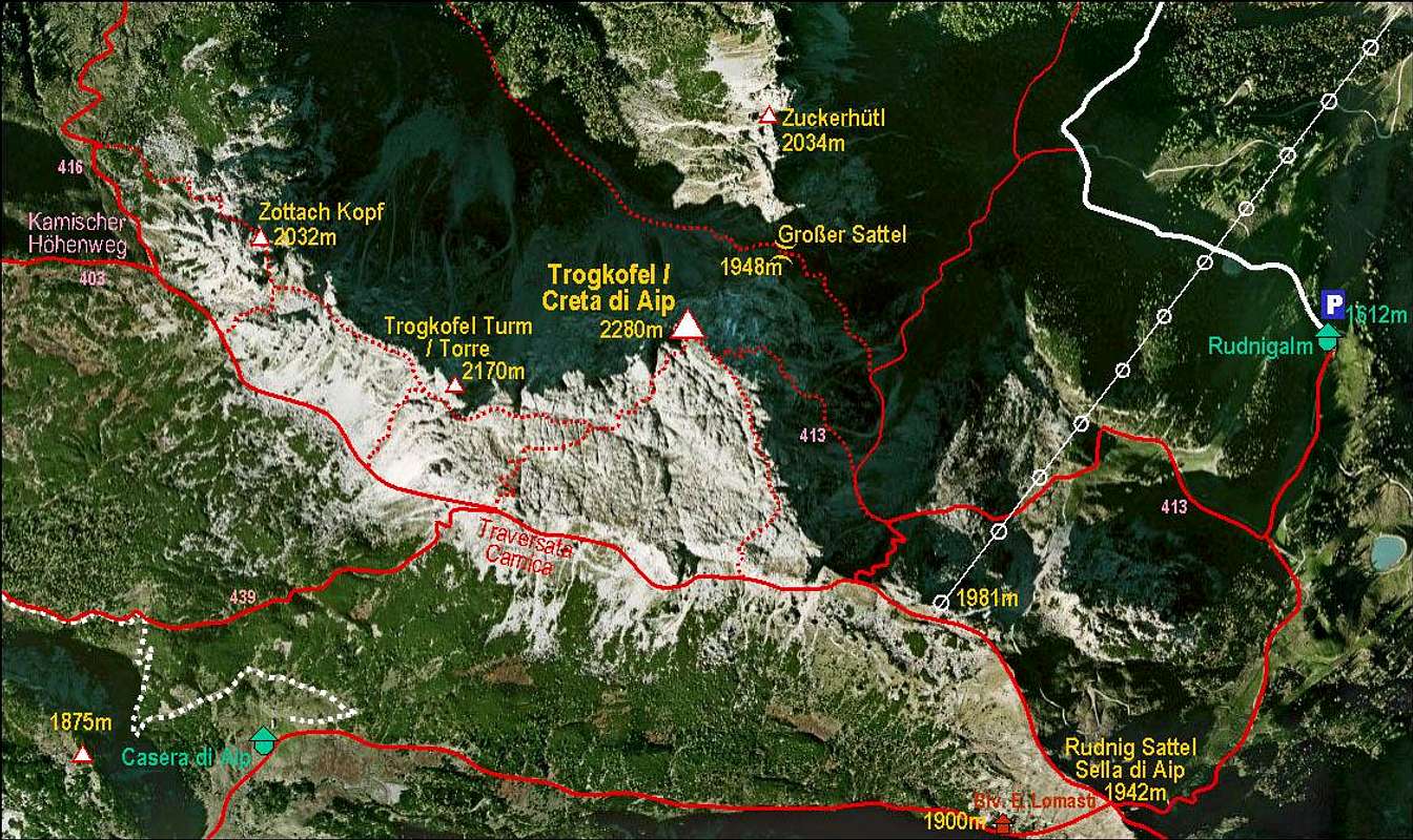
Creta di Aip / Trogkofel and its marked routes