
-
 1744 Hits
-
 77.48% Score
-
 8 Votes
|
|
Mountain/Rock |
|---|---|
|
|
37.96169°N / 107.49555°W |
|
|
Hinsdale |
|
|
Hiking, Mountaineering, Scrambling |
|
|
Spring, Summer, Fall |
|
|
13540 ft / 4127 m |
|
|
Overview
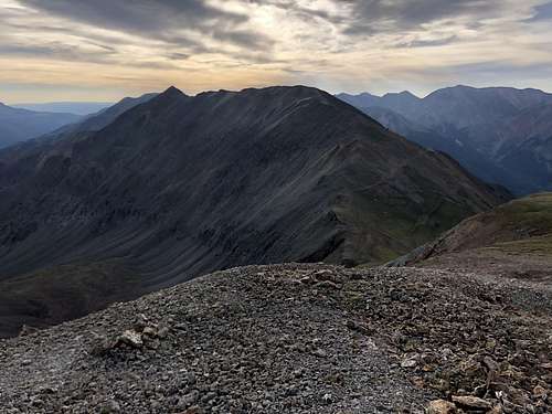 UN 13540 A as seen from UN 13427
Colorado has many 13ers (=mountains over 13,000 feet or 3962 meters), so many of these peaks remain Unnamed. Unnamed A since there is another unnamed peak with the same elevation. It is a ranked peak (unranked summits rise less than 300 feet above the saddle that connects the peak to its closest neighbor). Colorado has 637 thirteeners!
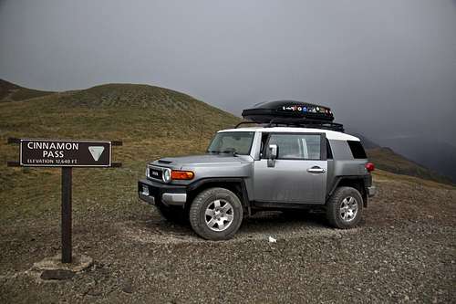
![Cinnamon Pass]() Cinnamon PassThe best way to approach Unnamed 13540 is either via trail along Cooper Creek and hiking the long ridge from Gudy Peak over C.T. Peak, or via Unnamed 13427 starting from Cinnamon Pass.
Cinnamon PassThe best way to approach Unnamed 13540 is either via trail along Cooper Creek and hiking the long ridge from Gudy Peak over C.T. Peak, or via Unnamed 13427 starting from Cinnamon Pass.
Colorado Rank: 225 (tricentennial peak)
Class: 2+
Parent Lineage: Line Parent: 13688
Proximate Parent: "Gudy Peak"
Nearby Mountains:
- Unnamed 13427 1.18 miles
- "C.T. Peak" 1.41 miles
- "Gudy Peak" 2.10 miles
- Whitecross Mountain 2.15 miles
- Sunshine Mountain A 2.45 miles
- Unnamed 13688 2.48 miles
- Gravel Mountain A 2.50 miles
- Wood Mountain A 2.52 miles
- Unnamed 13093 3.00 miles
Getting There
 Cinnamon Pass
Cinnamon Pass - is part the scenic alpine loop connecting Silverton and Lake City. This road is a rough 4WD road and very popular with ATVs. The top of the pass is at 12,640 feet (or 3853 meters).
Or you can start hiking Cooper Creek Trail - signed trailhead below Cinnamon Pass. You do need 4 WD high clearance vehicles for accessing either trailhead. You can either start in Lake City or Silverton. If starting in Lake City, travel south on highway 149, turn onto County Road 30 - signed for Cinnamon Pass and Lake San Cristobal. It is well signed (see also below directions for Cooper Creek Trailhead).
The road is also well marked from Silverton, drive to Eureka, towards Animas Forks (lovely ghost town) and past Animas Forks the road splits to the right for Cinnamon Pass and to the left for Engineer Pass.
How to reach Cooper Creek Trailhead: From Lake City, drive south on 149 and take the turnoff the right for Lake Cristobal. Continue south along the lake and follow the scenic alpine road past the Williams Creek and Mill Creek campgrounds to the intersection for Sherman (winter closure past this area). Take the right fork on start an ascent towards Cinnamon Pass. This section of the road is exposed shelf road. After about 3 miles you pass popular trailhead for the Silver Creek/Grizzly Gulch (access for 14ers: Handies, Redcloud and Sunshine). Continue one more mile to a small parking lot and trailhead sign for Cooper Creek.
Route
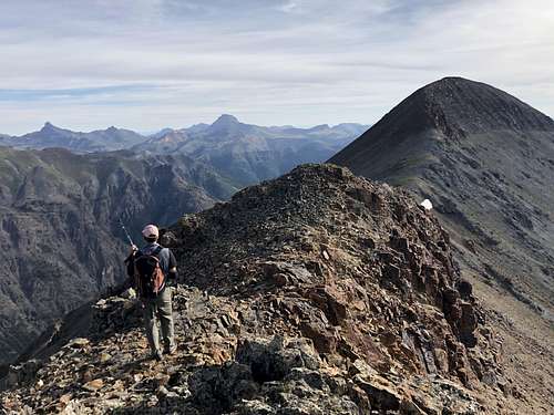 Summit ridge of UN 13540A
I started just a little bit below Cinnamon Pass (on its west side) where I camped the night before. I hiked to UN 13427. The descent from UN 13427 was easy, little steep, crossed the saddle and continued in east direction up the long ridge of UN 13540A. The ridge turns slightly northeast and gets narrow at some places. The views are spectacular and nothing too technical - class 2.
The summit had a small cairn and summit register, which was very wet and I could not sign it for that reason.
The descent towards "C.T. Peak" was more interesting. We decided to stay on the ridge proper, which created some technical scrambling and short section of loose 5th class. I would recommend before heading up some technical obstacles on the ridge proper to drop onto the south scree and bypass towers and ridges. Once you reach the saddle between UN 13540 and "C.T. Peak" the walking gets easy and grassy terrain.
Red Tape
There is no red tape. Driving the Colorado Scenic Highway, parking and hiking are free.When to Climb
Summer is obviously the easiest time to climb with a nice access and safety. Winter adds at least 4 more miles each way to approach Cooper Creek TH and danger of avalanches. Always check avalanche conditions prior venturing out during the winter.
Late spring and early fall may offer good opportunity for exploring this peak.
Camping
There are designated campgrounds at Williams Creek and Mill Creek campgrounds. You can find free primitive camping at the trailhead for Cooper Creek and also at the trailhead at Grizzly Gulch. I have also slept in the car at the top of Cinnamon Pass, and camped below Cinnamon Pass.External Links