It’s a cliché but it really does seem that bad weather follows my family around on climbing trips. A complete whiteout on Mt. Adams one year. A week of thunderstorms in the Sierra the next. 80mph winds during a Mt. Washington winter climb (okay, that last one was actually relatively decent weather, given the context).
Family obligations, career obligations, and living in the Northeast obligations all take their toll on the amount of climbing I get done these days, but I try to take one big trip a year with my siblings. This past summer, we were debating between another visit to Yosemite or going to the Pacific Northwest for a more mountaineering and alpine-flavored journey. For some reason, we decided to use our precious vacation days on an area where you expect it to rain 2 out of every 3 days anyway, and hoped to be pleasantly surprised. We bought tickets to Vancouver (unexpectedly cheaper than flying into Seattle) and crossed our fingers.
The approach
I only had a couple (as in two) days of vacation available, so while my siblings climbed in Squamish I intently studied weather reports and tried to find up-to-date trail conditions for our intended “big” objective for the trip, the Coleman Deming route on Mt. Baker. It seems like every guidebook and website takes pains to mention that Mt. Baker holds the world record for biggest snowfall in a season, and considering my family was on the loose in the PNW I wasn’t surprised to see forecasts for...unseasonable warmth and pleasantness? According to this awesome site, temps were going to be in the 40s on the summit and flirting with the 80s at the trailhead.
Near the trailhead
Stream crossing
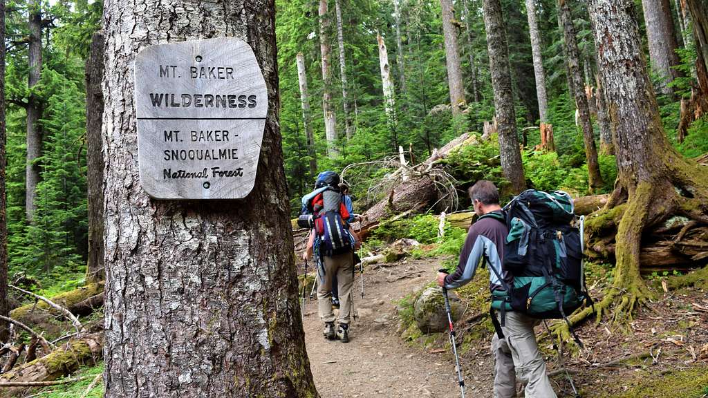
My sibs picked me up in Vancouver on Wednesday night and we crashed in a motel in Abbotsford. After separating gear in a Walmart parking lot, we crossed the border and were able to find the trailhead despite an almost complete lack of cell phone service – just like Mallory! After a long debate about the appropriate pre-glacier footwear (my choices: Chacos, approach shoes, ice climbing boots, or some combination thereof. In the end I went with just the ice climbing boots), we headed up through the dark old-growth forest.
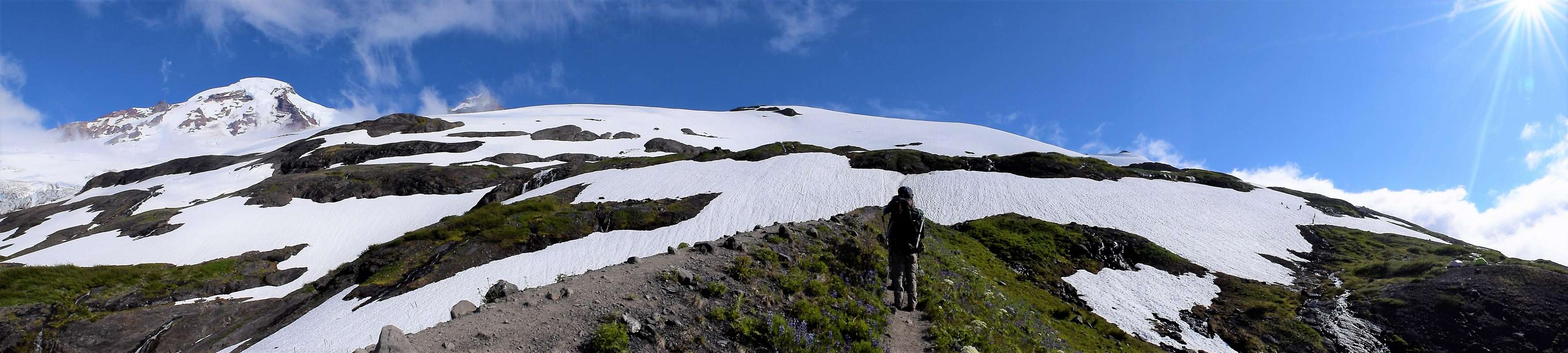
All of the stream crossings were mellow, the switchbacks plentiful, and the hikers who had just gone up to the glacier viewpoint dutifully impressed by our big packs and inappropriately hot footwear. I thought I had read something about the climber’s trail being difficult to find, but in the end it wound up being clearly marked, literally, with a sign that said “climber’s trail.” Not exactly a routefinding challenge.
View from the climber's trail
The summit peaking through
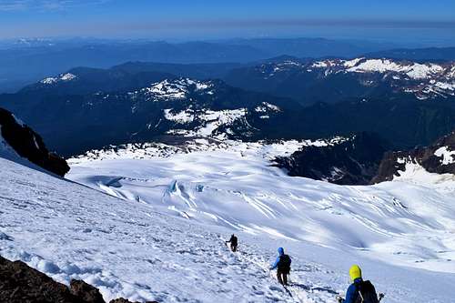
The occasional view through the trees had been obscured by clouds below treeline, but as we started to gain elevation on the hogsback ridge the weather started to lift, revealing meadows of wildflowers rising up to meet the jumbled icefalls on the northern side of Mt. Baker. I love the Northeast and think it’s underrated as a wilderness destination, but, yeah…we don’t have views that look like this.
Base of Coleman Glacier
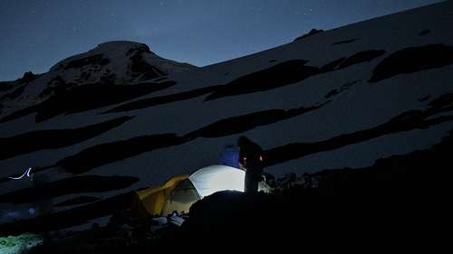
We arrived at the first set of campsites at the edge of the Coleman glacier and started to set up our tents. I recently started using a DSLR and this was the first time I had lugged it on a mountaineering trip. It’s an unfortunate irony that the place where it’s easiest to take pictures (in camp) also has the most boring subjects for pictures so I wound up taking way, way too many photos. Here are a few.
Two climbers scouting the route
Home sweet home
Sunset at camp
Selfie
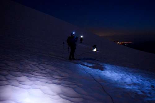
Alpine start
Excessively alpine
We set our alarms and woke up too early (2ish). Then, because we were up so early, we confidently took way too long to get ready, especially since one of us spent a long time trying to figure out how to take night snapshots with their new DSLR (ahem). We were still one of the first teams out of camp. Our tent site was relatively far to the east of the main trail, and somehow we managed to avoid finding the bootpack for about an hour. We were still heading in the right direction (ya know, up), but since my personal previous glacier experience was limited to the equally well-traveled DC route on Rainier I was probably more apprehensive than I should have been walking on unknown glaciated terrain.
Early morning
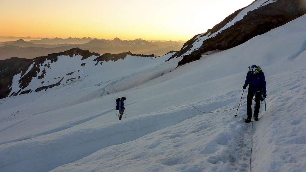
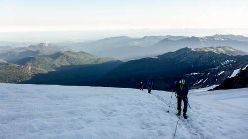
We found the bootpack as the sky was starting to lighten, falling in behind a team from the higher Heliotrope Ridge camp that we would leapfrog with throughout the rest of the day. As the grade started to steepen we began to encounter crevasses that needed to be navigated around, rather than over. There was only a little wind, the sun was rising to reveal a cloudless sky and rows of smaller mountains marching off into the distance, the crevasses were hauntingly beautiful – was I experiencing type 1 fun on a mountaineering trip? Eh, I was probably wishing I had lighter crampons and a bigger variety of Cliff bars at the time, but in hindsight that’s how I remember it.
Sunrise
The struggle is real
Where can you get a good bagel around here?
The sun kept getting higher and higher, just like us. The short sections of hiking to reach the rocky ridge separating the Coleman from the Deming glaciers was, to me, the steepest part of the climb – more so than the Roman Wall above. Once on the ridge we were no longer sheltered from the wind. We were sandblasted with dirt as we tried to pick a path through the scree that didn’t involve a significant downward “settling” with every footstep up. It was, in fact, the first time all day we encountered conditions that could be described by the technical term “sucky.”
Anyway we later learned that a few teams turned around at this point because of the wind. It wasn’t exactly pleasant, but considering everything else about the weather was so perfect we never considered bailing. There was one particular magic spot, right at the edge of the rocky area before starting to head up the Roman Wall, that was somehow sheltered from the wind. We rested, ate, and hydrated there for a while.
Rest spot
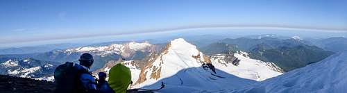
We didn’t set any speed records getting up to the crater rim, but the Roman Wall was a bit easier than expected. We had a motley collection of footwear based on our desired comfort:experience ratio – i.e., I was wearing ice climbing boots and step-in crampons because I have too little experience, while my brother was wearing Sorel’s and trail crampons because he has too much experience. But no one had any complaints other than, ya know, gravity. We reached the crater rim just as the sun was getting high enough to start beating down and overheating us on the steeper sections. Even though I was expecting it I was still a little bummed to see the long but luckily flat walk we’d have to take over the crater to reach the true summit.
Summit and descent
We arrived on the summit at around 8:30 and were able to take in the views to the east and south for the first time. As we were scoping out Prusik Peak, which might have been our preferred goal for this trip if not for the red tape of obtaining permits in a national park, we were joined by a solo climber who informed us that he had taken a few pictures of us on his cell phone just as we were reaching the summit. As I looked and realized these would probably be the coolest photos of us on the entire trip, the camera strap around my neck seemed to dig in just a bit more. Oh well. After my traditional shaky 360 degree summit video with inaudible narration due to loudly blowing wind, we started to head back towards camp.
The trip down was punctuated by many sheddings of layers and watching unroped snowboarders casually slice over narrow snowbridges with a mixture of envy and dread (I’ve been skiing once in my life, when I was 3 years old: it didn’t go well). By the time we got back to our tents I was more than ready to take off my crampons and boots and slide my feet into my comfy sandals. Unfortunately for me, my sandals were still around 2,500 feet below us. After a quick nap and lunch I jammed my poor toes back into my boots and we made our way back down to the car. We had left ourselves an extra day in case of weather or straight-from-sea-level-tiredness, so we spent most of the hike trying to figure out what we should do with that extra day. Eventually we decided to go back to Squamish and enjoyed some more sunny climbing on beautiful granite.
Everything seemed to go right on this trip. The weather was incredible. We had our choice of amazing tent spots (going on a weekday helped). Border agents weren’t confused by a bunch of Americans flying into Canada, then driving to America, then driving back to Canada and flying back to America. The area around Mt. Baker was gorgeous. The Coleman Deming route was in great shape with minimal objective hazards. It was certainly enough of a physical challenge to get our attention, yet still doable coming straight from sea level. We brushed up on our glacier skills and learned some valuable lessons for future trips (sunscreen on the front of the neck is just as important as sunscreen on the back of the neck when you’re on a glacier). What more could you ask for?
As we were driving back to Vancouver to catch our Sunday night flight after a morning of cragging in Squamish, tired, unshowered, and immensely satisfied, I started to nod off in the backseat. Before I could fully close my eyes, I saw a single raindrop fall on the windshield, quickly followed by another, then another, until we were in the middle of a thunderstorm
Parents refers to a larger category under which an object falls. For example, theAconcagua mountain page has the 'Aconcagua Group' and the 'Seven Summits' asparents and is a parent itself to many routes, photos, and Trip Reports.


 Near the trailhead
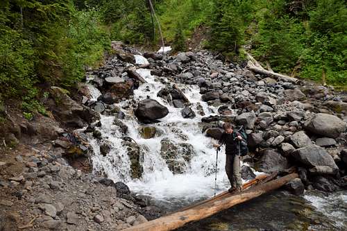 Stream crossing
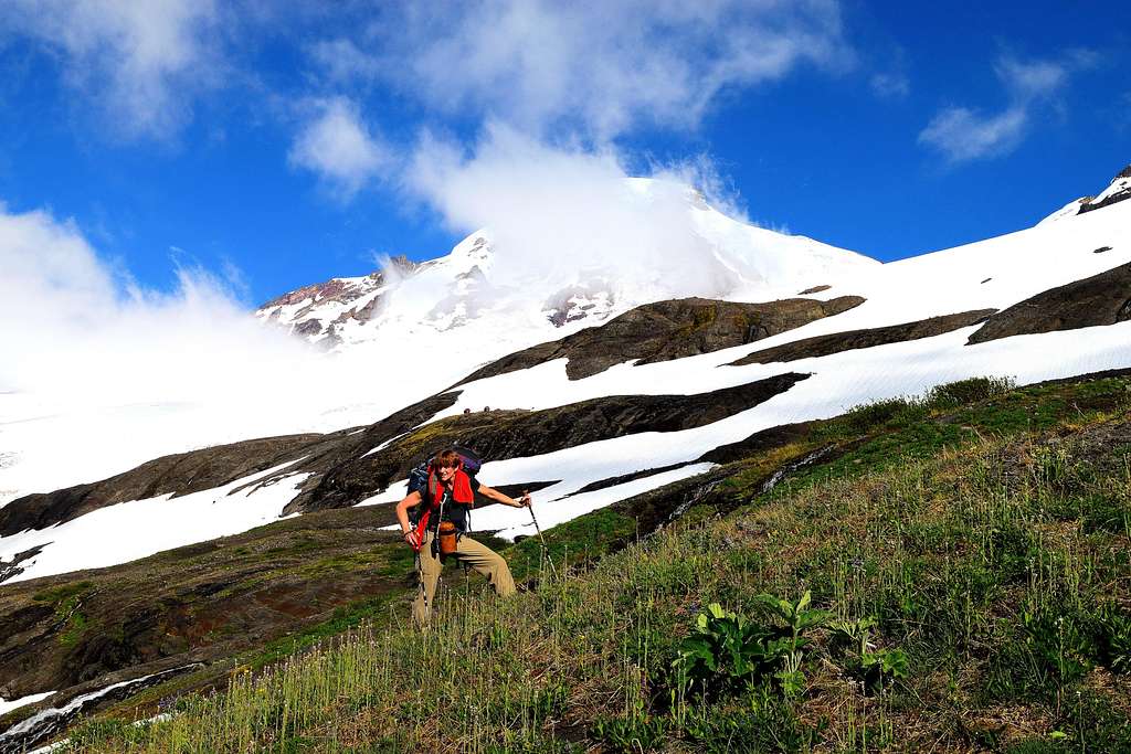 View from the climber's trail
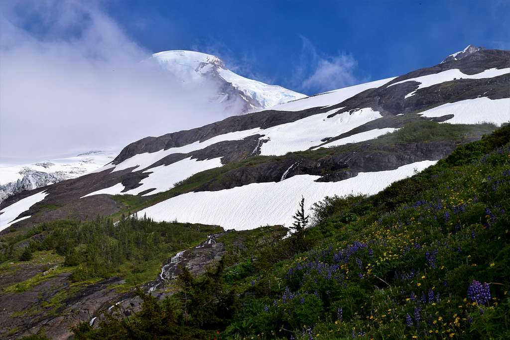 The summit peaking through
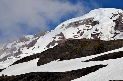 Two climbers scouting the route
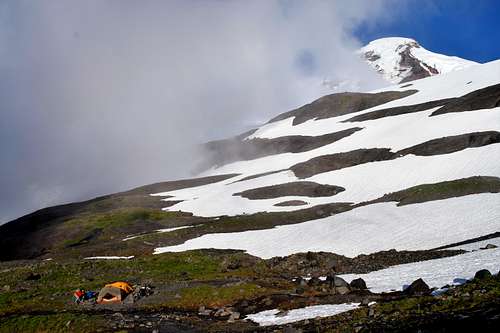 Home sweet home
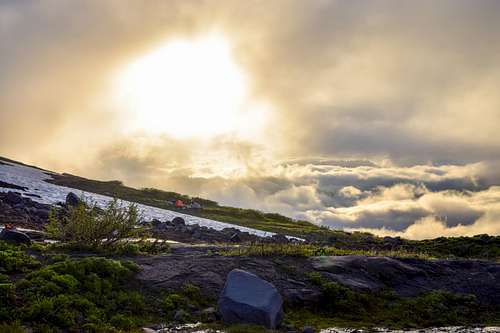 Sunset at camp
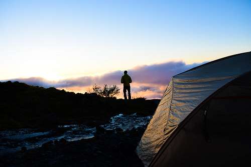 Selfie
