INTRODUCTION
During June 2007, I summited my first big mountain, Mount Rainier. What I did not realize until much later was that summit was only the beginning of a larger journey... one that five years later would lead me to the summit of Mount Baker and become the tenth completer of the Washington County Highpoints. Add on a few extra peakbagging lists, and a little local peakbagging history was made.
PROLOGUE
After summiting Mount Rainier, my primary peakbagging focus became the other State Highpoints. However, I soon realized that attempting the State Highpoints could not be a full-time hobby, especially when living near the West Coast. I needed to find something more localized to my home. But to keep my motivation and interest at a higher level, I knew I had to soon start focusing on specific lists or goals.
During early Spring of 2009, I decided to get some of the Washington County Highpoints (CoHPs) done that had (or might soon have) access issues. I was still not serious about focusing on that list but, just in case I ever would be, my mindset was that any place with an access issue might become more restrictive in the future... so it was best to get those locations summited sooner rather than later.
By the end of April 2009 I had completed 13 of the 39 Washington CoHPs, exactly 1/3 of them. Most of those first CoHPs were otherwise nearly forgettable bumps and hills, but a few (such as Mount Constitution, Quiemuth Peak, and Lilienthal Mountain) were enjoyable. Moreso, for me, regardless of how significant or insignificant, reaching the 33% completion mark gave me the motivation to continue working on the Washington CoHPs in the future.
I was especially intrigued to continue seeking the remaining Washington CoHPs after reading trip reports by other completers and near-completers. Speaking with other local peakbaggers gave me a confidence boost, too. General descriptions of the Washington CoHPs also gave me enthusiasm, such as this overview description posted on the Peakbagger.com website:
There are 39 counties in Washington, and their high points make up the most serious collection of alpine challenges for county highpointers of any state except Alaska. The big volcanoes--Rainier, Adams, Baker, and Glacier Peak--are actually easier to climb than rocky, remote, and rugged giants like Bonanza, Buckner, and Olympus. Throw in a class-4 rock climb (Big Horn), more monster Cascade summits (Daniel, North Gardner), a few forested logging-road points in the southwest, flat farmland points in the east, and other random mountains, and you have a murderer's row line-up of peaks.
By the end of 2009, after also doing other local (non-CoHP) peakbagging and checking my statistics on the Peakbagger.com website, I realized I had reached the 33% completion mark for another Washington peakbagging list that I had not been focused on, let alone known about. That list was the Washington County Greatest Prominence Points (CoGPPs), indicating the point of greatest prominence in each Washington county. CoHPs and CoGPPs are not always identical, and that is true for nearly half of Washington's counties. That meant more peaks and areas to explore in Washington, which I became very excited about.
By the end of 2010, I discovered that my journey to summit CoHPs and CoGPPs also fast-forwarded my progress on another, albeit smaller and less popular, peakbagging list. I realized I had summited over 55% of the most isolated peaks in Washington, also known as the 25-Mile Isolation Peaks (25-Mile ISO). Basically, those are peaks that are separated by at least 25 miles from a higher location.
I quickly decided to complete all three peakbagging lists, preferably at one location if possible. Looking ahead at the peaks yet to be summited on each of those three lists, I soon determined that only two peaks remained which were on all three lists: Mount Olympus and Mount Baker. I had wanted to finish the Washington CoHPs at a different location than those who had previously finished, and fortunately both of those peaks were applicable to satisfying each of those personal aspirations.
THE FINAL COUNTDOWN
After successfully summiting most of the peaks on the Washington CoHP, CoGPP, and 25-Mile ISO lists by the end of 2010, that meant fewer peaks were necessary to complete those lists. However, all four remaining CoHPs (Mount Baker, Mount Olympus, Bonanza Peak, Big Horn) were also on the list of 20 "Apex" CoHPs, those CoHPs in the USA considered the toughest to summit. I knew if I were to be successful with my local peakbagging journey, I was going to need a combination of determination and skill, as well as a little luck.
With good weather windows and conditions, Mount Olympus was summited in early July 2011 and then Bonanza Peak was summited only six days later. Then, only six days after summiting Bonanza Peak, I summited my second-to-last Washington 25-Mile ISO peak, Mount Bonaparte. Two weeks later, I summited my second-to-last Washington CoHP, Big Horn. Then, two weeks after summiting Big Horn, I summited my second-to-last Washington CoGPP, Remmel Mountain (despite unknowingly breaking one of my hands during the ascent).
![At Mount Bonaparte Summit]() Mount Bonaparte Summit, My Second-To-Last WA 25-Mile ISO Peak
Mount Bonaparte Summit, My Second-To-Last WA 25-Mile ISO Peak![A Happy Occasion]() Big Horn Summit, My Second-To-Last WA CoHP
Big Horn Summit, My Second-To-Last WA CoHP![At Remmel Summit]() Remmel Mountain Summit, My Second-To-Last WA CoGPP
Remmel Mountain Summit, My Second-To-Last WA CoGPP
Then the waiting game began. The optimum time to summit Mount Baker, the final peak on the three lists, is not mid-August... and it certainly is not optimum to attempt that peak with a broken hand. So, as I found myself doing low-key peakbagging for several months while my hand healed, I made two new goals: have Mount Baker be both my 100th USA CoHP and 100th USA peak with at least 2000' of prominence. The first goal was short-lived, as I took several trips to Oregon for peakbagging and summited my 100th peak (and beyond) in doing so. Not by coincidence, however, was the fact that my 100th USA CoHP occurred in
Washington County.
So I continued on my other supplemental goal involving USA peaks with at least 2000' of prominence (P2Ks). Entering 2012, including Mount Baker, I still needed 11 USA P2Ks. Living in Washington, where the weather during Winter and Spring does not regularly cooperate for such peakbagging efforts, I figured it would be a tall order to fill. However, I was able to summit several P2Ks during late January while on a trip to Arizona to visit some family members. Then, from early April through mid-May, each weekend in western Washington surprisingly had decent (and sometimes great) weather and snow conditions, ultimately allowing me to reach my 99th USA P2K at Jim Hill Mountain on May 12. Jim Hill Mountain was also my 71st Washington P2K, meaning that my next one (Mount Baker) would be #72, or exactly half (50%) of all Washington P2Ks.
Then "part two" of the waiting game began. With each of my personal goals leading up to Mount Baker complete, all I had to do was summit that peak. One of my closest friends, fellow SummitPost member "Gimpilator" Adam, volunteered to gather and lead the potential summit team. We shared trip pre-planning duties and decided to attempt the peak via the "Easton Glacier" route. Gimpilator had been to Mount Baker seven times, made three summit attempts, and only summited once... via the "Coleman-Deming" route. We agreed that it would keeps things fresh and interesting to summit the peak via a different standard route, and if we had time, health, and conditions to make an attempt of nearby Sherman Peak we would do so.
But what sounded good in conversation and looked good on paper in reality became a frustration beyond our expectations. We set aside each weekend through the first two weekends of June to make a standard two-day ascent with camping included, and we initially had a summit team put together to do so. None of those options would ultimately happen, though.
The first calamity was the weather... which had been so good during much of April through mid-May... turning poor. Rainy and snowy weather on Mount Baker became nearly a daily occurrence. In fact, what few weather windows did occur through mid-June were all short-lived and each came after a major snowstorm had recently bombarded Mount Baker... including several storms that dumped several feet of fresh new snow... raising avalanche danger. One of the primary reasons we originally wanted to attempt Mount Baker during June was to have consolidated snow with minimal avalanche potential... but the weather was not cooperating in that regard. Gimpilator and I eventually arrived at the realization that any decent weather window and snow conditions we might get in June could require us to not only do the trip as a single non-camping ascent but also possibly mid-week. It would be a major single ascent, but one we were willing to try if conditions made it seemingly necessary.
The second calamity was the summit team changing personnel on several occasions. This was due almost entirely to the poor conditions that kept delaying the trip. Several people were only available for specific dates to make the trip, and several other people already had set plans for dates later in the month. As the trip became less date-specific and more "go when we can" Gimpilator and I grew concerned about the possibility of a smaller summit team and the uncertainty of who our teammate(s) would be. However, we remained confident that good mountaineering partners could join us whenever an actual summit attempt would occur.
Finally, during mid-week from June 19-21, a weather window occurred that seemed favorable for an attempt. During several days beforehand, nighttime on Mount Baker had below-freezing temperatures and days were cooler than normal. Avalanche danger was low, too. Gimpilator and I were each able to request time off from work on Wednesday, June 20, meaning we could make a single non-camping summit attempt starting the evening of June 19 through the following day. We also had two people (SummitPost member "fjes6" Joe and his friend Jeremy) available, who were strong enough and willing to join us for this big trip even on short notice.
![Peakbagging Symbolism]() My Mount Baker Triple-List Symbol
My Mount Baker Triple-List SymbolA LONG NIGHT
On Tuesday, June 19, I had to wake up at 4:00 AM and then work for most of a normal workday. I expressed concern with Gimpilator, and later Joe and Jeremy, that I might go slower than normal during our ascent due to lack of sleep leading immediately up to the climb. Everyone seemed to understand that concern, but at least we also realized we did not want the team to push too hard and overexert our energy for a single 7500' elevation gain ascent... so going at a slow-but-steady pace might be preferred by everyone. Fortunately, I was able to get a one-hour nap, which was better than nothing, before meeting-up with Gimpilator.
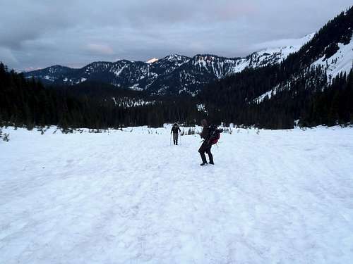
Our four-man team all gathered in the city of Sedro-Woolley and then caravanned in two vehicles to the trailhead... or at least as far as we could drive before reaching constant snowpack (3200' elevation). After parking along the side of the road and finishing packing our gear, we began hiking after 8:10 AM. We actually had to walk on snow-covered road for 0.5 miles before reaching the actual trailhead, which was indistinguishable from the road due to the amount of deep snowpack still present.
Joe was the most familiar with the lower section of the route, and he led the team until reaching the Railroad Grade Moraine. With the large amount of snowpack covering the landscape, he even knew of a few shortcuts that saved us some time without adversely affecting local flora. We had fantastic conditions to start the trip, too. The sky was partly cloudy, the temperature was cool but pleasant, the wind was calm, and the snow was firm but not icy. This was exactly the perfect scenario we had each hoped for.
![Mount Baker - Easton Glacier Route]() Joe Leads The Way...
Joe Leads The Way...![Mount Baker - Easton Glacier Route]() Jeremy & Gimpilator Not Far Behind...
Jeremy & Gimpilator Not Far Behind...
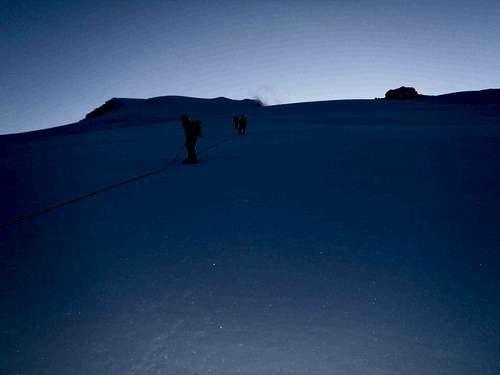
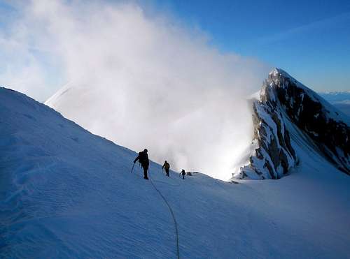
We left a large lower basin and steeply ascended the Railroad Grade Moraine, reaching its ridgeline (5050' elevation) at 9:40 PM. We followed the ridgeline until reaching "Sandy Camp" (5900' elevation) by 11:10 PM. We were happy that enough natural light allowed us to not need to use our headlamps until a short distance prior to reaching Sandy Camp. This is where we decided to rope-up for the remaining ascent, which included extensive glacier travel across crevasse-laden terrain. This was also the location for our longest intended rest stop of the trip. We stopped for snacks, water, and readying our glacier travel gear. After finally roping up and double-checking our gear, we continued our ascent by 11:40 PM.
Gimpilator led the rope team, followed by Jeremy, then Joe, and then myself. Gimpilator and I were the most educated of our team for z-pulley, if needed, which is why we chose to be on opposite sides of the rope as a safety measure in case either end would unfortunately fall into in a crevasse. Plus, Joe and Jeremy were perhaps physically the strongest people on the rope team, so they could help secure and hold a fall on either end of the rope, too. We remained optimistic that none of those scenarios would be necessary on this trip.
AN EVEN LONGER MORNING
Considering the extensive amount of generally poor weather conditions during the weeks leading up to the trip, we were surprised to recent tracks in the snow for us to follow. This was encouraging but short-lived, as the tracks abruptly ended by 8000' elevation at the base of a small incline at approximately 3:30 AM. We were amazed how few crevasses were near our route up until then, to which Gimpilator made the jinx-like statement: "Hey, maybe we won't see much in the way of crevasses!"
![Rope Travel]() Rope Team, 8000' Elevation (Photo by Gimpilator)
Rope Team, 8000' Elevation (Photo by Gimpilator)
Seemingly within moments of Gimpilator making that comment, he heard what he later referred to as a "strange tinkling sound" near the top of the small incline. He took one more step and could see where the tinkling noise was coming from... the largest gaping maw of a crevasse that he had ever stood near. The tinkling noise had been small icicles breaking off the underside of the crevasse lip. We reversed direction and I led the rope team down the incline to look for an alternate route. Looking up to climbers' right, Joe and I could see a possible open approach. Gimpilator, partially still spooked by the maw he had just witnessed and not being able to see the open area that Joe and I spotted, was less certain but trusted our instincts. We backed down the incline further until Gimpilator could then lead the rope team up the alternate slopes.
We had to cross over several small crevasses and cracks along our ascent, but fortunately the cold temperatures and snow helped keep those locations from opening up or collasping. Shortly after 4:00 AM at approximately 8200' elevation, enough natural light had returned that allowed us to no longer need to use headlamps. The fact that we only needed headlamps for five hours was better than we originally expected.
![Mount Baker - Easton Glacier Route]() Nearly Time To Take Headlamps Off!
Nearly Time To Take Headlamps Off!![Mount Baker Shadow]() Mount Baker Sunrise Shadow (Photo by Gimpilator)
Mount Baker Sunrise Shadow (Photo by Gimpilator)![9500 Feet On Easton Glacier]() Rope Team, 9500' Elevation (Photo by Gimpilator)
Rope Team, 9500' Elevation (Photo by Gimpilator)
We reached the summit crater (9800' elevation) by 6:00 AM. This marked the beginning of the steepest section of the climb, ascending the Roman Wall. When Gimpilator had previously been to the Roman Wall several years earlier, the steep slope was very icy and dangerous. However, thanks in large part due to the fresh snow which had fallen on the upper slopes of the mountain in recent weeks, the icy slope was completely covered by snow that was soft enough to allow stable footing and steps.
![Sherman Crater]() Gases Rising From Sherman Crater (Photo by Gimpilator)
Gases Rising From Sherman Crater (Photo by Gimpilator)![Ascending The Roman Wall...]() Lower Ascent Of Roman Wall...
Lower Ascent Of Roman Wall...
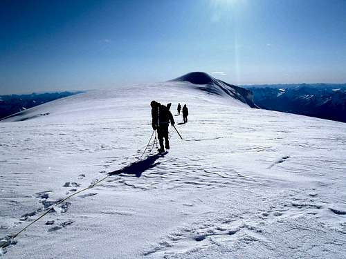
We neared the false summit at 7:15 AM and the slope angle considerably decreased. Then began what seemed to be a long easy walk towards the true summit. Having been awake 26 out of 27 hours, and after having just ascended 7500' elevation during the latter part of that timeframe, I was exhausted. We were all exhausted, but our team kept moving towards the summit still ahead of us. We finally reached the summit (10781' elevation) a little after 7:35 AM.
![Approaching The Baker Summit]() Nearing The True Summit...
Nearing The True Summit...CELEBRATIONS AND LIST COMPLETIONS!!!
When Gimpilator reached the summit, it was the first time he had summited Mount Baker via the "Easton Glacier" route and only the second time overall. When Joe and Jeremy reached the summit soon afterwards, it represented the highest mountain either of them had summited. All three of these guys did a great job on this trip, and each were assets to be a part of it.
When I stepped foot on the summit at 7:38 AM on June 20, 2012, I reached the highlight of my peakbagging journeys up until that point. I became the 10th completer of the Washington County Highpoints, 5th completer of the Washington County Prominence Points, and 6th completer of the Washington 25-Mile Isolation Peaks. This was the first time any combination of those lists had been completed at one location.
I also became the youngest and fastest completer for each of those lists, passing by one of my local peakbagging heroes, fellow SummitPost member Paul Klenke. But when Paul completed multiple major peakbagging lists on Mount Rainier several years earlier it was a far more prestigious accomplishment than the peakbagging lists I had just completed. I only consider my triple-list completion to be "Klenke Lite" at best.
Soon after reaching the summit, Gimpilator said he "found the (USGS) Benchmark." Joe, Jeremy, and I looked him with a puzzled look, as there was no way Gimpilator could have possibly found the true USGS Benchmark under all of the snow. As Joe and Jeremy sat down nearby, Gimpilator handed me one of the best gifts I had ever received... a replica USGS Benchmark disk commemorating my triple-list completion. Gimpilator and I then exchanged handshakes and hugs.
![Mount Baker Summit]() Gimpilator & Redwic At Summit
Gimpilator & Redwic At Summit
After taking several photos, he filmed me making a summit speech. I have created a video incorporating many parts of the speech. Fortunately, I arrived at the summit with various notes already written down, as I had already known I would be tired and possibly forget to mention several key points during the summit video. After making the video and enjoying the views for a while, we left the summit by 8:30 AM.
![The Baker]() The "Baker" Was Cooking Something Special!
The "Baker" Was Cooking Something Special!TIRING DESCENT AND FINAL THOUGHTS
Our descent pace was definitely quicker than our ascent pace had been, although I tweeked one of my feet near the top of the Roman Wall which slightly slowed our team. We could tell it was going to be much warmer this day than the previous day, so mainly out of concern for sloppy snow conditions and crevasse potential our team decided not to attempt Sherman Peak. Fortunately for us, it was still early enough and cool enough in the morning to cross crevasse terrain before any started to open-up further.
![Upper Easton Glacier]() Rope Team Descending, 9000' Elevation (Photo by Gimpilator)
Rope Team Descending, 9000' Elevation (Photo by Gimpilator)
The snowpack remained firm until reaching deep boot tracks at 8000' elevation, soon after which the snow became soft. Each step became cumbersome and tiring as we began to posthole more often the further we descended. When we reached the high campsite known as "Portal Camp" (6600' elevation), we were beyond crevasse dangers for the remainder of our descent route and decided to untie from the rope.
After untying from the rope and taking a short break, Joe and Jeremy wanted to continue ahead at a faster pace while Gimpilator and I took our time to enjoy the scenery and not get over-exhausted. We briefly met up with Joe and Jeremy at "Sandy Camp" prior to splitting into two groups again. Gimpilator and I walked at a steady pace during the remainder of the descent, but we still arrived back at the car only six hours after leaving the summit. We later went to Joe's house to do a final gear-check (i.e. make certain eveyone has their own gear items), and good-byes.
Several of my family and friends called and e-mailed me that afternoon, offering their congratulations. I had brought a SPOT device with me to keep track of our route in "real time" and, surprisingly, most of those people were monitoring our progress that morning when we summited. As a result, they also knew generally when we had completed the trip.
------------
Speaking of family and friends, I could not completed the CoHP, CoGPP, and 25-Mile ISO lists without their occasional assistance and support. That will not be forgotten.
I want to thank each person who helped or accompanied me on those trips.
I also want to give thanks and tribute to those completers of the Washington County Highpoints who were before me:
John Roper, Bob Bolton, Bob Packard, Martin Shetter, Paul Klenke, Duane Gilliland, Edward Earl, Andy Boos, Paul Michelson
To date, I have had the privilege of going on hikes with most of those people, and they really helped inspire me to continue this journey. Now including myself, I will forever refer to these first ten Washington CoHP completers as the
WashingTEN. Here is a map showing where each of the
WashingTEN completed the Washington County Highpoints:
![The WashingTEN]() The "WashingTEN" County Highpointers
The "WashingTEN" County Highpointers
Thank you to everyone reading this trip report, everyone watching corresponding reports and videos, and all of the people who have helped along the way and/or who will in the future. If this journey helps even one person become more inspired or successful with his or her own goals, whatever those might be, then this whole journey will have been worth it.
VIDEO LINKS
Baker Prequel
Some people had wanted to know a little more about the lists and events directly leading up to the summit of Mount Baker. This video takes a look at each of the second-to-last peaks I summited on each list, as well as the Mount Baker trip, itself, until the summit.
Triple Washington Peakbagging List Completion!
This video is basically just a celebratory summit speech. My apologies for the horrible wind-like sound. I do not recall much wind at the summit, but perhaps there was more than I realized. It must have been the angle at which the camera was facing for most of the video segment.
For both videos, on the lower-right of the video screen, I recommend changing the play-view mode to "Large Player" rather than the standard "Small Player" option or "Full Screen" option. I think the videos, especially the second video, look better in "Large Player" mode.
------------
Mount Baker In A Day
Gimpilator created this video for our Mount Baker trip, itself. This video provides a good visual display for the weather and conditions we encountered during the trip.
Comments
No comments posted yet.