
-
 20409 Hits
-
 79.58% Score
-
 11 Votes
|
|
Area/Range |
|---|---|
|
|
41.40978°S / 72.13211°W |
|
|
Hiking, Mountaineering, Trad Climbing, Sport Climbing, Aid Climbing, Big Wall, Scrambling |
|
|
Summer |
|
|
1047 ft / 319 m |
|
|
Overview
At first sight of Cochamo a climber might mistake it for a climbing playground. The horse packer has carried all the toys up the trail, a zip line ride to cross the river, waterslide waterfalls, a book of drawn cartoonish topos and maps to follow, endless fresh pizzas, the happy tinkle of climbing gear in the air, and glowing white granite towering above in all directions. One will soon discover, though, that this is the Cochamo academy where climbers come to work hard with the potential to walk away with a new route or acquired skill.
The valley is a treasure of untapped new route potential and endless adventure. Even if one is not seeking first ascents or even technical climbing, the valley offers countless adventures in hiking and river sports all based around the comforts of the newly built Refugio Cochamo and campground owned by Silvina and Daniel.
The granite towering above the valley offers a bit of everything to climbers. In a single route one can encounter slab, splitter cracks, wet chimneys, seamed up grooves, crystal holds, bush holds, mud mining, and face climbing. There are more than 100 big wall, sport, and crack routes established on the four 1000 meter granite walls and other surrounding formations. The valley is a green chlorophyll wonderland for good reason; it rains a lot. There is a nearby crag, though, that offers dry routes during rain thanks to a huge roof. At times the crux may seem to be the steep jungle trail approaches with heavy packs. While the rock looks tantalizingly close from the valley, most of the routes require a 2-5 hour long approach and recommended high camp.
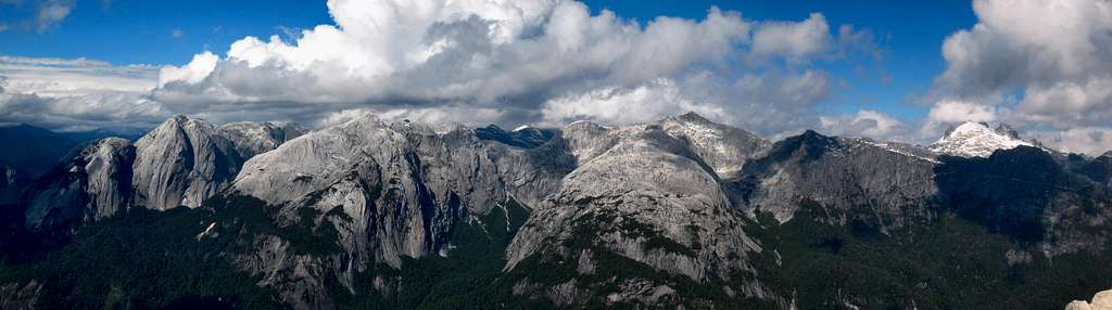
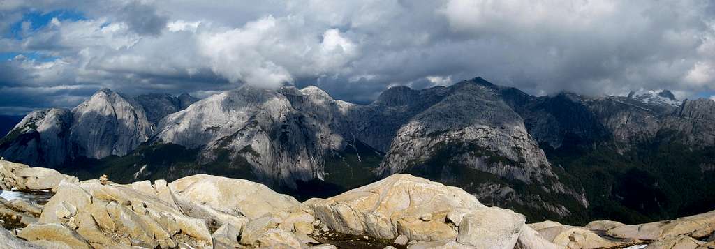 Panorama of the granite domes from Arco Iris
Getting There
The valley is located on the western slope of the Andes along the Cochamo river. Arriving in the valley is relatively easy even with massive amounts of gear. A bus ride from Puerto Montt (where flights arrive daily from Santiago) will drop one off at the small town of Cochamo. It's recommended to hire a taxi or horse service from Cochamó to the trailhead. Horses can continue all the way to the meadow and carry your gear. Fit hikers and those not in a hurry can get off the bus at the bridge three kilometers past town and hike the gravel road six kilometers up to the trailhead. Otherwise tell the bus driver to drop you off at the Pueblo Hundido part of Cochamó.
I recall the bus leaves once daily in the morning around 8am and also stops in Puerto Veras. One with loads of gear and food can wisely hire horse packers from town or along the way to the trailhead for 10,000-20,000 pesos per horse. Free from a heavy load, one can enjoy the well traveled and muddy trail up the valley and through the forest. Beware the 8 foot deep chasms that have been carved out of the mud from horse traffic! The La Junta meadow is reached about 10 kilometers from the trailhead where Daniel and Selvina offer affordable camping with the best views. Across the river they also run the Refugio Cochamó that offers baked goodies, good company, route topos/descriptions, and endless first hand beta. The Campo Adventura facility just west of the refugio on the south side of the river has recently been closed, and the land owners ask that hikers and climbers avoid their property.
If you wish to avoid the buses, the small climbing shops in Puerto Veras rent cars for about $50/day. Hunter Rent-a-Car in Puerto Veras also has a few cars but this is only a good idea if you plan to be visiting many different spots in the region. If you plan to stay your whole trip in Cochamo Valley, take the bus!
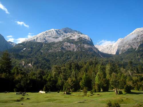
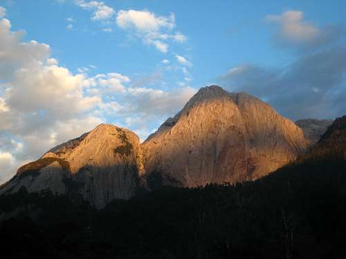
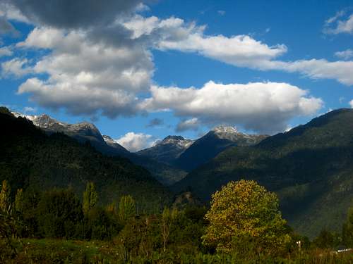 View of the mountains from the town of Cochamo View of the mountains from the town of Cochamo |
 La Junta Meadow at dawn La Junta Meadow at dawn |
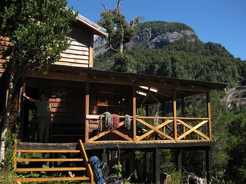 Refugio Cochamo Refugio Cochamo |
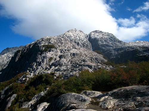
Arco Iris Scramble
Arco Iris is probably the best "hike" in the valley. A relentless, steep hike involving fixed hand lines and good exposure takes you to treeline and a spectacular view point on the north side of the valley. From here, you can continue to scramble up to the summit and be rewarded with some of the best views you will probably ever see. Although this is certainly a serious scramble, trekkers comfortable with exposure and handlines should be able to make it. If big drop-offs scare you or you haven't done any very steep trails requiring use of your hands extensively, then consider passing on this route.
Begin by hiking past the bathrooms towards the horse corral on the north side of the meadow. A sign for Arco Iris will point to the left just before the corral. As soon as you enter the trees the trail begins climbing. This is the same start for the approach to the La Paloma Wall which guards the north side of the La Junta River where it dumps into the Cochamo River. This wall is also visible from the meadow as the large wall directly above to the north. After 10 minutes or so up the trail, you will reach a junction where you must turn sharply left. Staying straight will bring you to the La Junta River and the continuation of the approach to the La Junta Wall.
The trail up Arco iris continues to climb very steeply for at least an hour. The trail will reach a point where it flattens out and begins a horizontal traverse to the right. It's very narrow and exposed in places here but you are still in the trees. The trail then reaches an overlook of the La Junta River below, and will curve left and reach the base of a wet slab with a large tree growing from it. This is the most difficult part of the route as you will need to use the handlines to climb up the slab with dripping water getting you wet. About 20 feet up the slab you can then use the tree roots and make your way once again to the left up a dirt gully with more handlines. A fall here would very likely be fatal but the handlines were in good shape as of April, 2014. If you can make this section you can make the summit. Beyond this, the trail is a little more gentle as it traverses back westward and reaches a great viewpoint.
You will then reach a set of two slabs with handlines bolted to them for aid. Without them, the climb with be very hard and by this point you are out of the trees so the exposure and views is more exhilarating. Once above these final slabs, the trail reaches a broad ridge crest and continues steeply through thinner trees and emerges at treeline and the viewpoint, where the official trail ends at 4,000 feet elevation. A very small elevation range of alpine plants exist (perhaps only 100 feet or so) then quickly turns into solid granite. The summit from here is clearly visible to the NNW and is the peak to the right of the large gash dissecting the mountain above.
To summit, continue scrambling up now low angle granite slabs near the crest of the east ridge and following cairns. When you reach the base of the cliffs guarding the summit area, traverse west at about the 4,600 foot level along the south side of the peak. You will pass below the cliffs as you traverse, and eventually locate a series of gullies that you can ascend and meet the south ridge of the mountain at roughly 5,000 feet. From here, scramble up the ridge, staying mostly on the crest to the summit. The final 150 feet to the top of the SE peak will utilize a series of ledges just to the right side of the crest. The difficulty will not exceed Class 3. From the SE peak you can descend a couple hundred feet northward and continue on the ridge in a NW direction to the main high point of Arco Iris, which is about 200 feet higher than the SE peak. Another, even higher and unnamed peak off to the west opposite a large blue lake is the highest peak in this group.
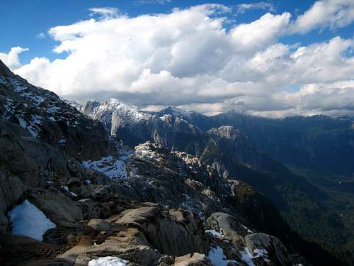
From the summit you command a very powerful view that words cannot even come close to describing. If you want to get above the trees but cannot, or do not want to do any technical climbing, this is by far the best thing to do. Here's some photos:
 Looking up at Arco Iris (right peak) Looking up at Arco Iris (right peak) |
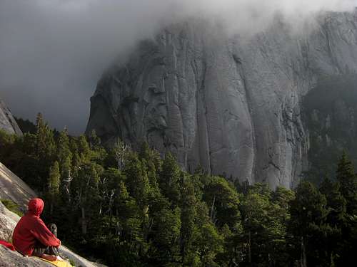
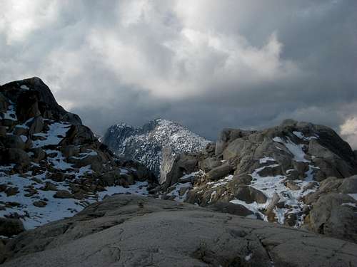 Clouds rolling in on the route up Arco Iris Clouds rolling in on the route up Arco Iris |
 Route to Arco Iris Route to Arco Iris |
 Cochamo Valley Panorama
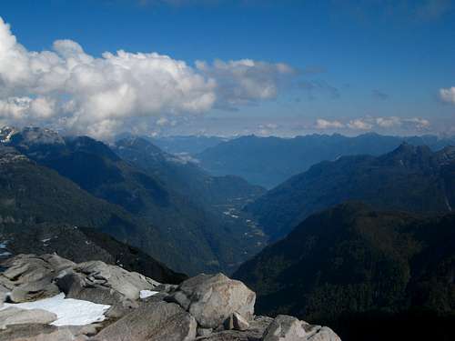 Looking down Cochamo Valley from the top of Arco Iris Looking down Cochamo Valley from the top of Arco Iris |
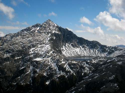 Unnamed peak and lake just to the west Unnamed peak and lake just to the west |
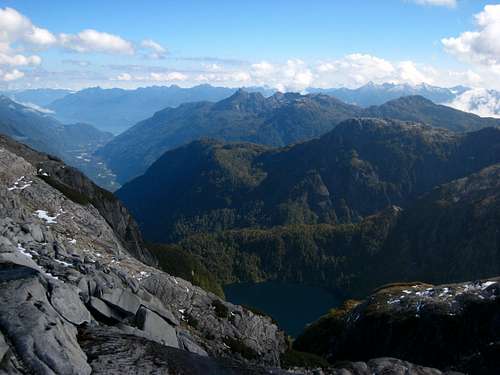 Another unnamed lake seen from Arco Iris Another unnamed lake seen from Arco Iris |
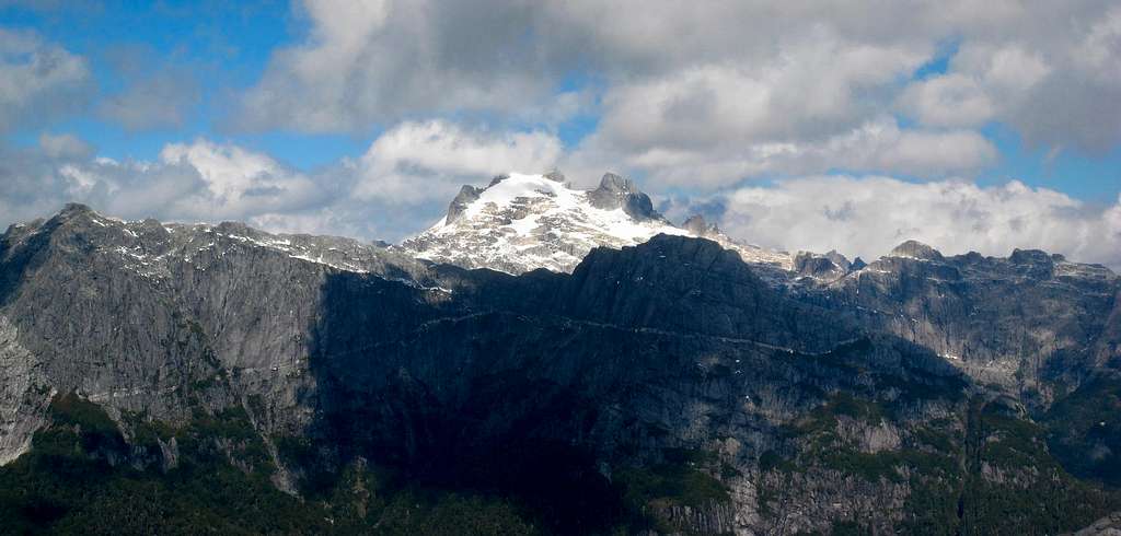 Un-named 6,000 foot peak to the south
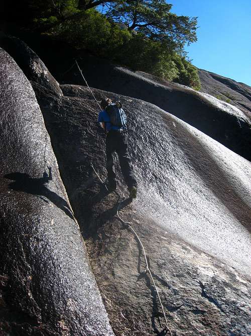 This is a hand line...not a rappel! This is a hand line...not a rappel! |
 View from the meadow at La Junta View from the meadow at La Junta |
Send it Like Santa - 5.10d - 11 Pitches
Although there are hundreds of routes that have been done, particularly big-wall routes in excess of 10 pitches, this is the only route described here on SP. For information regarding more routes while visiting, go to the refugio and talk to people there, or look at the white binder in the small hut full of sketched route topos that appear to be overflowing out of the book. First ascent by Gabe Kelly, Jordan Lamarch, and Sean Post in April 2012.
This route climbs up one of the flanks of Cerro Trinidad, which is the prominent granite dome to the southeast of the meadow. This is also perhaps one of the few 10+ pitch routes in the valley that is less than 5.11 in grade. To get to the base from the meadow, cross the river on the trolley-like wooden basket that hands from the cables. You will see this just before you reach the meadow on your hike in. Basically hop into the wooden barrel and pull the cable to slide across the river!
Once across, follow the trail for the Trinidad Valley (consult the maps). The linked trip report below does a great job explaining the route pitch-by-pitch. A great bivy spot is under the large overhanging rock partway up the Trinidad Valley. Ask at the refugio for detailed directions. Only the first pitch and the last 3 pitches are 5.10 with the remainder of the climb averaging 5.8. All the belay stations are double bolted and the route required double 60 meter ropes with a double rack to 3 inches, stoppers and a 4 inch piece. See the report below:
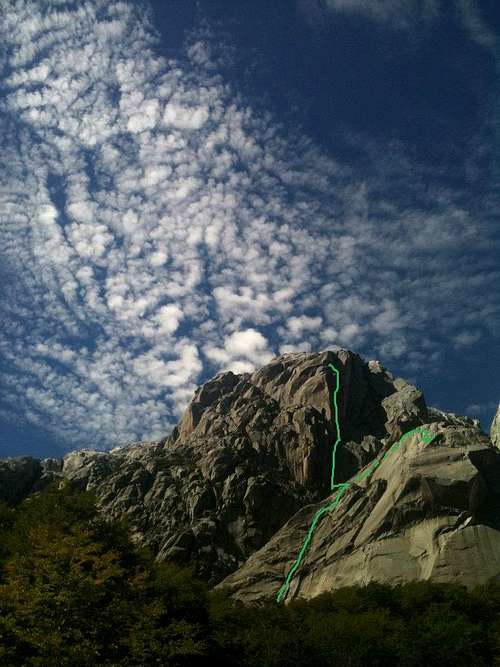 View of the Route View of the Route |
 The Chimney Pitches on the upper part of the route The Chimney Pitches on the upper part of the route |
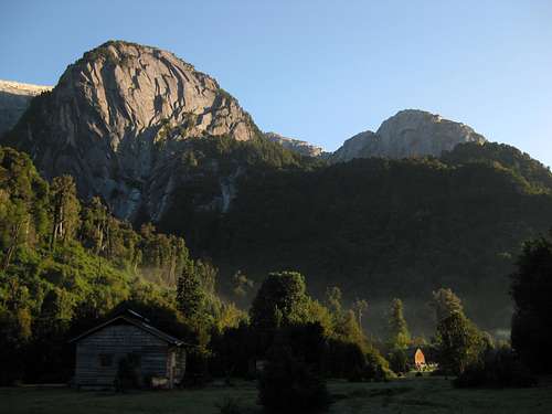
 Sunset on Cerro Trinidad from the Meadow Sunset on Cerro Trinidad from the Meadow |
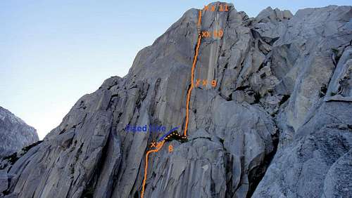
Route Description for EZ Does It - Another moderate multi-pitch route on Cerro Trinidad
 The Water Slide
The Waterslide
Another hidden gem this place has to offer is a natural waterslide! When it's sunny and not cold, there is a granite slab with water flowing over it that is so smooth, it can be slid right on top of. Even better, the low angle water slide dumps into a large, deep pool. The easiest way to find it is to consult the wood carved map at the center of the meadow, but basically just take the trail as if you were going up Arco Iris, and continue straight towards the La Paloma wall and the waterslide is in the La Junta River just a few hundred yards above where it dumps into the Cochamo River.
The Water Slide
Camping/Red Tape
You can camp at the La Junta meadow, where the La Junta river joins the Cochamo River for 5,000 pesos per tent, per night. There is a small hut with a picnic table and fire pit for cooking and escaping the rain and the refuge on the south side of the river offers excellent lodging and hot food but isn't cheap. Please respect the owners of the land as the entire valley is privately owned. In peak season during January and February, the meadow will be very busy so be prepared to make new friends on rainy days!
EmergenciesThe closest hospital is located in Puerto Varas. The town of Cochamó provides medical assistance only for minor injuries. Getting an injured person evacuated to Puerto Varas's hospital may take at least a full day. Helicopter rescue is rare to non-existent. The Cochamó police will assist in rescues if they can be notified. Communication from the valley to town is not guaranteed but a satellite phone and radio communication is available for emergencies.
Please keep this in mind when climbing routes and try to learn as much as possible about your route before climbing it. Please minimize dangerous falls on new routes. Report dangerous run-outs, loose rock, bad protection and other dangers to the refugio. Remember, that a serious injury can result in death in here because of the excess time and difficulties to evacuate and reach professional medical assistance.
 Trindad base camp
Area Map
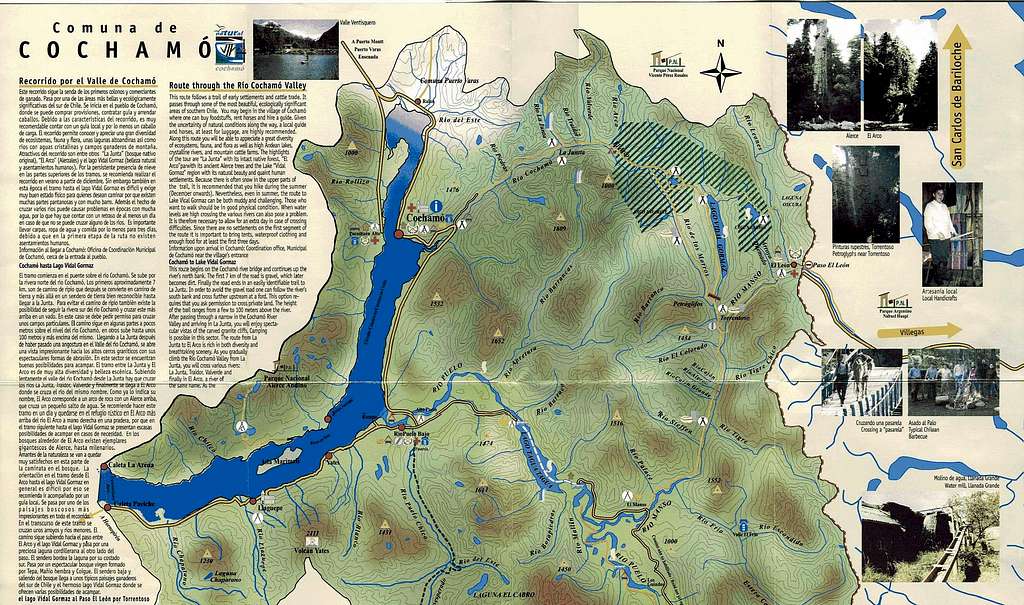 Area Map of Cochamo and the area surrounding Estuario del Reloncavi (the large fjord extending NE from Golfo de Ancud)
Cochamo Valley Detail Maps
The interactive map below shows the valley and the surrounding granite domes. Many of these trails are approaches to the various walls. Click on the colored lines for information about each route. The photo below the map shows the detailed hand crafted wooded map of the meadow and the directions to various features surrounding the valley. The beginning of the routes to different granite walls, crags, scramble routes, and important structures (like the bathroom) are shown. When you first arrive at the meadow, this is an excellent thing to look at and study up on. It sits right in the middle of the meadow close to the small hut. North is up.
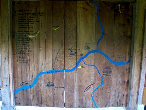 La Junta Detail Map (Click to Enlarge)
Gear Recommendations

- Bring at least two 60-meter ropes. Having more for fixed lines is helpful. The refugio has some ropes for fixing lines.
- At least one, maybe two sets of nuts with a large assortment of micros. Two sets of cams to 3 inches and at least one number 4 and 5, however the large cams can be rented at the refugio. One set of offset nuts are especially helpful.
- To get to some walls, pulleys can be essential. Some trails access walls by crossing fixed lines and cables that span rivers sometimes too difficult to cross by foot.
- Many first ascents require pins, pitons and other aid gear. Beaks are some of the most commonly used pieces.
- Many routes have not been properly equipped for raps, webbing has worn or weathered to a dangerous state. Bring extra cord (seems to last longer) and many quicklinks, especially stainless steel if you can get them and of course a rappel device, perhaps two in case you lose one.
- Many first ascensions require bolts. Please use only stainless steal hardware and bolts at least 10mm or 3/8" in diameter. You can buy stainless steel bolts and hangers (US$2.50 the set), and rent hand drills, hammer and power drill at the Refugio Cochamó. A US$500 deposit is required for the power drill. Please do not place bolts where traditional protection can be used!
- Having a port-a-ledge can be convenient on the rock especially if you get stuck in bad weather. Many climbers, however, leave the extra weight to lug around at home and decide to sleep on ledges, hang from hammocks or fix lines.
Other Gear
- Plan on staying at least a few weeks or month. The weather could leave you waiting for awhile, it takes time to get used to Cochamo climbing, approaches are long, and you will get sucked in longer than planned.
- Rain tarps can be much more comfortable to sleep and hang out under than tents in long periods of rain. They are also convenient for high camps.
- Rubber boots can be useful for crossing streams and mucking around on trails....which are always muddy
- Bring lots of food so that you do not have to make the journey back to Puerto Montt and minimize the trash you will have to carry out.
- Books, playing cards, slacklines, and other things to keep entertained on rainy days.
External Links
The Cochamo Valley Website has all you need to know about the place, and how to get to it.