
|
|
Route |
|---|---|
|
|
39.01220°N / 106.63015°W |
|
|
Mountaineering |
|
|
Summer |
|
|
Most of a day |
|
|
scramble |
|
|
Getting There
From the town of Aspen, drive roughly 10 miles east on Route 82 until you see the sign for the Lincoln Gulch Road (Forest Road 106) on the right (south) side of the road.Guidebooks might say that most cars can drive up Lincoln Gulch Road but I found it to be pretty rough and will not drive it in anything less than an SUV.
Drive the pot hole ridden Lincoln Gulch Road east. After 3.3 miles, you will reach the junction of New York Creek Road. Continue straight (left). 0.75 miles later you will reach the Tabor Creek Trailhead.
After the Tabor Creek Trailhead, the road seems to become much smoother. It continues east for another 2.5 miles to reach the Grizzly Reservoir. Here the road turns south and becomes rough again. 4WD is recommended. Drive the road another 3.5 miles to reach the signed junction of the trail to Anderson & Petroleum Lakes (11200 ft)
Route Description
All distances are per my GPS.At the trailhead cross to the west side of Lincoln Creek (You may want to do this with your vehicle. In late August of 2009, water level was low and I could easily cross the stream. In early July of 2010, water level was much higher but we could find a spot that allowed us to cross without getting wet).
Follow an abandoned Jeep Road 1.1 mile to reach Anderson Lake.

Trail to Anderson Lake
Identify Point 13105 ft to the west and go up the steep grassy slopes to the top of Point 13105 ft.

Point 13105 ft
(Just below Point 13105 ft, I decided to steer south and traversed a scree slope to reach the saddle between Point 13105 ft and a bump to the south of it. This slope turned out to be quite tedious. It is probably better to hike all the way up to the top of Point 13105 ft)

Traverse
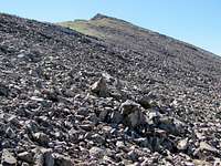
Once you reach the top of Point 13105 ft, turn south and descend the ridgetop 100 ft to reach a saddle between Point 13105 ft and a bump to the south of it. Follow the rocky ridgetop south up to the top of the bump.

Anderson, 13503 & bump
You will then see Point 13503 ft to your southeast. The slopes to the west and south side of Point 13503 ft are quite mild and will allow you to bypass the point to reach the base of the summit of Anderson.
SW slopes of 13503