
-
 9188 Hits
-
 76.66% Score
-
 7 Votes
|
|
Route |
|---|---|
|
|
38.85740°N / 104.9988°W |
|
|
Hiking |
|
|
Spring, Summer, Fall, Winter |
|
|
A long day |
|
|
Class 1 trail to Class 2+ scrambling |
|
|
Overview
Roundtrip mileage: 14.5 milesCumulative elevation gain: 3,800 feet
This is a relatively long route with a respectfully beefy elevation gain. The majority of the route is on-trail, topped by a brief off-trail hike and scramble to the summit. After rising above the crowded Barr Trail switchbacks, the solitude increases step-by-step and the scenery gets better and better. If the mileage and gain seem daunting, make a weekend of it by spending an evening at Barr Camp.
 Windy Day, Eastern Ridge of Pikes Peak
29 Mar 2009
The irony of this route is that, after sharing the lower reaches of the incredibly popular Barr Trail with hoards of other users, upon turning off the Barr Trail toward UN 10,245 B, the solitude becomes almost startling. According to the summit register placed by Mike Garrett, only a few intrepid summit seekers have enjoyed this highpoint over the past several years. Most of these names could be said to be among the “usual cast of characters” signing in on obscure summits across the Pikes Peak region.
Getting There
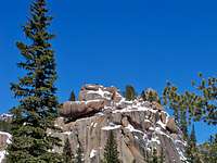 Closeup of a frosted rock outcrop Closeup of a frosted rock outcrop29 Mar 2009 | From Colorado Avenue in Manitou Springs
|  Rock Outcrop en Route Rock Outcrop en Route29 Mar 2009 |
 Click map image to enlarge
Route Description
- Leave the parking lot and head west up the Barr Trail switchbacks. These switchbacks seem interminable. Be alert for die-hard runners sharing the trail in all seasons.
- Do not be tempted by the numerous trails (official, social, game, and otherwise) ; stay on the main Barr Trail.
- After roughly two miles the climbing eases somewhat while traversing along the southeast slopes of Rocky Mountain.
- The trail then dips into a valley which serves as somewhat of a meeting space / snack spot / turnaround for many parties. There is a trail junction here. Stay to the left toward Barr Trail.
- After another steep climb up a wooded slope, the grade levels out somewhat as the Barr Trail follows a gentle ridgeline for about two miles.
- The trail then begins a gentle descent toward Barr Camp. At this point, your hiking party groans about the elevation loss.
- At mile 6.5 You will reach a bit of an opening. The unranked but visually prominent outcrop "Montes View Rockpile" will become visible on your left. A sign will appear informing the hiker Barr Camp is only ½ mile up the trail.
- Follow a use trail (identified on the Pikes Peak Atlas as #620) due-north from this point. You’ve only got about another mile to go!
- The use trail will bring you to a wet meadow. From here your objective is visible.
- Continue on the trail a way to avoid the “dreaded willows”, then begin charting your course, via the path of least resistance, toward the summit. The scrambling can range from Class 2 to Class 3 depending on route finding.
- The summit of UN 10,245 is the northern-most point of the mountain. It is a large granite slab, perfect for enjoying lunch, with a front-row view of Pikes Peak that will knock your shorts off!
 Click map image to enlarge
 Approaching UN 10,245B from the south
29 Mar 2009
 Sub-Alpine meadow on the approach to UN 10,245B
 29 Mar 2009
Essential Gear
- Trail map (Trails Illustrated #137 (Pikes Peak, Cañon City) would meet most needs)
- Compass
- Trekking pole(s)
- Sturdy hiking boots with grippy soles and stiff ankle support
- Snowshoes or skis might be needed in the winter after a heavy snowfall along Barr Trail; the need for floatation after leaving Barr Trail would depend on seasonal snow-depth
- YakTrax, Stabilicers, instep crampons or similar traction devices will be very useful on the packed, icy lower reaches of this route
- Water and snacks
- A camera to save memories of the high country views
- First aid kit
- Other standard backcountry essentials
External Links
Barr TrailBarr Camp
The Incline
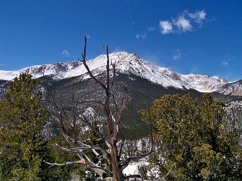 Pikes Peak from the summit of UN 10,245B
29 Mar 2009