
|
|
Route |
|---|---|
|
|
42.44190°N / 13.68320°E |
|
|
Hiking, Mountaineering, Scrambling |
|
|
Spring, Summer, Fall |
|
|
Most of a day |
|
|
II |
|
|
Overview
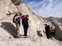
The S-side approach to Monte Prena is easily recognizible from the road running on the Campo Imperatore plateau. It an interesting ascent in a lonely environment characterized by gravelly valley and slopes, a rocky ridge, little towers and pinnacles, amusing climbing passages on little rocky wall and chimney (sometime friable, sometimes better). As well as the quite parallel route “Via dei Laghetti”, this route presents some alpinistic difficulties. It is classified by the guides at most UIAA II grade, but some exposed passages, even if short, are requiring caution and suitable equipment for belaying. ![Via Brancadoro]() The route attackThe route described is a combination of the ascent route named “Adelelmo Brancadoro” with the Normal route, choosen for coming back. Considering the difference in altitutde, about 1000 meters, and the tiring approach to the mountain, good health and suitable weather conditions are requested. Fog and clouds could make difficult the orientering. The yellow-red indications are now faded and the trail, in some part only traces, from this point of view does not help very much. Take with you enough water; no wells or streams are available.
The route attackThe route described is a combination of the ascent route named “Adelelmo Brancadoro” with the Normal route, choosen for coming back. Considering the difference in altitutde, about 1000 meters, and the tiring approach to the mountain, good health and suitable weather conditions are requested. Fog and clouds could make difficult the orientering. The yellow-red indications are now faded and the trail, in some part only traces, from this point of view does not help very much. Take with you enough water; no wells or streams are available.
 The route attack
Getting There
Leave your car on the road (S.S. 17 bis) running along Campo Imperatore where it cross the gravelly bed of the Fornaca, few kilometers before the junction with the road to Fonte Vetica. As alternative, someone suggests to take a not-asphalted road, departing from S.S. 17 bis, 2 km before the deviation to Fonte Vetica, and to follow it till the first cross; however it is not clear if it is forbidden or not.
For a detailed description see "Getting there" section of the main page of Monte Prena
- 420m up to the saddle among Veticole and Monte Prena (1970m);
- 580m from the saddle up to the summit (2561m)
Descent: about 1000m from the summit to Campo Imperatore - Time: 2:00-2:30
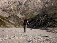
![Towards the canyon]() Walking along the Fornaca valley
Walking along the Fornaca valley
The ascent
For a detailed description see "Getting there" section of the main page of Monte Prena
Route Description
Ascent: about 1000m from Campo Imperatore to the summit - Time: 4:30-5:00- 420m up to the saddle among Veticole and Monte Prena (1970m);
- 580m from the saddle up to the summit (2561m)
Descent: about 1000m from the summit to Campo Imperatore - Time: 2:00-2:30
 Walking along the Fornaca valley
The ascent
Walking within the bed of the Fornaca valley reach by about 4 kilometers the base of a spur, 100 meters before an hydraulic barrier, turn left and ascend it following some traces.
Continue hiking on the slope up to a saddle at 1970m separating a little elevation (Veticole) and the Monte Prena. Take a rest before starting the harder part of the route.![The saddle]() The saddle
The saddle
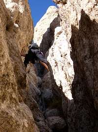
Ascend towards N till a plate indentifying the start of the “Via Brancadoro”. The climbing section is characterised by a chimey of about 90m with pasasages at most UIAA II grade (according to TCI-CAI guide), followed by two little walls of about 10m each, rated UIAA II. Some guides report the passages with higher rating (III grade).
![Via Brancadoro - the chimney]() The chimney
The chimney
![Via Brancadoro - the chimney]() The chimney
The chimney
In my opinion, the passages are quite exposed, excepted the chimney, and considering the not good rock quality, caution is absolutely required (possible places for belaying). These passages are connected by little gravelly and rocky channels, interrupted by saddles. Reached the last saddle at 2330m, continue following the “Via dei Laghetti”, along an evident and not difficult ridge, up to the the main ridge connecting Monte Prena with Monte Camicia. Turn left up to the summit [2561m].
![Climbing Via Brancadoro]() Getting-out
Getting-out
The descent
After few meters on the E-ridge, the descent starts along a channel on the N-side of the Monte Prena, having in front of you the rocks of Cimetta and the route coming up from Pagliara.
Take care to the traces and to the slippery rocks. Going-back fastly, arrive at a saddle on the E-ridge towards the Monte Camicia, ascent a little elevation, arriving again at the saddle called Vado Ferruccio at 2245m. Here clear indication show you the route for the descent on the S-side. By a more evident trail descend the valley on the SW side of Monte Camicia. On your right is visible the ridge where in the past a bivouac was placed (Bivacco Lubrano). The bivouac was destroyed cause of an avalanche. The deascent continue on the same side till you arrive at a road coming from an old mine of lignite, now closed. By the flat road or again through the Fornaca arrive at your car.
Continue hiking on the slope up to a saddle at 1970m separating a little elevation (Veticole) and the Monte Prena. Take a rest before starting the harder part of the route.
 The saddle
Ascend towards N till a plate indentifying the start of the “Via Brancadoro”. The climbing section is characterised by a chimey of about 90m with pasasages at most UIAA II grade (according to TCI-CAI guide), followed by two little walls of about 10m each, rated UIAA II. Some guides report the passages with higher rating (III grade).
 The chimney
 The chimney
In my opinion, the passages are quite exposed, excepted the chimney, and considering the not good rock quality, caution is absolutely required (possible places for belaying). These passages are connected by little gravelly and rocky channels, interrupted by saddles. Reached the last saddle at 2330m, continue following the “Via dei Laghetti”, along an evident and not difficult ridge, up to the the main ridge connecting Monte Prena with Monte Camicia. Turn left up to the summit [2561m].
 Getting-out
The descent

After few meters on the E-ridge, the descent starts along a channel on the N-side of the Monte Prena, having in front of you the rocks of Cimetta and the route coming up from Pagliara.
Take care to the traces and to the slippery rocks. Going-back fastly, arrive at a saddle on the E-ridge towards the Monte Camicia, ascent a little elevation, arriving again at the saddle called Vado Ferruccio at 2245m. Here clear indication show you the route for the descent on the S-side. By a more evident trail descend the valley on the SW side of Monte Camicia. On your right is visible the ridge where in the past a bivouac was placed (Bivacco Lubrano). The bivouac was destroyed cause of an avalanche. The deascent continue on the same side till you arrive at a road coming from an old mine of lignite, now closed. By the flat road or again through the Fornaca arrive at your car.