
-
 17416 Hits
-
 92.04% Score
-
 37 Votes
|
|
Route |
|---|---|
|
|
45.85231°N / 6.89860°E |
|
|
Mountaineering, Trad Climbing |
|
|
Summer |
|
|
Most of a day |
|
|
Alpine ED - |
|
|
5.11b (YDS) |
|
|
11 |
|
|
Overview
In honor of Rahel Maria Liu, fallen during the ascent of the Innominata Spur on the southern face of Monte Bianco, who climbed the Swiss Route on 2004, August 2nd
Swiss Route on Grand Capucin SE face
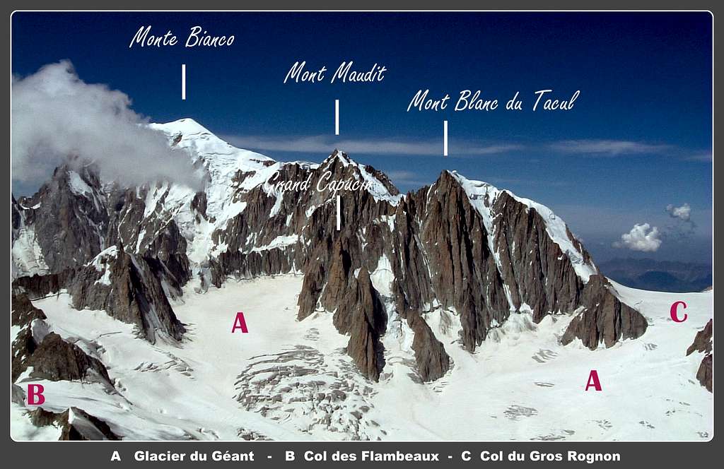
This classic route dating 1956 runs on the sublime obelisk of Grand Capucin, a huge arrow of exceptional red protogyn granite thrown towards the sky, rising steeply out of the Glacier du Géant on the left-hand side of Mont Blanc du Tacul. A historical route, the easiest one to get the summit of Grand Capucin, but anyhow challenging, involving both high level free climb and aid climb. Also surrounded by numberless outstanding modern routes, perfectly equipped, nowadays Swiss route hasn’t lost its value.

It deserves to both “old school” climbers and free-climbers a charming adventure in a superb milieu: to the first ones the possibility to climb it by the old style, to the second a challenging free-climb reaching the 6b grade (5.11) with some aid points or, totally free-climbing, the 7b (5.12b). Quick parties can climb the route in 1 day, both from Courmayeur and Chamonix, but the best solution is largely to overnight at Rifugio Torino or at Refuge des Cosmiques, both for a more relaxed climb and a good acclimatization.
Getting There

Approach from Courmayeur
The best starting point is Courmayeur, lying in the Italian side of Monte Bianco, close to the entrance of Tunnel of Monte Bianco; the peak can be reached also from Chamonix, in the French side of Monte Bianco, but the approach walk to the peak on the glacier is quite longer.
- From Turin and Milan: follow the A5-E25 Motorway and exit Courmayeur, reaching the hamlet of La Palud m. 1370.
- From France: through the Tunnel of Monte Bianco
- From Switzerland: through the Great St.Bernard Tunnel or the Great St.Bernard Col or via Chamonix and Tunnel of Monte Bianco.
Getting to Rifugio Torino
From Entrèves - La Palud take the cable-car leading directly to Rifugio Torino (exit second station, the first one is the middle Pavillion station, the third one is Punta Helbronner). FUNIVIE DEL MONTE BIANCO
Approach from Chamonix
Getting to Chamonix from Switzerland:
- From Martigny follow the road leading to the Switzerland – France border, then to the village of Argentiere and to Chamonix (44 km. from Martigny, 12 km. from the border). - From Geneva follow the E25 Motorway to St. Gervais les Bains, then the RN 205 to Chamonix
Getting to Chamonix from Italy
- Through the Mont Blanc tunnel from Courmayeur Once getting to Chamonix take the Téléphérique de l’Aiguille du Midi. Info on COMPAGNIE DU MONT BLANC
From the upper cable-car station descent the snow-slopes of Aiguille du Midi, gaining the glacier; skirt the Aiguille du Midi South face heading to the Refuge des Cosmiques.
Approach to the route
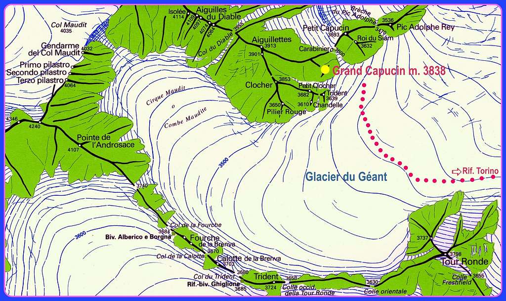
- From Rifugio Torino m. 3375, or from the upper station of Punta Helbronner m. 3470, cross the Col des Flambeaux m. 3407 and go down on the left along the glacier heading towards the North side of Aiguille di Toula, then rising towards West to skirt the North face of Tour Ronde; cross the Glacier du Géant towards right, heading to the magnificent red towers of Capucins (a few crevasses) and getting to the glacial basin lying below Grand Capucin (on the left) and Petit Capucin (on the right). Cross the bergschrund, sometimes high and difficult and needing good conditions, on the right and enter the Couloir des Aiguillettes, separating Grand Capucin on the right from Trident du Tacul on the left. Climb the snow-gully at 45°-50° for about 120 meters, then go slant to right climbing some broken rocks to gain the bottom of the great slanting corner, overhung by a terrace, giving the line of the first section of the route. (3 hours from Rifugio Torino). The starting point is situated at about the half of the gully.
")
- From the Aiguille du Midi, cross the Valleé Blanche towards the Col du Gros Rognon, enter the Géant Glacier, skirting on the right Pointe Lachenal and the huge East face of Mont Blanc du Tacul, then Pyramide du Tacul and Pic Adolphe Rey and getting to the glacial basin below Grand Capucin and Petit Capucin. From here same approach as from Rifugio Torino.
Route Description

Swiss Route report - French Scale Summit altitude: m. 3838
Difficulty: Alpine ED-, 6b max, 6a obbl. and A1, 7b all free-climbing
Climbing length: 300 m
Equipment: partially equipped (some pegs along the pitches, equipped belays); nuts and friends needed
Time required: from 5 to 7 hours
Exposure: SE
First ascent: Claude Asper, Marcel Bron, Mario Grossi, Marcel Morel 1956, july from 24th to 26th
Huts: Rifugio Torino m. 3375, Refuge des Cosmiques m. 3613
Starting points: Courmayeur m. 1224 or Chamonix m. 1030
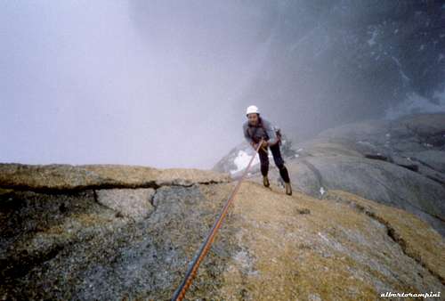
A magnificent classic climb on the typical high class red protogyn granite of Monte Bianco, running at first on a great slanting corner, then following a challenging line amongst roofs, involving some aid climbing or very strenuous free-climbing.
Route report
L1 - L2 The first two pitches climb a grey slab, a reddish step and another more difficult slab leading to the base of the slanting corner. 4b, 5b
L3 – L4 – L5 - Climb all the corner up a crack on the left of the corner, getting to a good stance on a shoulder (sometimes covered by snow). 6a
L6 – You must follow the line of the pillar; on the right of the stance climb another corner, overhung by a reddish wall. 5c, 6a
L7 – L8 – Climb it towards a black roof. V+, A1
L9 - Traverse right below the roof (A2), then climb a crack to another roof. Up the roof. A2
L10 – Climb some slabs and cracks to a terrace. V, IV
L11 – Climb a corner, then easier slabs and an ending corner to the beautiful summit. V, IV.

|

|
Starting the rappels
Descent
The best descents are:
- rappelling on the route “O sole mio” (less direct, but new equipment) to the terrace at the top of Swiss Route fifth pitch, then on the same Swiss route down to the foot (6 abseils with a 60m rope)
- rappelling on the route “L’echo des alpages” on the same SE face along a direct line. The first anchor is lying 1 meter below the summit, on the right facing to Mont Blanc du Tacul. Eight abseils to reach the basal bergschrund.
- rappelling on the route "Voyage selon Gulliver" which follows the SE spur (new equipment), if nobody is climbing up the route.
Essential Gear
Rope 2x60 m, helmet, quickdraws, a full set of friends and nuts; ice-axe, crampons and gear for the approach on the glacier are needed
Red Tape
No particulary restrictions in climbing and hiking.
Huts
- Rifugio Torino m. 3375 – C.A.I. Sez. di Torino
- Refuge des Cosmiques m. 3613 – C.A.F.
When to climb
Best season goes from July to September
Meteo
Meteo Regione Valle d'Aosta
Meteo Chamonix
Meteo Chamonix
Guidebooks and maps
- Guidebooks “Le topo du Massif du Mont Blanc” Tome 2 by Michel Piola – Editions Equinoxe
“Monte Bianco” Vol. I by Gino Buscaini – Collana Guide dei Monti d’Italia CAI-TCI
“Mont Blanc Supercrack” by Lamberto Camurri and Giovanni Bassanini, 2012

- Maps
- Meridiani Montagne “ Monte Bianco” map 1:30.000
- Swiss Topo 292 Courmayeur
- IGN 3531ET St.Gervais Les Bains – Massif du Mont Blanc